You are using an outdated browser. Please upgrade your browser to improve your experience.
Camping Tent

Grab Your Gear and Pop a Tent with These Camping Apps

If you are ready to head out with your tent or RV, make sure you have the tools you need. These awesome iOS apps will help you locate a campground, find hiking trails, give you grilling ideas, and more.

Find the Perfect Spot

When you are ready to start planning your next camping trip, these campground finders can help you find the ideal site.

Allstays Camp & RV - Road Maps

Allstays Camp & RV - Road Maps

Allstays LLC

Allstays Camp & RV - Road Maps

For those interested in a campground locator that provides rest area, fuel, and repair spots.

Camp & RV from Allstays LLC provides a simple way to find the campground that’s right for your next outdoor adventure. The app includes filters for finding the perfect spot, whether it be for tent or RV camping. You can also check out rest area locations, parking lots, and repair centers.

Why we love it

For finding your ultimate campground, Camp & RV is the way to go.

KOA | RV, Cabin & Tent Camping

Find official KOA campgrounds for tents, RVs, and cabins in the U.S. and Canada.

KOA | RV, Cabin & Tent Camping

Get full details and book

For those who like KOA campgrounds and want to reserve sites directly from the app.

KOA Campgrounds is a terrific app for locating KOA sites. The app not only provides campground and site details, but also includes hot deals, campground maps, filtering options, notifications, and more. Whether you have a tent or RV or would rather stay in a cabin, this app makes it easy to find the perfect spot.

Why we love it

KOA Campgrounds is the best way to find KOA locations across the U.S. and Canada. Once you find the spot you want, you can book your site from the app with a tap.

USFS & BLM Campgrounds

USFS & BLM Campgrounds

William Modesitt

USFS & BLM Campgrounds

For those interested in a campground locator that provides offline maps.

USFS and BLM Campgrounds offers 5,800 campgrounds provided by the United States Forest Service (USFS) and Bureau of Land Management (BLM). You will also find photos, local weather, and offline maps. Search, explore, and save your favorites with this handy campground locator.

Why we love it

USFS and BLM Campgrounds helps you find just the right campground.

Trek the Trails

If you and your family enjoy brisk hiking journeys on your camping trips, then apps that shows you the details before you go are handy and helpful.

Gaia GPS: Mobile Trail Maps

Gaia GPS: Mobile Trail Maps

TrailBehind

Gaia GPS has been wholly reinvented in this latest version, bringing all of the features that have made the app so successful in the past few years. It offers downloadable topographic, satellite, and road maps, perfect for those trips off the beaten path. The interface has been carefully thought out to make navigating the back country easier than ever. You can even record tracks, way points, and other crucial data for finding your way through the woods.

more info
ADK 46er Now
ADK 46er Now

ADK 46er Now

One Bad Ant

One Bad Ant's Apex App
(but hopefully not One Bad Ant's App apex!)

If you like hiking the Adirondack High Peaks, the smell of pine, the views from the High Peak summits, and like gear and technology that doesn’t come between you and your hike then the ADK46erNow app is the app for you!

Whether you’re a multiple 46er, or you’re tackling your first attempt to climb the 46 High Peaks then this app is for you. It is designed to be easy to use, to compliment your summit efforts, and not distract from your hike.

You can plan your hikes and summit attempts in advance, or, if you prefer to be spontaneous, then simply select the peak to hike and press the start button.

Once you are on the trail the ADK46erNow app provides you with a variety of tools to use - compass, GPS location, surrounding peak identifications, weather forecast, maps, and the ability to add trip notes and attach photos to your hike.

Stamp your summits by manually recording them or press a button when you reach a peak and automatically record the current time and weather forecast.

And finally share your summit plans and accomplishments including trip notes and photos with friends, family and fellow hikers via email or Facebook!

Enjoy and hike responsibly!

Features:

• Compass: Tap the app logo on the home screen to reveal the compass. Tap it again to dismiss it.
• The Progress Bar: Your summit progress bar appears at the bottom of the app’s home screen along with a count of the summits you’ve reached for your current itinerary.
• Your Log Book: Plan an itinerary (or multiple itineraries) for summiting the 46 Adirondack High Peaks. Assign planned summit dates, and automatically stamp your summits with time, date, GPS location, and current weather forecast.
• Record your hike notes and assign photos to your summits.
• As you hike, use the three “Journal” and “Info” features to locate your current position on a map and by GPS. The “360 Degree View” will identify the surrounding peaks within a five or ten mile radius.
• The Summit Stamp gives you a one-click stamp your summit achievements recording the summit date and time and weather.
• The Peaks: Find the shortest round trip or the longest? Discover which peaks are trailed or not? Access a variety of map options including topo maps.
• And much more!

more info
Natural Lands
Natural Lands

Natural Lands

Weblications

Ditch those paper trail maps! With ExploreNLT, find places to hike, trail run, bird watch, and get back to nature at more than a dozen Natural Lands Trust nature preserves in eastern PA and southern NJ.

Find a Natural Lands Trust preserve near you with the GPS-powered map or search by zip. Then use integrated driving directions to get there.

Learn about the not-to-be-missed features, special plants, native wildlife, and cool activities you’ll find at each preserve.

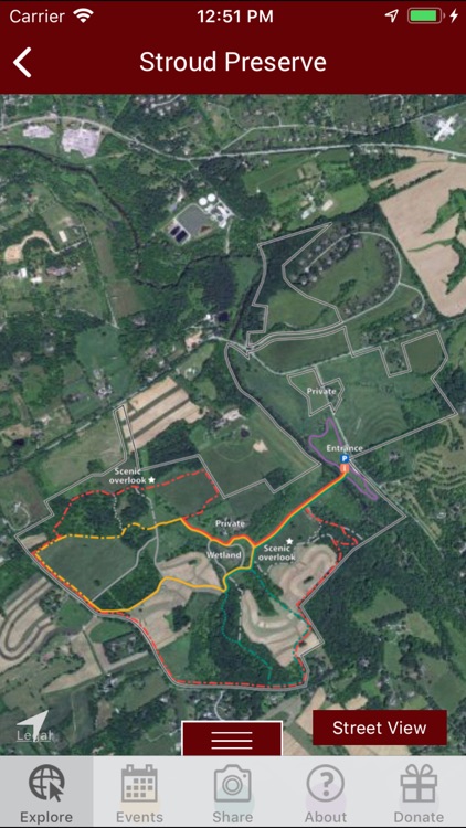
Explore trails with confidence using interactive trail maps.
Share your outdoor experience with friends by easily uploading photos to Facebook, Instagram, and Twitter.
Sign up for cool events like butterfly rambles, bird walks, star-gazing gatherings, tree-planting parties, and more.

Key Features:

- You can’t explore if you can’t get there. Integrated driving directions—and a direct connection to Apple Maps—will get you on the right track.
- Don’t get lost… unless you want to. GPS-powered, color-coded trail maps mean you’ll always know where you are and where you’re going.
- Works in offline mode! Most features—including trail maps—will work even when you don’t have cell reception or wi-fi.
- Poncho, sunscreen, or snowshoes? Live, local weather will help you plan accordingly.

About NLT

Natural Lands Trust is dedicated to saving land, stewarding natural resources, and connecting people to nature in eastern Pennsylvania and southern New Jersey. Since 1953, Natural Lands Trust has preserved more than 100,000 acres. Today, millions of visitors enjoy the healthy habitats, clean air and water, bountiful recreational opportunities, and scenic beauty provided by the lands the organization has preserved. For more information, visit www.natlands.org.

Thanks

Thank you to the Claneil Foundation and Dolfinger-McMahon Foundation for funding ExploreNLT, and to The Trustees of Reservations, a like-minded organization based in Massachusetts with which we partnered on this project.

more info

Cook Up a Camping Special

Cookbooks designed specifically for campers give you simple yet tasty options for your adventure in the great outdoors.

Be Prepared for Emergencies

There are plenty of dangers to stay aware of when you are camping in the wilderness. Be prepared before you go with first aid apps that can be real life-savers.

Easy app navigation
First Aid: American Red Cross

First Aid

American Red Cross

Who better to assist you in a medical emergency than the American Red Cross?

First Aid by American Red Cross provides emergency preparedness, first aid, information to learn more, and a hospital finder for your location.

Grill a Great Meal

There is no better meal when you are camping outdoors then a tasty dish cooked on the grill. These apps will give you delicious BBQ and grilling ideas.

Omaha Steaks
Omaha Steaks

Omaha Steaks

Omaha Steaks International, Inc.

The first time you sign into the app you’ll receive 100 reward points to redeem towards premium Omaha Steaks products with your next purchase!

The Omaha Steaks app is loaded with gourmet-focused features from easy shopping and gifts to Steaklover Rewards to a one-of-a-kind interactive steak cooking timer. It’s the complete experience for anyone who loves to make, eat, and share great food.

SCAN TO BUY
Use your smartphone’s camera with your Omaha Steaks catalogs and experience the newest, most convenient way to shop. Just point your camera at any page of the catalog and you’re shopping our deals in the app.

STEAK & COOKING TIMER
Don’t guess at the grill! Your Omaha Steaks app includes a helpful interactive timer that’s at your side the whole time you’re cooking. Expert-chef presets for steaks, roasts, seafood, and smoking/barbeque are built in.
• Custom directions for what you’re cooking
• Add as many different items as you want to your timer
• Complete step-by-step directions before you start
• Countdowns and heads-up for the next step
• Notifications and audio alerts as you cook
• When to flip; When to turn; When to remove; Resting time
• Cook anything from a small grilled filet mignon to a full smoked brisket

RECIPES
The complete library of Omaha Steaks-approved recipes is here. Find your new favorite by steak, by meal, by ingredients, or by occasion… the app will teach you how to create something amazing for your table.

STEAKLOVER REWARDS
Members of our rewards program get free Omaha Steaks food items, discounts when they shop, and exclusive deals. Use the app to easily track your points, shop for the latest, and redeem when you’re ready. Not a member yet? Join Steaklover Rewards with just a few taps.

GIFTS
Omaha Steaks huge selection of can’t-go-wrong gourmet gifts is here, easy to find and send within the app. It takes just a few minutes to shop by recipient, occasion, budget, or send a gift card.

STORE LOCATOR
Improved map functionality makes it easy to find the nearest Omaha Steaks store.

NOTIFICATIONS
Your Omaha Steaks in-box where you will get personalized deals and the inside scoop on what’s going on at Omaha Steaks.

more info
Tappecue
Tappecue

Tappecue

Innovating Solutions LLC

The Tappecue App has revolutionized the cooking experience through real-time online social cooking. Monitor yours, your friend’s and/or family’s smoking session and show up when the meat is done or give them a call or run back home when a temperature has gone astray. Never under/overcook your food again because the Tappecue App will alert you when your meat is done and when your chamber temperature has gone out of its range. Be an expert chef and impress all your friends because with Tappecue – you’ll always be one tap away from your barbecue. The Tappecue System comes with many features:

—Now introducing Tappecue SessionBook; your customer exclusive Cloud Diary for your smoking sessions. Record, improve, and become an expert BBQ chef with the help of Tappecue SessionBook.
—Monitor multiple Tappecues from anywhere on as many devices as desired on (iPhone/iPod Touch/iPad with software iOS 10.x) or any browser for monitoring from any computer/tablet/WiFi TV, etc at www.tappecue.net
—Alerting Functionality for user(s).
—Unlimited Power for those long eight hour smokes.
—Four Meat/Chamber Probes.
—Guest Mode Functionality allows multiple users to view your temperatures and receive alerts.
—Gather Analytical Data (you can graph temperatures in excel).
—Expert in a Box
—Preset temperatures for different meats
—Add different meat types
—Coming soon – recipes and cooking tutorials from professional BBQ chefs.
Preset temperatures for different meats
Add different meat types
Be a part of the social cooking revolution by purchasing your own Tappecue at www.tappecue.com


System Requirements
You are required to have the following to use the Tappecue Temperature Monitoring System:
• An Internet enabled smart device – iPhone/iPod Touch with software iOS 10.x or above.
(although you may still look at the temperatures on the actual device LCD Panel),
• Wi-Fi Router or Mobile Hotspot,
• Grill/Smoker/Oven/stovetop/any source of heat

Contact info@innovating-solutions.com if you are unsure if Tappecue is the right solution for you.

more info

Tie up the Loose Ends

Whether you plan to tie down a structure or head out on a boat on your camping adventure, make sure you know which knots you need for land and water and also how to tie them.

Animated Knots by Grog

Animated Knots by Grog

Grog LLC

Animated Knots by Grog

For those who want to learn to tie knots with animated tutorials.

Animated Knots by Grog from Outside Magazine is a terrific source for your knot-tying needs. You can view step-by-step photo animations, making learning simple. The app includes an enormous variety of options from a barrel hitch to a sheepshank to a water knot. Whatever knot you want, you’ll get with Animated Knots by Grog.

Why we love it

For the easiest way to learn to tie knots, Animated Knots by Grog has easy instructions and detailed information.

What Knot To Do

For camping, fishing, or boating, know which knot you need and how to tie it.

What Knot To Do

Pick a category and choose your knot

For those who want instructions for tying knots correctly.

When you need to tie a knot, What Knot To Do shows you how. With simple navigation, you just select a category such as camping or boating and pick your knot. If you are not sure which one you need, check the glossary. And, when you are ready, you can easily follow the step-by-step instructions to tie that perfect knot.

Why we love it

Find the correct type of knot for your activity and learn how to tie it with What Knot To Do. Whatever your next great outdoor adventure; this app has the knot for you.