You are using an outdated browser. Please
upgrade your browser to improve your experience.

Pokéchez is an offline navigation service application packed with sightseeing information

PocketShelter Plus
by Pocketshelter Co.,Ltd.


What is it about?
Pokéchez is an offline navigation service application packed with sightseeing information. In the event of a disaster it will automatically switch to the disaster prevention mode in coordination with warning systems. It is a sightseeing and a disaster prevention application that will help in saving lives when it comes to emergencies.
App Screenshots
App Store Description
Pokéchez is an offline navigation service application packed with sightseeing information. In the event of a disaster it will automatically switch to the disaster prevention mode in coordination with warning systems. It is a sightseeing and a disaster prevention application that will help in saving lives when it comes to emergencies.
You can select the types of pins to be displayed on or hidden from the map by tapping the "Filter" button on the home screen.
(In case of a disaster warning, it will automatically display only the pins with information related to disasters.)
Disaster prevention functions fully include what can be used while offline in the event of a disaster while taking advantage of what had been learned from earthquake disasters of the past.
This is an application providing total support from disaster notifications to instructions on actions for evacuation and confirmation of safety.
▼ Tourism
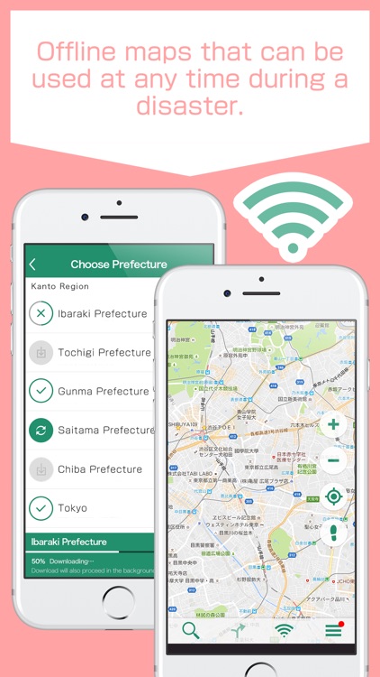
· You can search for addresses on maps while offline!
· Linkage with Twitter! You can check tweets about places.
· Category search / navigation can be carried out on offline maps!
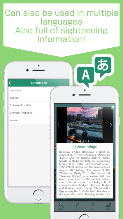
· Multilingual support (Japanese · Simplified Chinese · Traditional Chinese· Korean · English)
▼Disaster prevention
· Instant push notifications for earthquake emergency reports / tsunami reports / ballistic missile warnings
· Instant display of nearby evacuation related facilities when the disaster mode is activated
· Automatic sending of safety confirmation emails
While this is a usual tourist navigation tool, it is also a disaster prevention application to protect your life in case of disaster!!
◆◆◆◆◆◆◆◆◆◆Features available with Plus+◆◆◆◆◆◆◆◆
■■Tourism■■
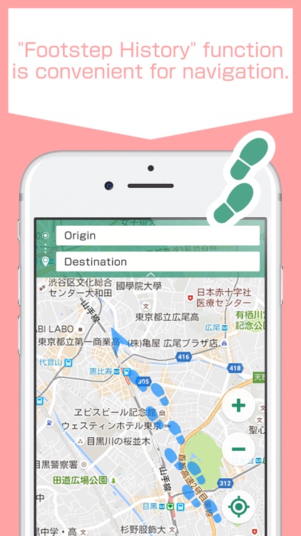
■ Offline Map Display / Navigation
■ Function available for the first time in the industry!! Address search on offline maps
■ All-Japan tourism information (multilingual support)
■ Check tweets related to the place you are planning to visit!
You may be able to be the first to get information on train service conditions and shop congestion situation!
■ Navigation, footprint marks while online
■■ Disaster prevention■■
Speedy delivery of push notifications of Earthquake Early Warnings, tsunami warnings and Ballistic missile warnings.
■Offline maps for when Wi-Fi is not available.
They are reassuring because they will navigate you to the evacuation facilities even when you are offline.
■Safety status confirmation in an earthquake
In case of an earthquake with an intensity of lower 5 or more, an automatic email to inform your safety status will be sent to the pre-registered addresses of your loved ones such as your family members, friends and significant others.
Since the mail will be sent to families in your home country, let's register contact information of important people in case of emergency.
■Notification Test enables you to conduct an emergency drill by yourself
Tap "Notification Test" and the Earthquake Early Warning test alarm will sound, audio navigation will play in several seconds, and a push notification will be delivered.
■Over 180,000 evacuation facilities, the largest number of entries ever among disaster protection Apps
■Search for nearby evacuation facilities
You can search for evacuation facilities by category and evacuate to a suitable place for the disaster.
The nearest facilities from the current location will appear first.
■Quickly check out necessary information: toilets, water stations, convenience stores and hospitals.
■Check out the past tsunami,earthquake history and ballistic missiles
■Automatically generated seismic intensity map
■Inform your acquaintances of where you are by sharing your location
You can share your current location via email, Twitter or Line etc.
■Personal Alarm: SOS
[Recommended Devices]
To use this App optimally, we recommend a device running iOS 8.0 or higher.
Please read through and agree to the Terms of Use / Disclaimer displayed during the initial launch before using the App.
Disclaimer:
AppAdvice does not own this application and only provides images and links contained in the iTunes Search API, to help our users find the best apps to download. If you are the developer of this app and would like your information removed, please send a request to takedown@appadvice.com and your information will be removed.
AppAdvice does not own this application and only provides images and links contained in the iTunes Search API, to help our users find the best apps to download. If you are the developer of this app and would like your information removed, please send a request to takedown@appadvice.com and your information will be removed.