You are using an outdated browser. Please
upgrade your browser to improve your experience.

in top
10
of its
category
10
of its
category


FREE in the App Store
Gaia GPS has been wholly reinvented in this latest version, bringing all of the features that have made the app so successful in the past few years. It offers downloadable topographic, satellite, and road maps, perfect for those trips off the beaten path. The interface has been carefully thought out to make navigating the back country easier than ever. You can even record tracks, way points, and other crucial data for finding your way through the woods.
Watch the trailer


Gaia GPS Offers Apple Watch App
Check the details on WatchAware
Check the details on WatchAware
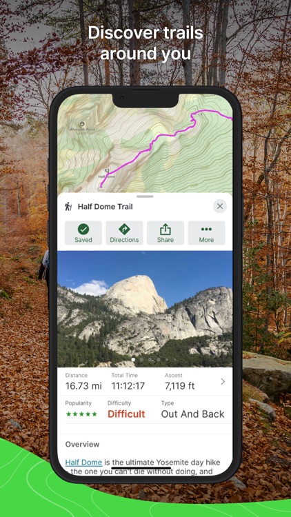
Plan a hike with Gaia: GPS. Gaia GPS provides you with topographic maps that you can use to plan your hike. You'll know right away where the elevation changes and other challenges might await you, and can plan your route accordingly. Using Gaia GPS, you can set waypoints to direct your route, and the app will automatically plan the best directions for you to take. It knows where streets and hiking trails are throughout most of the United States and Canada, and uses them to craft a route for you to take. Of course, you can always change that and redirect your path to take a more "as the crow flies" journey, if you choose.

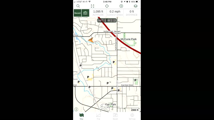
Choose your map source in Gaia: GPS. Within Gaia: GPS, you can choose your favorite map source. The app includes access to all of the USGS topographic maps, as well as terrific navigation images for Canada. You can also access Gaia's own map server, which covers the entire world. The maps will help you know where the elevation changes and other challenges might lie in wait, so you can traverse the trails in confidence. If you want a bird's eye view of the terrain, a satellite overlay is also available.
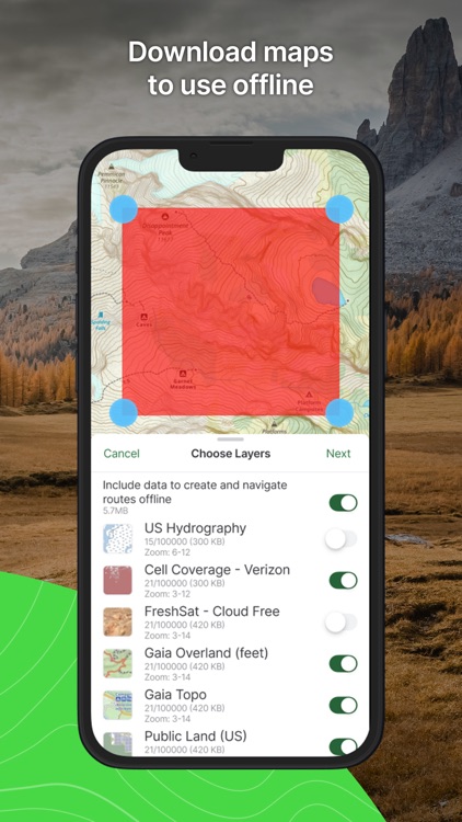
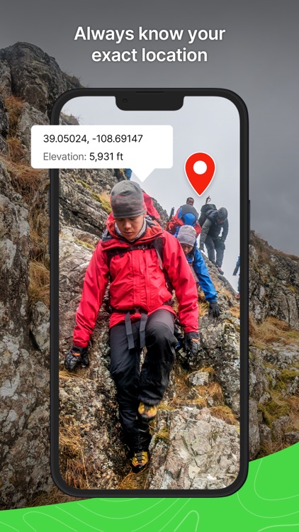
Save maps to your device for offline use. The internet isn't always available in the great outdoors, but your maps can be. With Gaia: GPS, you're able to download a map of the area you'll be hiking or exploring, so your navigation aid is available even when the internet isn't. Since Gaia uses your iPhone's built-in GPS, it keeps track of where you are as you traverse the trails.

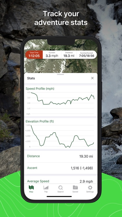
Record your hike with Gaia: GPS. Planning and viewing your hike isn't the end of what Gaia: GPS can do. Tap in the top left corner to record, and Gaia starts keeping track of your path. You can later view how well you "hiked the plan," and get ideas for new places to explore later. You can also use the recorded tracks to retrace your steps, if you want to find something you missed or just want to do more sight-seeing.
Access your camera right from within Gaia: GPS. No hike would be complete without photographs. After all, "pictures or it never happened." You don't even have to leave the app to snap a picture, since Gaia: GPS has conveniently placed a shortcut to your iPhone's camera within the menus. Snap a picture, and then go back to planning your next steps. You can keep a photographic trail of your travels through the back country, so you'll be able to revisit and relive the memories later.

What is it about?
Gaia GPS has been around for years, making wilderness exploration easier and safer than ever before. In the latest version, it's been infused with the best topographical maps available in the United States, Canada and other countries. Gaia GPS supports downloading maps for offline use, and allows you to save your tracks, way points, and maps to the cloud so you can access them from any of your iOS devices or computer. Search for trails, parks, natural features, and more from within one app.
For those who...
- Love adventuring in the back country
- Want to be able to record their journeys, including paths and way points
Not for those who...
- Don't like insects or anything else related to the so-called "great" outdoors
- Prefer to use handheld GPS devices over their iPhone
Why we love it
Gaia GPS has, and continues to, set the standard that other outdoors GPS apps have to live up to. It includes topo maps from the United States Geological Service, United States Forestry Service, and more. It even has its own vector-based topographic map of the entire world, and all of the maps are easy to download for use even when you have no internet connection. Allowing you to record and save tracks and way points, it's like having a standalone GPS device right in your iPhone.
App Screenshots


Gaia GPS is FREE but there are more add-ons
-
$9.99
Gaia GPS Member
-
$29.99
Gaia GPS Premium
App Store Description
Whether you’re out in the snow or exploring scenic hiking trails and amazing offroad routes, Gaia GPS has you covered. Spend less time looking at your phone and more time taking in the snowy landscapes with the newly redesigned app. Backpack, overland, discover campgrounds and skiing routes, or explore breathtaking hike trails thanks to Gaia GPS.
Make the wilderness your backyard with Gaia GPS. Enjoy the best hiking app, road trip planner, and backcountry navigator – all in one. Reach your next summit out on the snow with offline maps, GPS coordinates, and distance tracker features to help you explore the world around you.
Cruise through popular ski tracks or hike trails confidently with GPS navigation tools to guide you through national parks and nature routes. Download the premier outdoor activity app featured in publications like the New York Times, Washington Post, and GearJunkie.
BACKPACK OR HIKE
• Hike trails and running routes are available on Gaia Topo, the ultimate backcountry navigator.
• National parks or backcountry trails – Pave your path out on the snow with nature routes waiting to be explored
• Access the full NatGeo map collection
• Backpack along offroad hiking trails & back to base camp with breadcrumbs
• Distance tracker with altitude and elevation monitoring for each activity
BE READY FOR SNOW SEASON
• The Gaia Winter base map is designed for winter activities and works well with other winter layers
• Know current conditions with ski resort information and Nordic trails from OnTheSnow
• Skiing, snowboarding, and more – chase the snow with curated snow mobile trails
• Find the perfect snow with Snow Station and Snow Forecast map layers
• Ski reports help tackle any adventure safely with Slope Angle and Avalanche Forecast layers
ROAD TRIP PLANNER MADE FOR YOU
• Offroad travel is easy with GPS coordinates
• Offline maps: RV travel is easy with offline maps that track your location, even when far from cell service
• Road trippers can prepare with available parks, route conditions, and activity tracker features
OFFROAD ACTIVITY PLANNING
• 4x4 & overlanding adventures are easy to record on Gaia GPS
• Activity tracker and route planner make navigating trails offroad simple
• Follow ski tracks or create your own routes on the fly with snap-to-trail route building
• Maps, routes, and waypoints displayed directly on Apple CarPlay
EXPLORE THE WORLD LIKE A PROFESSIONAL
• GPS coordinates help explore the wilderness while creating routes and tracking progress
• Mark ski tracks, hike trails, routes, & campgrounds
• Share your data with clients & fellow guides to improve Gaia GPS
ELEVATE YOUR OUTDOOR ADVENTURES WITH GAIA GPS PREMIUM WITH OUTSIDE+
• Access 300+ maps including NatGeo Trails Illustrated, Private Lands, weather forecasts, and more
• Offline maps to download anytime.
• Weather, terrain, and safety features
• Access the Trailforks GPS biking app
• Expert-led online courses on Outside Learn
• Premium access to award-winning films, shows, and live TV on Outside Watch
• Unlimited digital access to Outside Network's 15 iconic brands including Outside, Backpacker and National Park Trips.
Explore the world with Gaia GPS to guide all of your wintry adventures. Enjoy GPS navigation, skiing features, and countless hike trails with Gaia GPS – your perfect outdoor companion.
SIGNUP
• Gaia GPS is part of the Outside Network. Create an Outside account to access the app.
TO MANAGE YOUR SUBSCRIPTION:
• TURN OFF auto-renewal: https://support.apple.com/kb/ht4098
• Subscriptions automatically renew unless auto-renew is turned off at least 24 hours before the end of the current period. You will be charged for renewal within 24 hours of the end of the current period.
• Your Apple App Store Account will be charged at confirmation of purchase.
• Privacy Policy: https://www.gaiagps.com/company/privacy
• Terms of use: https://www.gaiagps.com/company/terms_of_use
Disclaimer:
AppAdvice does not own this application and only provides images and links contained in the iTunes Search API, to help our users find the best apps to download. If you are the developer of this app and would like your information removed, please send a request to takedown@appadvice.com and your information will be removed.
AppAdvice does not own this application and only provides images and links contained in the iTunes Search API, to help our users find the best apps to download. If you are the developer of this app and would like your information removed, please send a request to takedown@appadvice.com and your information will be removed.