You are using an outdated browser. Please
upgrade your browser to improve your experience.
โปรแกรม GIS Guide เป็นลิขสิทธิ์ของบริษัท อีเอสอาร์ไอ (ประเทศไทย) จำกัด ซึ่งเป็นผู้ให้บริการระบบสารสนเทศภูมิศาสตร์และผลิตแผนที่ฐานที่มีความละเอียด ถูกต้องและคุณภาพสูงที่สุดในประเทศไทย โดยมีตำแหน่งสถานที่สำคัญมากกว่า 600,000 ตำแหน่งและระยะทางเส้นทางคมนาคมมากกว่า 700,000 กิโลเมตร

GIS Guide
by GIS Co., Ltd.


What is it about?
โปรแกรม GIS Guide เป็นลิขสิทธิ์ของบริษัท อีเอสอาร์ไอ (ประเทศไทย) จำกัด ซึ่งเป็นผู้ให้บริการระบบสารสนเทศภูมิศาสตร์และผลิตแผนที่ฐานที่มีความละเอียด ถูกต้องและคุณภาพสูงที่สุดในประเทศไทย โดยมีตำแหน่งสถานที่สำคัญมากกว่า 600,000 ตำแหน่งและระยะทางเส้นทางคมนาคมมากกว่า 700,000 กิโลเมตร
App Screenshots

App Store Description
โปรแกรม GIS Guide เป็นลิขสิทธิ์ของบริษัท อีเอสอาร์ไอ (ประเทศไทย) จำกัด ซึ่งเป็นผู้ให้บริการระบบสารสนเทศภูมิศาสตร์และผลิตแผนที่ฐานที่มีความละเอียด ถูกต้องและคุณภาพสูงที่สุดในประเทศไทย โดยมีตำแหน่งสถานที่สำคัญมากกว่า 600,000 ตำแหน่งและระยะทางเส้นทางคมนาคมมากกว่า 700,000 กิโลเมตร
GIS Guide จะทำให้คุณสนุกสนานไปกับการใช้งานแผนที่ประเทศไทยโดยไม่มีค่าใช้จ่าย ซึ่งพัฒนาให้ใช้เทคโนโลยี Augmented Reality (AR) ที่แสดงตำแหน่งสถานที่สำคัญไว้บนหน้าจอ iPhone ของคุณ และสามารถเคลื่อนย้ายไปพร้อม ๆ กับการเลื่อนกล้องไปในทิศทางต่าง ๆ ได้
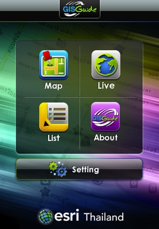
ความสามารถ
- แสดงภาพแผนที่เส้นทางคมนาคมครอบคลุม 77 จังหวัดในประเทศไทย
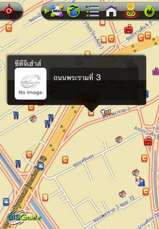
- แสดงตำแหน่งปัจจุบันของคุณ โดยอ่านค่าพิกัดจาก GPS
- แสดงตำแหน่งและรายละเอียดสถานที่สำคัญ (Points of Interest : POI)
- แยกหมวดหมู่สถานที่สำคัญด้วยไอคอนที่เข้าใจง่าย
- เปลี่ยนรูปแบบการมอง ระหว่างแผนที่ 2 มิติ และ Augmented Reality (AR)
- เปลี่ยนรูปแบบการมองเป็นแบบรายการ (List)
GIS Guide is copyright of ESRI (Thailand) Ltd., a provider of geographic information systems and the highest accuracy and quality basemap in Thailand. ESRI (Thailand) provides more than 600,000 POIs and 700,000 km of streets.
GIS Guide will allow you to enjoy Thailand Map with no cost. We developed GIS Guide by using Augmented Reality Technology to shows POIs on your iPhone screen and can be moved along with the camera in a different direction.
Features:
- Display Thailand Street Map cover 77 provinces.
- Display your current location by reading the coordinates from the built-in GPS.
- Display location and details of Points of Interest (POIs).
- Classification POIs by display icons that are easy to understand.
- 2-Dimensions map view / Augmented Reality map view
- POIs list view
Disclaimer:
AppAdvice does not own this application and only provides images and links contained in the iTunes Search API, to help our users find the best apps to download. If you are the developer of this app and would like your information removed, please send a request to takedown@appadvice.com and your information will be removed.
AppAdvice does not own this application and only provides images and links contained in the iTunes Search API, to help our users find the best apps to download. If you are the developer of this app and would like your information removed, please send a request to takedown@appadvice.com and your information will be removed.