You are using an outdated browser. Please
upgrade your browser to improve your experience.

coolAltitude is easy to use tool designed for IFR pilots to help them with calculations of temperature corrections during ILS (CATI), RNAV/GNSS, VOR and NDB approaches in cold weather

coolAltitude
by SilkIdea s.r.o.


What is it about?
coolAltitude is easy to use tool designed for IFR pilots to help them with calculations of temperature corrections during ILS (CATI), RNAV/GNSS, VOR and NDB approaches in cold weather. It can decode SNOWTAM reports from METAR information.
App Screenshots
App Store Description
coolAltitude is easy to use tool designed for IFR pilots to help them with calculations of temperature corrections during ILS (CATI), RNAV/GNSS, VOR and NDB approaches in cold weather. It can decode SNOWTAM reports from METAR information.
The strength of the tool lies in the amount of values you need to enter. Nobody is really willing to fill a lot of data to get simple calculation result. So the only data you need to enter are:
•Intermediate approach altitude
•Descent angle of the approach
•Minimums
•Runway elevation
•Height over the runway threshold
•And, of course, the temperature at the airport either in °C or °F
•MSA and Go Around altitudes, if required
•Optionally you may need to enter DME shift to work with DME’s offset from runway threshold.
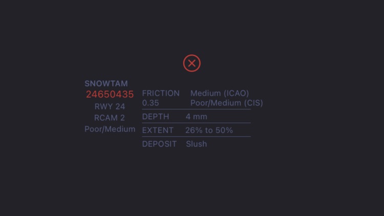
•Optionally SNOWTAM
As a reward for your effort you get in graphical and handy form:
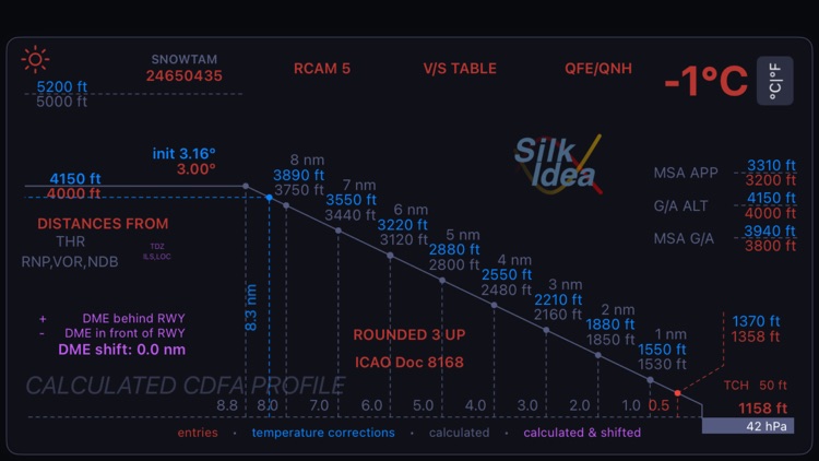
•Temperature corrected altitudes for all entered values
•Temperature corrected altitudes for altitudes above the intermediate approach altitude
•Temperature corrected altitudes for all relevant DME distances rounded in the way which makes them easy to use
•Temperature corrected descent angle for FPA enabled airplanes
•Pressure altitude of the airport in hectopascals
•Table with temperature corrected (and uncorrected) values of vertical speeds (ft/min) during descend for different ground speeds (kt)
•Table with conversion between QFE values in meters and QNH values in feet, of course with temperature corrected altitudes as well. All optimized for use in Russian regions
•Decoded SNOWTAM including braking actions based on friction coefficient according ICAO as well as Normative/CIS scales. It provides (experimental) recommendation for braking actions based on runway contaminant and airport temperature.
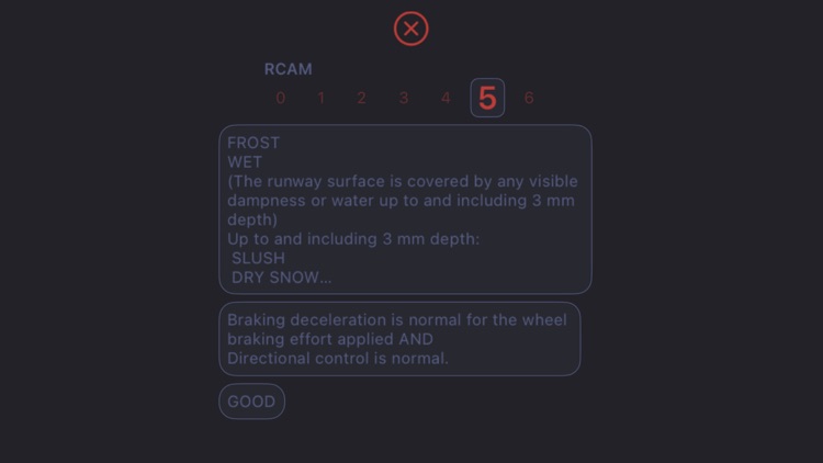
•RCAM - Runway Condition Assessment Matrix based on ICAO GRF – Global Reporting Format for Runway Surface Conditions.
Corresponding aviation authority can certify this tool. It must be the part of operator’s EFB package. Otherwise it cannot be used in real operations.
Disclaimer:
AppAdvice does not own this application and only provides images and links contained in the iTunes Search API, to help our users find the best apps to download. If you are the developer of this app and would like your information removed, please send a request to takedown@appadvice.com and your information will be removed.
AppAdvice does not own this application and only provides images and links contained in the iTunes Search API, to help our users find the best apps to download. If you are the developer of this app and would like your information removed, please send a request to takedown@appadvice.com and your information will be removed.