You are using an outdated browser. Please
upgrade your browser to improve your experience.
FR - Calendrier des chasses et travaux en forêt en géolocalisation

Forest Secure
by L'App du Terroir


What is it about?
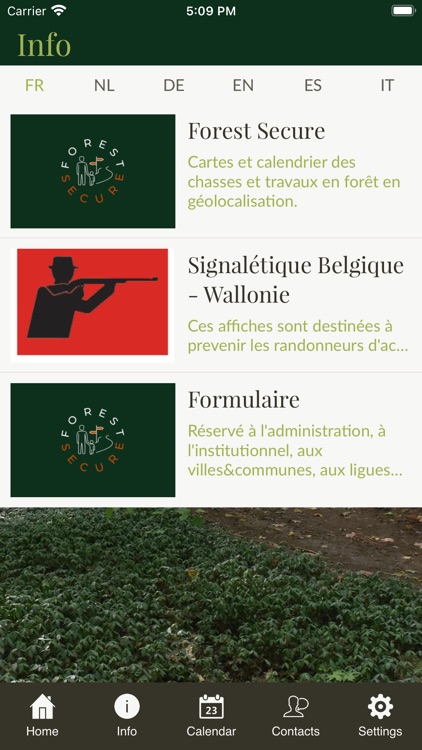
FR - Calendrier des chasses et travaux en forêt en géolocalisation. Les lieux de chasse et des travaux en forêt sont identifiés sur une carte interactive ou sur une liste par date. Les randonneurs sont informés des dangers et peuvent planifier leurs ballades en toute sécurité. Zones interdites au public : Une notification automatique est envoyée à la personne qui pénètre dans une zone de danger.
App Screenshots

App Store Description
FR - Calendrier des chasses et travaux en forêt en géolocalisation. Les lieux de chasse et des travaux en forêt sont identifiés sur une carte interactive ou sur une liste par date. Les randonneurs sont informés des dangers et peuvent planifier leurs ballades en toute sécurité. Zones interdites au public : Une notification automatique est envoyée à la personne qui pénètre dans une zone de danger.
Vous trouverez dans l'application mobile Forest Secure :
1. Infos disponibles en FR - NL - DE - EN - ES - IT : Application mobile Forest Secure. Signalétiques spécifiques
2. Calendrier avec géolocalisation : Les dates et lieux des chasses, battues et travaux en forêt.
3. Alertes : Les lieux dangereux sont identifiés (chasses, travaux en forêt, lieux interdits au public) et bénéficient de geofence's. Lorsque vous pénétrez dans une zone de danger, vous recevez une notification vous invitant à être vigilant.
4. Contacts avec géolocalisation : Coordonnées de l'administration et des clubs de chasse.
NL - Kalender van jagen en werken in het bos in geolocatie. Jacht- en boswerkplaatsen worden geïdentificeerd op een interactieve kaart of op een lijst op datum. Wandelaars zijn op de hoogte van de gevaren en kunnen hun wandelingen in alle veiligheid plannen. Publieke verboden zones: Er wordt automatisch een melding gestuurd naar de persoon die een gevarenzone betreedt.
U vindt in de Forest Secure mobiele applicatie:
1. Info beschikbaar in FR - NL - DE - EN - ES - IT : Forest Secure mobiele app. Specifieke tekens
2. Kalender met geolocatie : De data en plaatsen van de jacht, mishandeling en werk in het bos.
3. Waarschuwingen : Gevaarlijke plaatsen worden geïdentificeerd (jagen, werken in het bos, plaatsen gesloten voor het publiek) en profiteren van geofence's. Wanneer u een gevarenzone betreedt, ontvangt u een melding waarin u wordt aangespoord waakzaam te zijn.
4. Contacten met geolocatie : Contactgegevens voor de administratie en jachtverenigingen.
DE - Kalender der Jagd und Arbeit im Wald in der Geolokalisierung. Jagd- und Forstarbeitsplätze sind auf einer interaktiven Karte oder in einer Liste nach Datum gekennzeichnet. Wanderer werden über die Gefahren informiert und können ihre Wanderungen in absoluter Sicherheit planen. Öffentliche verbotene Zonen: Eine automatische Benachrichtigung wird an die Person gesendet, die eine Gefahrenzone betritt.
In der mobilen Anwendung Forest Secure finden Sie:
1. Info verfügbar in FR - NL - DE - EN - ES - IT : Forest Secure-App für Mobilgeräte. Spezifische Zeichen
2. Kalender mit Geolokalisierung : Die Daten und Orte der Jagden, Schläge und Arbeiten im Wald.
3. Benachrichtigungen : Gefährliche Orte werden identifiziert (Jagd, Arbeit im Wald, für die Öffentlichkeit gesperrte Orte) und profitieren von Geofence's. Wenn Sie eine Gefahrenzone betreten, erhalten Sie eine Benachrichtigung, die Sie auffordert, wachsam zu sein.
4. Kontakte mit Geolocation : Kontaktdaten der Verwaltung und Jagdvereine.
EN - Calendar of hunting and work in the forest in geolocation. Hunting and forest work sites are identified on an interactive map or on a list by date. Hikers are informed of the dangers and can plan their walks in complete safety. Public forbidden zones: An automatic notification is sent to the person who enters a danger zone.
You will find in the Forest Secure mobile application:
1. Info available in FR - NL - DE - EN - ES - IT : Forest Secure mobile app. Specific signs
2. Calendar with geolocation : The dates and places of the hunts, beatings and work in the forest.
3. Alerts : Dangerous places are identified (hunting, work in the forest, places closed to the public) and benefit from geofence's. When you enter a danger zone, you will receive a notification urging you to be vigilant.
4. Contacts with geolocation : Contact details for the administration and hunting clubs.
L'utilisation continue du GPS en arrière-plan peut réduire considérablement la durée de vie de la batterie.
Disclaimer:
AppAdvice does not own this application and only provides images and links contained in the iTunes Search API, to help our users find the best apps to download. If you are the developer of this app and would like your information removed, please send a request to takedown@appadvice.com and your information will be removed.
AppAdvice does not own this application and only provides images and links contained in the iTunes Search API, to help our users find the best apps to download. If you are the developer of this app and would like your information removed, please send a request to takedown@appadvice.com and your information will be removed.