You are using an outdated browser. Please
upgrade your browser to improve your experience.

The GPS Field Area Measure app is a versatile tool designed for users who need accurate measurements of land, fields, or any area on a map

GPS Field & Land Area Measure
by Growup Infosoft

What is it about?
The GPS Field Area Measure app is a versatile tool designed for users who need accurate measurements of land, fields, or any area on a map.
App Screenshots


App Store Description
The GPS Field Area Measure app is a versatile tool designed for users who need accurate measurements of land, fields, or any area on a map.
It provides a simple way to easily calculate any area or distance between two places with the GPS Field & Land Area Measure app.
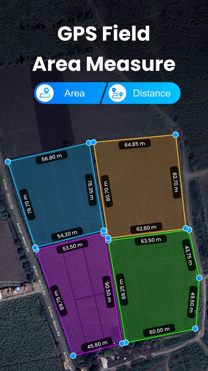
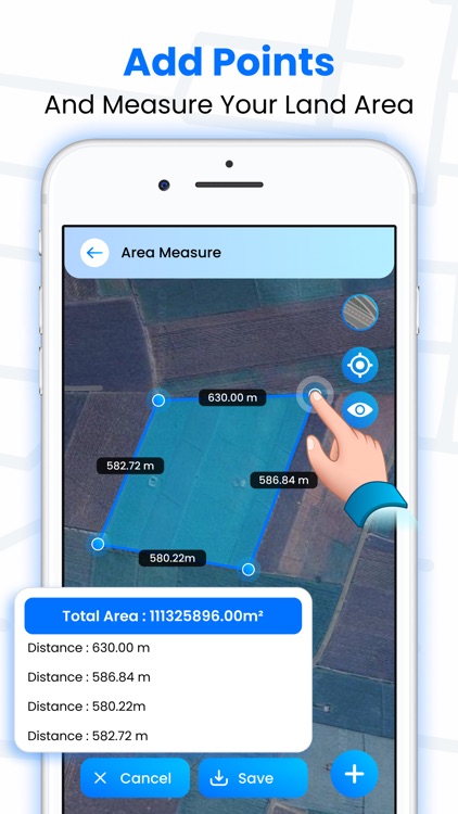
This app is a smart tool for measuring areas on the map. Once you place your points on the map, calculate the area between all the points.
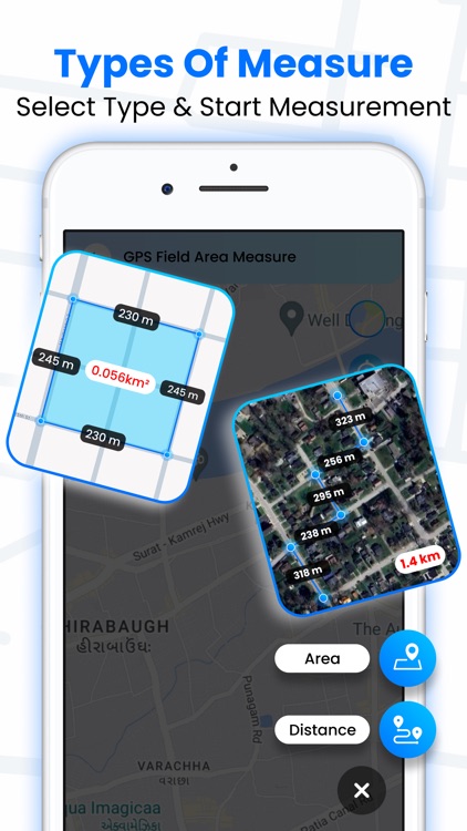
With this app, you can also calculate the distance between different places.
GPS Field & Land Area Measure helps you calculate GPS area or GPS distance with great accuracy.
The GPS Field & Land Area Measure app is very simple and easy to use for everyone.
GPS Field & Land Area Measure is useful for people living in villages and also in cities. This GPS app allows you to calculate an area on a map.
With this app, you can also save all your measured data into the app gallery with your choice of name group and tag color.
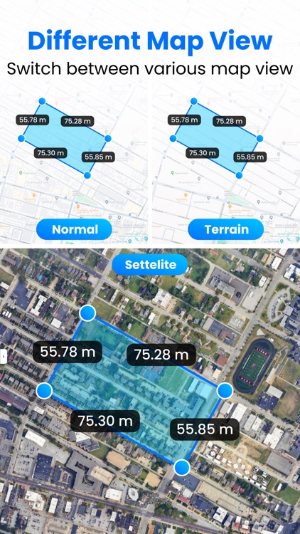
Use different types of map types and enhance your area calculation easily.
Features
- Easily calculate areas by tapping on the map.
- Measure fields effortlessly.
- Switch between different map types: Hybrid, Terrain, Satellite, or Normal.
- Choose from a wide range of distance units, including inches, feet, yards, miles, millimeters, and more.
- Select from various area units, such as square inches, square feet, square yards, square miles, acres, meters, and more. the map with ease.
- Find your current location instantly.
- Calculate distances accurately using coordinates.
- Smartly measure areas with precision.
- Place and adjust pins quickly and accurately.
- Convert measured areas and distances into any units you prefer.
- Save all your measurements for future reference in a saved list.
Plans are here to make the app premium:
GPS Field One Wee - 5.99
GPS Field One Year - 44.99
Your payment will be charged to your iTunes Account as soon as you confirm your purchase.
For more information:
Privacy - http://growupinfosoft.com/pages/Policy.html
Terms of use - http://growupinfosoft.com/pages/Terms_Of_Use.html
Disclaimer:
AppAdvice does not own this application and only provides images and links contained in the iTunes Search API, to help our users find the best apps to download. If you are the developer of this app and would like your information removed, please send a request to takedown@appadvice.com and your information will be removed.
AppAdvice does not own this application and only provides images and links contained in the iTunes Search API, to help our users find the best apps to download. If you are the developer of this app and would like your information removed, please send a request to takedown@appadvice.com and your information will be removed.