You are using an outdated browser. Please
upgrade your browser to improve your experience.
This App offers access to HD Marine Charts for USA,Canada,UK/Ireland,Germany,Netherlands/Holland &

i-Boating:HD Gps Marine Charts
by Bist LLC
What is it about?
This App offers access to HD Marine Charts for USA,Canada,UK/Ireland,Germany,Netherlands/Holland &
i-Boating:HD Gps Marine Charts is FREE but there are more add-ons
-
$19.99
USA - HD Marine & Fishing Maps
-
$24.99
Canada & USA - HD Boating and Fishing Maps
App Screenshots
App Store Description
This App offers access to HD Marine Charts for USA,Canada,UK/Ireland,Germany,Netherlands/Holland &
Europe Rivers (Danube,Drava,Rhein etc). Coverage includes NOAA marine vector charts,freshwater lake maps,USACE inland river maps (HD/1ft/3ft bathymetry
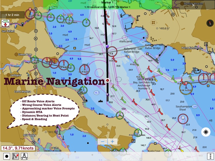
included where available),charts derived from UKHO & CHS data. First marine GPS app to have route assistance with Voice Prompts for marine navigation. You can create new boating routes or import existing GPX/KML routes. It supports Nautical Charts course up orientation. Includes Tide & Currents prediction.
►FEATURES
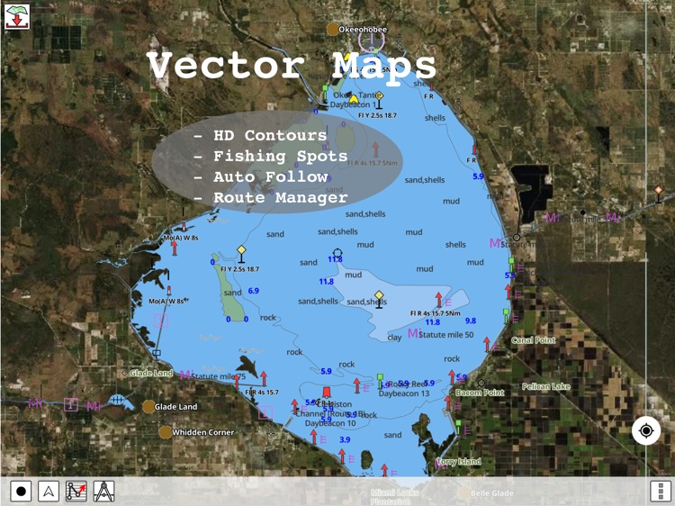
√ Beautiful & detailed Hardware/GPU accelerated vector charts (text stays upright on rotation)
√ Long press to query the details of Marine object (Buoy,Lights,Obstruction etc).
√ Customizable depth(Ft/Fathom/Meter) & distance units(km/mi/NM)
√ Customizable Shallow Depth.
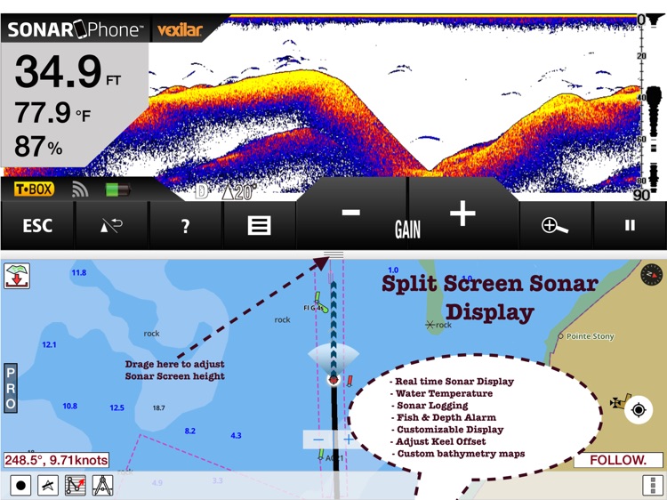
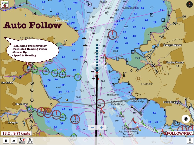
√ Record tracks,Autofollow with real-time track overlay & predicted path vector.
√ Voice Prompts for marine navigation (requires GPS )
√ 1ft / 3ft depth contour maps for anglers for selected lake maps.
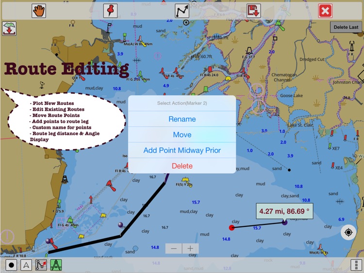
√ Supports GPX/KML for boating route editing/import.
√ Tide & Currents prediction.
√ Seamless chart quilting of marine charts
√ Enter or import Waypoints.
► MAPS
It includes unlimited updates for 1 year.
√USA: The maps include coverage of all NOAA marine vector charts (ENC),USACE inland river maps,freshwater lake maps for more than 7K lakes. The charts include HD/1ft/3ft bathymetry where available.Incl. NOAA raster where ENC not available.
√Canada:Incl. CHS data(incl. major Lakes).
√UK/Ireland: Derived from UKHO charts.
√Australia
√Germany: derived from BSH data.
√Europe Inland Rivers:Donau/Dunaja,Rhine,Garonne,Moselle,Drava,Sava,etc
√Norway
√Finland
√Sweden
√Croatia
√Ukraine(Black Sea)
√Caribbean
√New Zealand
√Spain
√Brazil
√Argentina
√Cyprus
√Falklands
√Seychelles& Mauritius
√Denmark
√Malta,Cyprus & S. Mediterranean
√S. China&Malaysia
√South Africa
►ROUTE MANAGEMENT / TRIP PLANNING
√ Create New Route/Edit Existing Routes
√ Move Points
√ Add points to an existing route leg
√ Delete / Rename points
√ Import GPX,KML & KMZ files
√ Plot/Edit Routes
√ Enter Waypoints
√ Share/Export Routes,Tracks&Markers
√ Reverse Routes
►GPS FEATURES
√ Auto Follow
* Real Time Track Overlay
* Predicted Path Vector
* Course Up(Text stays upright)
* Speed & Heading
√ Route Assistance With Voice Prompts
* Prompts when approaching a boating route marker
* Continous distance & ETA updates
* Alerts when sailing/boating off route
* Alerts when boating in wrong direction
√ Record Tracks
►TIDE & CURRENTS
* For US, Canada, UK, Germany & New Zealand
* High/Low Tides
* Tidal Current Prediction
* Active Current Stations
► SHARING
* Share tracks/routes/markers on Facebook & Twitter
* Export tracks/routes/markers as compressed GPX files.
Sample Charts
SUGARLOAF KEY-KEY WEST
PORT RICHEY TAMPA BAY - CLEARWATER HBR
EAST BAY-WEST BAY FLORIDA
ST JOSEPH,ST ANDREW BAYS
INTRACOASTAL WATERWAY MATECUMBE-GRASSY KEY
CHESAPEAKE BAY CAPE CHARLES-NORFOLK HARBOR
ANCLOTE KEYS-CRYSTAL RIVER
ST JOSEPH SOUND
MIAMI HARBOR
Minnesota lakes - Kabetogama,Minnetonka,Waconia,Leech,Mille Lacs
Lake Keowee,Jocassee,Hartwell,Greenwood,Lake Murray
Mark Twain,Ozarks,Table Rock
Lake St.Clair
Lake Kentucky
KEY WEST-THE MISSISSIPPI RIVER
SAN PEDRO CHANNEL
LAKE MICHIGAN STONY LAKE-POINT BETSIE
APALACHICOLA BAY-CAPE SAN BLAS
EAST CAPE-MORMON KEY
CAPE HENLOPEN-INDIAN RIVER
CHESAPEAKE BAY CAPE HENRY-THIMBLE SHOAL LIGHT
DULUTH-SUPERIOR
MONHEGAN ISLAND-CAPE ELIZABETH
ONTARIO - CLAYTON-FALSE DUCKS ISL
Winnipesaukee
MIAMI-MARATHON,FLORIDA BAY
CAPE MAY-FENWICK ISLAND
MISSISSIPPI RIVER-GALVESTON
CAPE CANAVERAL-KEY WEST
DELAWARE RIVER WILMINGTON-PHILADELPHIA
FLORIDA KEYS SOMBRERO KEY-SAND KEY
SAN PABLO BAY
RAINY LAKE BIG ISLAND MINN-OAKPOINT ISL ONT
INTRACOASTAL WATERWAY - BISCAYNE BAY
EVERGLADES NTL PARK - SHARK RVR-LOSTMANS
HURON
TAHOE
CHESAPEAKE DELAWARE CANAL
PLEASE NOTE: Continued GPS running in background can dramatically decrease battery life.
Disclaimer:
AppAdvice does not own this application and only provides images and links contained in the iTunes Search API, to help our users find the best apps to download. If you are the developer of this app and would like your information removed, please send a request to takedown@appadvice.com and your information will be removed.
AppAdvice does not own this application and only provides images and links contained in the iTunes Search API, to help our users find the best apps to download. If you are the developer of this app and would like your information removed, please send a request to takedown@appadvice.com and your information will be removed.