You are using an outdated browser. Please
upgrade your browser to improve your experience.
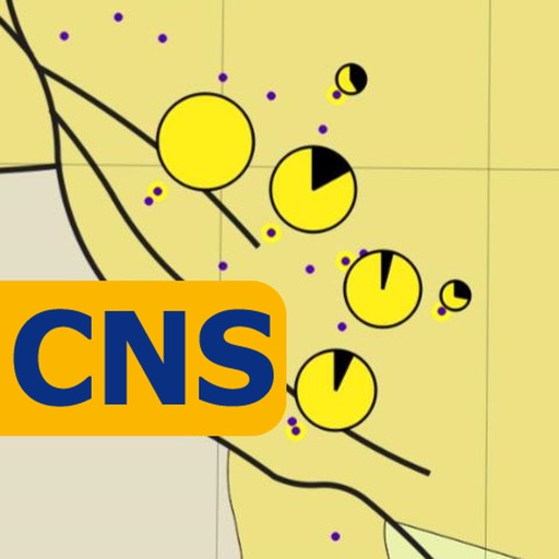
CNS Atlas - Maps & Statistics for Reservoir Characterisation

oilFinder CNS
by Geop4ysics Ltd

What is it about?
CNS Atlas - Maps & Statistics for Reservoir Characterisation
App Screenshots
App Store Description
CNS Atlas - Maps & Statistics for Reservoir Characterisation
INFO
oilFinder CNS - CNS Atlas app presents a set of 46 regional geological maps for the Central North Sea and Moray Firth areas of the UKCS for Jurassic, Cretaceous, Paleocene and Eocene periods. The app is a highly convenient, user friendly tool to assist in defining exploration opportunities and geological play fairways. It is ideal for data-rooms, peer reviews or simply a convenient tool to assist with exploration workflows.
The maps were generated using open source data from the UK Oil and Gas Authority (OGA) compiled by Lloyd’s Register, with additional third party data.
© Contains public sector information licensed under the Open Government Licence v3.0
MAIN FEATURES
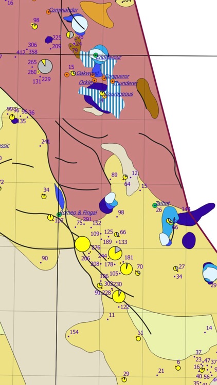
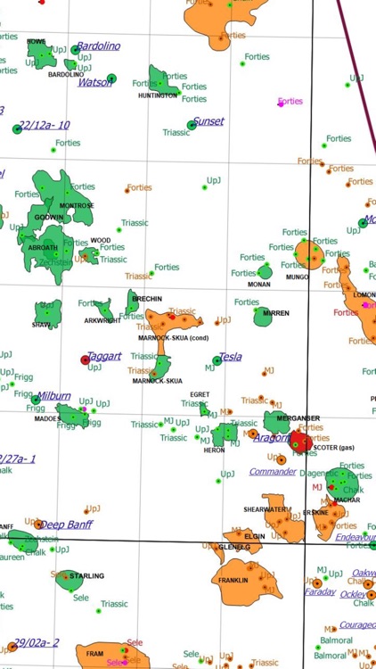
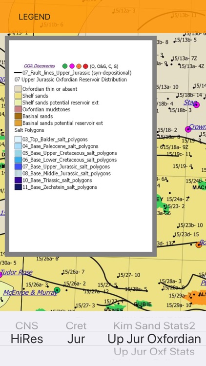
Maps presented in the atlas are reservoir facies distribution, structural elements, sand statistics, hydrocarbon occurrences and stratigraphy at well TD. Undeveloped Discoveries (called OGA Discoveries) are also displayed. The information was processed in a GIS application in CRS: ED50 UTM Zone 31 N.
USEFUL TIPS
Maps are displayed with the ability to magnify. The app is available as both iPad and iPhone versions. It works offline.
Tap the screen to hide the menu: LEGEND, INFO, HELP.
WORKING WITH OGA LR REGIONAL MAPS AND SAND STATISTICS:
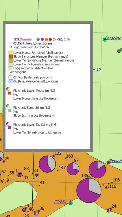
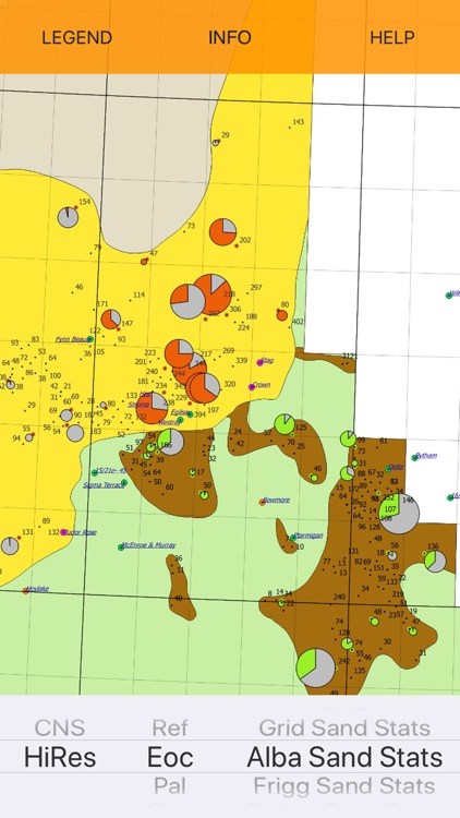
Two map types are presented: Regional reservoir facies maps and Sand statistics maps. Sand statistics are plotted on to reservoir facies maps, giving greater detail on reservoir attractiveness.
Sand statistics are presented as Net/Gross pie charts. Note that the N/G ratio is not available in all wells. Gross thickness is graphically represented by the size of the individual pie chart, although wells with very thin packages have had to be increased in size to allow visualisation. The gross thickness is also displayed as a number at well locations.
The app presents a hydrocarbon map with all hydrocarbon occurrences from the OGA LR database.
The TD Wells map helps to identify areas & stratigraphic intervals not penetrated by wells.
Both hydrocarbons and TD Wells maps are available under the Ref (References) option.
CHOICE OPTIONS UNDER THE LEFT WHEEL ARE CNS AND HiRes:
CNS: displays regional maps for the Moray Firth and Central North Sea, suitable for a general overview with larger fonts and symbols, and gives the possibility to magnify up to 5 times.
HiRes: presents high resolution maps designed for looking in greater detail at specific blocks, with the possibility to magnify up to 15 times.
CHOICE OPTIONS UNDER THE MIDDLE WHEEL ARE:
Ref – References, Eoc - Eocene, Pal - Paleocene, Cret - Cretaceous, Jur – Jurassic
Maps are grouped by period for both CNS (lower resolution) and HiRes settings.
CHOICE OPTIONS UNDER THE RIGHT WHEEL ARE:
Reservoir facies distribution maps, Sand statistics (N:G) & thickness for chosen stratigraphic intervals, as follows:
Eoc: Grid, Alba, Frigg, Balder, Cromarty, Forties
Pal: Balmoral, Andrew, Maureen
Cret: Upper Cretaceous, Lower Cretaceous Aptian, Valanginian-Barremian
Jur: Kimmeridgian, Oxfordian, Callovian, Bathonian, Lower Jurassic.
REF OPTION SETTINGS ON THE RIGHT WHEEL ARE:
Hydrocarbons - presents all hydrocarbon occurrences from OGA LR open source data
Source Rocks - presents Kimmeridgian Clay and Devonian source rocks distribution
TD Well - displays stratigraphy at well TD.
TERMS OF SERVICE
These maps were created on a best effort basis and every effort is made to ensure the information is correct, however, Geop4ysics Ltd and their directors and associates do not accept any liability for loss or damage which may be sustained as a result of reliance upon such information. The material displayed on our service is provided without guarantees, conditions or warranties as to its accuracy. Recipients should rely solely on their own judgement, review and analysis.
If you have any questions please contact us at: kinga@4geopro.com
Copyright © 2018 Geop4ysics Ltd
www.4geopro.com
Disclaimer:
AppAdvice does not own this application and only provides images and links contained in the iTunes Search API, to help our users find the best apps to download. If you are the developer of this app and would like your information removed, please send a request to takedown@appadvice.com and your information will be removed.
AppAdvice does not own this application and only provides images and links contained in the iTunes Search API, to help our users find the best apps to download. If you are the developer of this app and would like your information removed, please send a request to takedown@appadvice.com and your information will be removed.