You are using an outdated browser. Please
upgrade your browser to improve your experience.
This has a low-cost ANNUAL subscription - with a 1-week FREE trial - details below

Ontario field geology maps
by David Collins
What is it about?
This has a low-cost ANNUAL subscription - with a 1-week FREE trial - details below.
App Store Description
This has a low-cost ANNUAL subscription - with a 1-week FREE trial - details below.
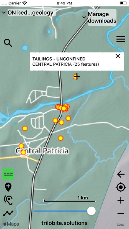
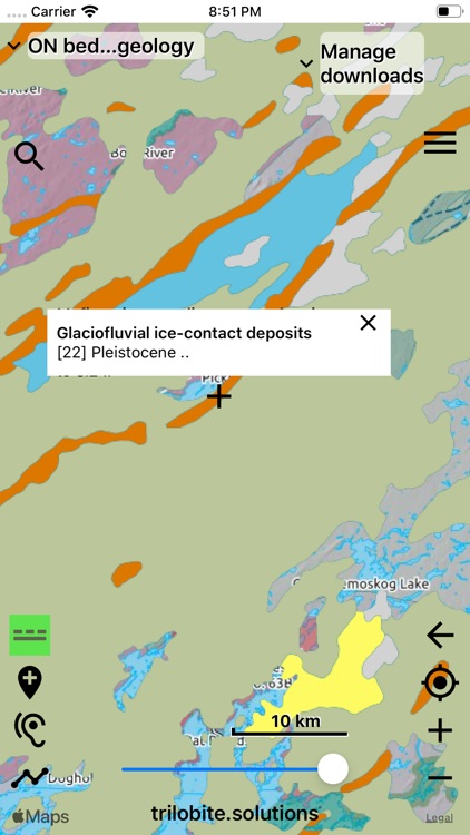
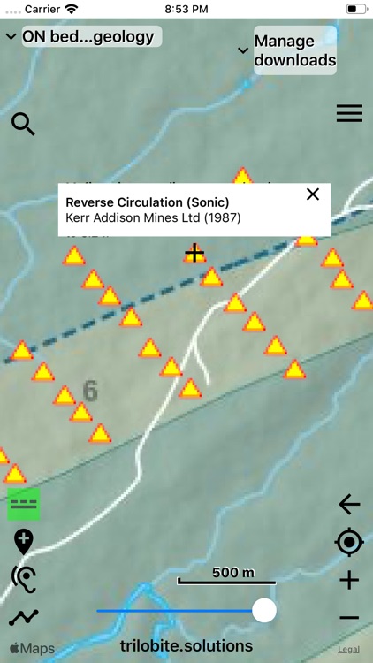
Ontario prospector is a field app that displays the best available data from the Ontario geological survey in interactive maps created by Trilobite Solutions. It does not have any reliance on cell phone reception in the field, and uses GPS so your location is always marked on the map. Maps are downloaded to your phone when have an internet connection, and from that point on, you are independent of the internet.
The base geology maps are rich with contextual data - including shaded relief, roads, towns, tracks, rivers, lakes, geographic names, indigenous land, national parks & provincial parks.
App development, system maintenance and user support is fully-funded by subscriptions - there is no in-app advertising and your data is absolutely PRIVATE.
ANNUAL App subscription
- $11.99 for Canadians (1-week FREE trial)
- required by ALL app users to run the app
• bedrock geology
• quaternary geology
• symbolised resource map
• color aero-magnetics imagery
• recorded locations for copper, iron, uranium, zinc, molybdenum, silver, nickel, limestone, granite, peat, mica, salt, magnetite, gravel, building stone, oil shale, cobalt, corundum, diamond, gems, mineral specimens
• record your trails and write notes on marked locations
• geology is spoken when you cross a boundary while driving
• overlay any map semi-transparently over any other map
• export trails and marked locations to Google Earth or your GIS
• import trails and marked locations from Google Earth
• import geojson data and mbtiles maps (videos on web-site)
ANNUAL Professional subscription
- $11.99 for Canadians (1-week FREE trial)
- access to specialised prospecting maps
• map of gold resources
• abandoned mines map
• drill holes overlay
• mining tenure & claims map - updated each working day (at noon)
Each subscription covers all of your iPhones and iPads.
When in the field, please PUT YOUR PHONE INTO FLIGHT MODE. This greatly extends your phone's battery life.
Warning: iPads without SIM sockets do not have GPS hardware, so will not determine your location in the field.
Terms of Use: http://trilobite.solutions/maps/terms/
Trial and subscriptions details:
• Payment will be charged to your iTunes Account at the end of the 1-week trial period, unless you cancel your subscription at least 24 hours before the trial has finished, in which case NO MONEY LEAVES YOUR ACCOUNT
• Subscription automatically renews each year unless auto-renew is turned off at least 24-hours before the end of the current subscription period
• Your account will be charged for renewal within 24-hours prior to the end of the current subscription period
• Subscriptions may be managed by you, and auto-renewal may be turned off within the Settings app on your iPhone/iPad
Disclaimer:
AppAdvice does not own this application and only provides images and links contained in the iTunes Search API, to help our users find the best apps to download. If you are the developer of this app and would like your information removed, please send a request to takedown@appadvice.com and your information will be removed.
AppAdvice does not own this application and only provides images and links contained in the iTunes Search API, to help our users find the best apps to download. If you are the developer of this app and would like your information removed, please send a request to takedown@appadvice.com and your information will be removed.