You are using an outdated browser. Please
upgrade your browser to improve your experience.
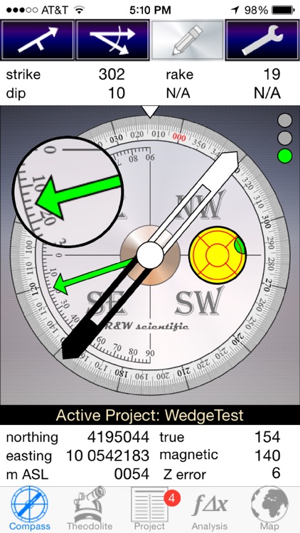
PocketTransit Pro records the orientations of planes and lines, traverse distances and angles, field site locations, photographs with metadata, and more

PocketTransit
by Thomas Redfield
What is it about?
PocketTransit Pro records the orientations of planes and lines, traverse distances and angles, field site locations, photographs with metadata, and more. Built for professional use by geologists, geophysicists, surveyors, and field/mining engineers, PocketTransit Pro allows easy email export of data to spreadsheet-compatible file format.
App Store Description
PocketTransit Pro records the orientations of planes and lines, traverse distances and angles, field site locations, photographs with metadata, and more. Built for professional use by geologists, geophysicists, surveyors, and field/mining engineers, PocketTransit Pro allows easy email export of data to spreadsheet-compatible file format.
PocketTransit Pro is optimized for the iPhone 5 or 6 but can be installed on the iPhone 4S.
The PocketTransit Pro data interface permits customization of data types by individual users and easy email export to a spreadsheet-compatible file format.
PocketTransit Pro:
Mimics a traditional geological compass.
Compass, GPS-based Theodolite, Project, Analysis, and Map functions.
Project-based storage of Compass, Theodolite, Waypoint/Locality and Photo records, with appropriate metadata.
Email export of Project data (including Photo Records) and Stereonet images.
Map display of data.
Customization of plane and line categories (F1, S1, Fold Axis, etc).
Plane and line measurements recorded in the same record structure, with optional kinematic lineation sense (up, down, unknown).
Live data display.
Equal angle and equal area stereonets, and normalized rose diagrams.
Data-type or data-quality based color classification in stereonet display.
Simple kinematic analysis functions (plane, wedge, and toppling).
Navigation to mapped localities.
Getting Started Info found on Compass Settings page (About PocketTransit Pro).
WARNING: All smartphones create a strong magnetic field which must be properly calibrated lest the measured data be compromised. Test your smartphone under controlled circumstances to understand its individual response. PocketTransit Pro is not a subsititute for geological field experience and proper geological training!
Disclaimer:
AppAdvice does not own this application and only provides images and links contained in the iTunes Search API, to help our users find the best apps to download. If you are the developer of this app and would like your information removed, please send a request to takedown@appadvice.com and your information will be removed.
AppAdvice does not own this application and only provides images and links contained in the iTunes Search API, to help our users find the best apps to download. If you are the developer of this app and would like your information removed, please send a request to takedown@appadvice.com and your information will be removed.