You are using an outdated browser. Please
upgrade your browser to improve your experience.

Be prepared

Yosemite Pocket Maps
by Alex Gugel


What is it about?
Be prepared! Plan your next trip to the Yosemite national park area. Download maps and guides before you venture into the Wi-Fi free wilderness.
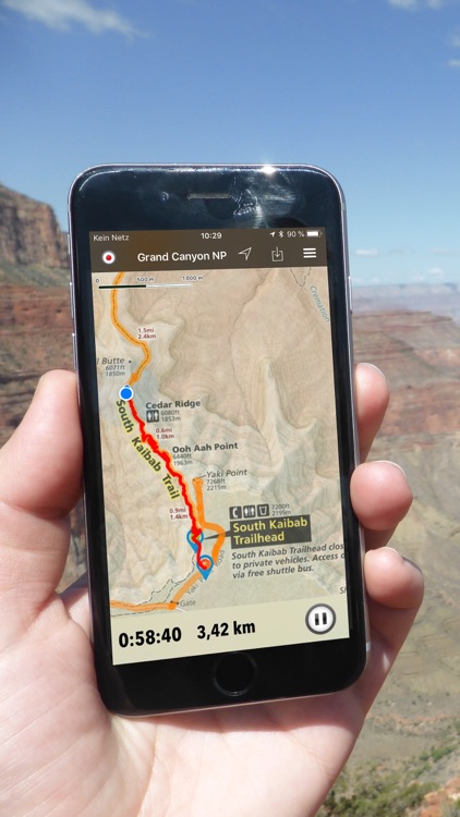
App Screenshots


App Store Description
Be prepared! Plan your next trip to the Yosemite national park area. Download maps and guides before you venture into the Wi-Fi free wilderness.
Discover
- 15+ national parks, state parks, monuments, forests
- 110+ neatly folded maps by the National Park Service, Bureau of Land Management, United States Forest Services, and other agencies.
- Complete USGS 7.5 minutes topo maps coverage for Yosemite National Park and Devils Postpile National Monument.
- Motor Vehicle Use Maps (MVUM), Motor Vehicle Travel Maps (MVTM) and visitor maps for national forests.
- 2,200+ campgrounds and campsites
- 2,100+ trails and trailheads
- 150,000+ points of interests
Plan
- Download maps, park brochures, and newspapers. These downloads are ready when you are offline and off the grid in the great outdoors.
- Download arbitrary map sections as offline packs.
- Photo galleries, panorama views.
- Share links to parks and maps with friends
Have fun
- GPS and GPX support: record your hikes, import GPX routes, tracks and waypoints for your hiking trails.
- Detailed national park information: alerts, news, visitor centers, campgrounds, driving directions, weather.
- Open your favorite maps app to get a route to the selected park.
- Current weather conditions, easy access to multi-day forecasts, sunrise and sunset times.
- Push notifications for park alerts, park news, weather warnings
So download maps and guides for:
National Parks
- Yosemite National Park
- Devils Postpile National Monument
National Forests
- Humboldt-Toiyabe
- Inyo
- Sierra
- Stanislaus
State Parks and other areas
- Bodie
- Calaveras Big Trees
- California State Mining and Mineral Museum
- Columbia
- Grover Hot Springs
- Mammoth Lakes
- Mono Lake Tufa
- Railtown 1897
- Wassama Round House
-
GPS
- Continued use of GPS running in the background can dramatically decrease battery life.
LEGAL
Terms of Use: https://www.icoat.de/pocketmaps/terms
Privacy Policy: https://www.icoat.de/pocketmaps/privacy
Disclaimer:
AppAdvice does not own this application and only provides images and links contained in the iTunes Search API, to help our users find the best apps to download. If you are the developer of this app and would like your information removed, please send a request to takedown@appadvice.com and your information will be removed.
AppAdvice does not own this application and only provides images and links contained in the iTunes Search API, to help our users find the best apps to download. If you are the developer of this app and would like your information removed, please send a request to takedown@appadvice.com and your information will be removed.