You are using an outdated browser. Please
upgrade your browser to improve your experience.

●Description

地図と測量の科学館 モバイルガイドサービス
by UC Technology Corporation
What is it about?
●Description
App Store Description
●Description
"The Science Museum of Map and Survey Mobile Guide Service" is an official application program to guide each exhibition area in The Science Museum of Map and Survey, and exhibited items such as maps and survey instruments in an easy-to-understand manner by the voice and movie on smartphones and tablet devices.
The Science Museum of Map and Survey Mobile Guide Service" is composed of two services: "Introduction of the exhibition area" that guides you in the exhibition area automatically and "Introduction of the exhibit" that explains the exhibit items reading IC tags with QR Code installed inside the building. You can learn the details of the exhibition areas and the exhibits of "The Science Museum of Map and Survey."
This application program identifies the location of the exhibition areas and exhibits by using location information code that Geospatial Information Authority of Japan has developed.
●How to use
Let's walk on a Japanese map on the ground floor of the Science Museum of Map and Survey.
The guide of the five regions is displayed automatically when you walk on the Japanese map on the ground floor after starting the App. Let's hear the introduction of the five regions.
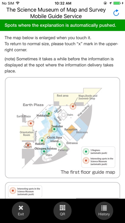
The exhibition areas in the museum are automatically guided.
The surrounding exhibition area of 10 interesting spots in the Science Museum is automatically explained when you reach there.
Let's see the detailed explanations of the exhibits in the museum.
You can read the detailed explanation of the exhibit when you scan IC tags or read QR Codes installed in many places of the museum.
Automatic guide to the interesting spots in Earth Plaza
Five exhibits outside the Science Museum are also guided automatically. Let's go out of the Science Museum, and walk in Earth Plaza.
●Operating conditions
・You can use this App and service if your device is iPhone4S (or later version) in which iOS7.0 or a later version is installed.
・It is necessary to turn Bluetooth and GPS "ON" to recognize the exhibition area.
・The iOS version cannot read the IC tag in a non-contact manner because NFC is not supported. Use "Introduction of the exhibit" service by optically scanning the QR Code printed on the IC tag.
・Only Japanese and English are supported with this application program. Other languages are not supported.
●"kokosil”
・This application program and the service use the kokosil service of Ubiquitous Computing Technology Corporation.
・kokosil is a general-purpose platform to offer information such as “Strolling in town” and “Sightseeing.”
・kokosil has been used in Ginza, Komae, Nasushiobara, Aizuwakamatsu, Yokohama Port Museum and HARA Model Railway Museum, and will be used across Japan.
・Audio tour guidance, events such as stamp rallies, and photography contests that are tuned to the events taking place in towns and places can be supported, too.
・See the following website for details.
http://kokosil.net
http://ts.uctec.com/uctec/jp/kokosil/index.php
Disclaimer:
AppAdvice does not own this application and only provides images and links contained in the iTunes Search API, to help our users find the best apps to download. If you are the developer of this app and would like your information removed, please send a request to takedown@appadvice.com and your information will be removed.
AppAdvice does not own this application and only provides images and links contained in the iTunes Search API, to help our users find the best apps to download. If you are the developer of this app and would like your information removed, please send a request to takedown@appadvice.com and your information will be removed.