You are using an outdated browser. Please
upgrade your browser to improve your experience.
An app to satisfy all your Fishing's needs, developed with the help of professional fishermen

Aqua Map Lakes - Fishing Chart
by GEC s.r.l.
What is it about?
An app to satisfy all your Fishing's needs, developed with the help of professional fishermen. You will be able to download the best maps and enjoy your new fishing season. Press the RECORD button, put the phone in your pocket and record your fishing trolling track....and much more.
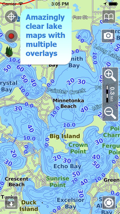
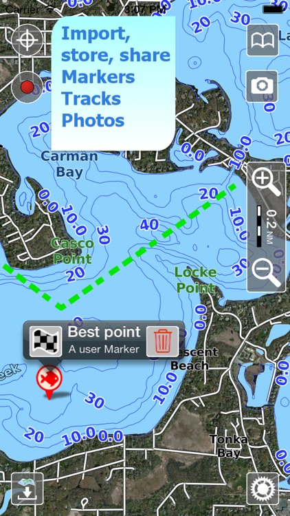
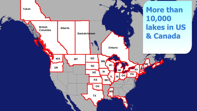
App Screenshots

App Store Description
An app to satisfy all your Fishing's needs, developed with the help of professional fishermen. You will be able to download the best maps and enjoy your new fishing season. Press the RECORD button, put the phone in your pocket and record your fishing trolling track....and much more.
►► Features:
• Optimised for both iPhone and iPad use
• You will have a 2 weeks FREE period to download and check ALL our lakes
• Over 10000 lakes for US & Canada, plus a complete topographic map with offroad trails to reach the most remote lakes and rivers
• Amazingly clear fishing charts
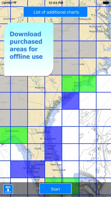
• Download the maps on the device, to be used later offline without any internet connection
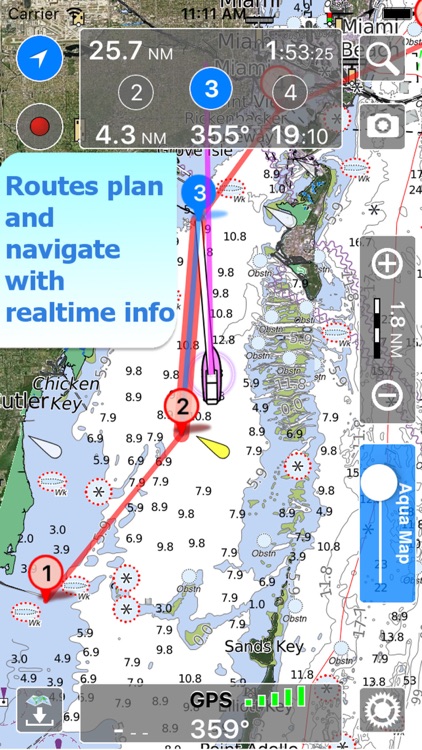
• Plan and navigate your ROUTE
• NEW - Anchor alarm with advanced configuration
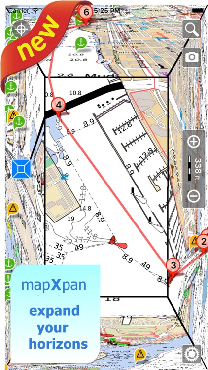
• Expand your horizons with mapXpan (patent pending)
• ActiveCaptain community integration
• Waterway Guide POIs integration
• Optimized battery usage; up to 14 hours continuous track
• Add the Satellite images as overlay of your maps
• Share and load tracks, markers, routes and pictures in various formats (KMZ and GPX)
• Store an unlimited number of tracks, markers and routes
• Customize your Markers, Tracks and Routes color and icon
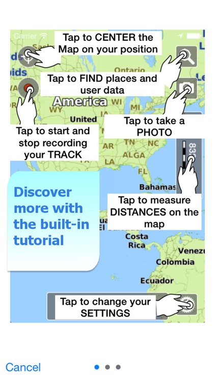
• Query map objects with your finger tip
► MAPS
Aqua Map lets you download maps with depth contours, boat ramps, etc. but also a complete Topographic map with road network, trails, elevation contours, lakes, rivers, etc. and all it is necessary to enjoy your best fishing experience. You can download the maps at home within your device and then use them on the boat without any Internet connection.
► ANCHOR ALARM
This function will check in realtime your GPS position against your anchor position previously defined. An acoustic and visual alarm will run as soon as your GPS position is out of the preferred range.
► LOADING and SHARING
You can share your favorite's markers on Facebook or send an email with your last daily track. Not only, you can also load any KML, KMZ, GPX (also zipped) found in internet or received from your friends.
► mapXpan
This map mode will greatly extend your display; you will have the details you need for a safe navigation, seamlessly integrated with a large overview area. The map will display an area 64 times larger maintaing the same level of detail around your boat.
► ROUTES and WAYPOINTS
Plan your trip, insert and edit waypoints. Navigate your route and monitor distance, time and direction toward your next waypoint.
► ActiveCaptain Community
Join the community of more than 100.000 boaters who write reviews, update data and provide up to date hazard information.
Read and contribute reviews and rating about marinas, shared local boating knowledge, anchorage and hazards
► Waterway Guide
Marinas, hazards, anchorages, bridges, free docks and much more to cover the entire US coastline.
► OPTIMIZED BATTERY USAGE
Unlike many other apps, Aqua Map is designed to use at the best the battery power. Its Battery Consumption Monitoring will stop the track recording when the battery is too low, in order to ensure the phone is still usable at the end of your navigation.
► TYPE OF PURCHASES
- Unlimited: you can download and update your charts forever.
- Subscription: it is an year auto-renewable subscription, it will automatically renew (at the same cost) unless auto-renew is turned off at least 24-hours before the end of the current period. Account will be charged for renewal within 24-hours prior to the end of the current period. Subscriptions may be managed by the user and auto-renewal may be turned off by going to the user's Account Settings after purchase.
Terms of Service: http://www.globalaquamaps.com/Acknowledge.html
Privacy Policy: http://www.gec-it.com/GEC-privacy.pdf
Disclaimer:
AppAdvice does not own this application and only provides images and links contained in the iTunes Search API, to help our users find the best apps to download. If you are the developer of this app and would like your information removed, please send a request to takedown@appadvice.com and your information will be removed.
AppAdvice does not own this application and only provides images and links contained in the iTunes Search API, to help our users find the best apps to download. If you are the developer of this app and would like your information removed, please send a request to takedown@appadvice.com and your information will be removed.