You are using an outdated browser. Please
upgrade your browser to improve your experience.

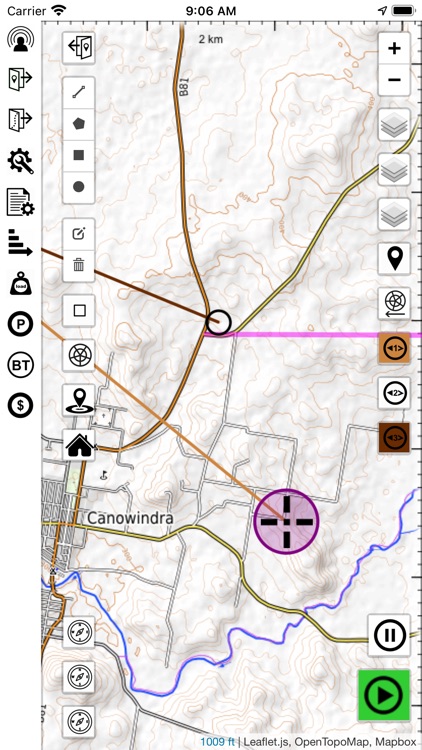
Balloon Nav is a full featured GPS mapping and live track sharing app that has all the tools you need to get the most out of your flying

Balloon Nav
by Anthony Kerr
What is it about?
Balloon Nav is a full featured GPS mapping and live track sharing app that has all the tools you need to get the most out of your flying. The live track sharing feature allows you to share your flight and receive the flight data from up to 8 others. The app has the full capabilities for loading kml overlays and waypoints, online/offline maps, drawing over the map, setting navigation lines, dropping markers and clicking the track line to get the GPS data. There is a robust database backend that stores the settings and track files for later (great for logbooks). There is a pinball reader function that allows sharing readings with your tracking group and a met wind data plotter. In addition there is a load calculator, and as an extra purchase an addon bluetooth barometric altitude module available.
App Store Description
Balloon Nav is a full featured GPS mapping and live track sharing app that has all the tools you need to get the most out of your flying. The live track sharing feature allows you to share your flight and receive the flight data from up to 8 others. The app has the full capabilities for loading kml overlays and waypoints, online/offline maps, drawing over the map, setting navigation lines, dropping markers and clicking the track line to get the GPS data. There is a robust database backend that stores the settings and track files for later (great for logbooks). There is a pinball reader function that allows sharing readings with your tracking group and a met wind data plotter. In addition there is a load calculator, and as an extra purchase an addon bluetooth barometric altitude module available.
Please be advised that the majority of this app will not be accessible without an in-app purchase of a monthly subscription.
We provide a video user manual at the following youtube channel.
https://www.youtube.com/channel/UCHaHYG7fI3i_gDTIO9Kegsw
This is a link to an example of a map definition file .. please watch the maps tutorial on youtube. Example of the USGS Topo map
https://drive.google.com/file/d/1VaJqXiUeDZNB9IJJx_YGZrtFIVD4zzlW/view?usp=sharing
The GPS system is quite poor for altitude calculation, so Balloon Nav has developed an add on Bluetooth Altitude Module that uses barometric altitude. The module connects seamlessly, has fine QNH control from the app and is very accurate. It will be available for purchase through eBay soon, search Balloon Nav Altitude Module on eBay.com.au.
Terms of Use
https://www.websitepolicies.com/policies/view/dZd5rrmd
Privacy Policy
https://www.websitepolicies.com/policies/view/eiZVGlyM
Disclaimer
https://www.websitepolicies.com/policies/view/VotkZOJO
Disclaimer:
AppAdvice does not own this application and only provides images and links contained in the iTunes Search API, to help our users find the best apps to download. If you are the developer of this app and would like your information removed, please send a request to takedown@appadvice.com and your information will be removed.
AppAdvice does not own this application and only provides images and links contained in the iTunes Search API, to help our users find the best apps to download. If you are the developer of this app and would like your information removed, please send a request to takedown@appadvice.com and your information will be removed.