You are using an outdated browser. Please
upgrade your browser to improve your experience.

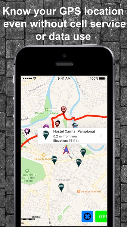
Know exactly where you are on the Camino Frances without needing cellular service and without using any of your data plan

Camino de Santiago Companion
by Guthook Hikes, LLC
What is it about?
Know exactly where you are on the Camino Frances without needing cellular service and without using any of your data plan! Camino Companion shows your GPS location right on the map along with 500 accommodation listings and 800 other waypoints from Saint-Jean-Pied-de-Port to Muxia, including junctions, road crossings, churches, and towns. Each waypoint includes further detail on a dedicated page.
Camino de Santiago Companion is FREE but there are more add-ons
-
$7.99
Camino Frances
-
$4.99
Camino Short Version
App Screenshots
App Store Description
Know exactly where you are on the Camino Frances without needing cellular service and without using any of your data plan! Camino Companion shows your GPS location right on the map along with 500 accommodation listings and 800 other waypoints from Saint-Jean-Pied-de-Port to Muxia, including junctions, road crossings, churches, and towns. Each waypoint includes further detail on a dedicated page.
NO WIFI OR CELLULAR SERVICE NEEDED FOR GPS
Know your exact GPS location and how far you are from your next stop, exactly where to go for accommodations and important sites, and whether you took the correct turn, all without needing a cellular signal or using any of your data plan. After the initial setup, Camino Companion uses a combination of your smartphone's GPS, downloaded topo maps, and the Apple Maps interface to accurately locate your position on the Camino.
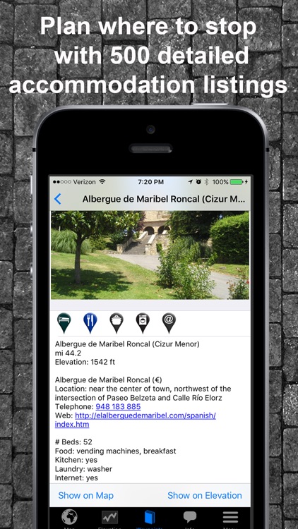
500 ACCOMMODATION LISTINGS (ALBERGUES, HOSTELS, HOTELS)
Check out 500 accommodation options right from the map view or browse a dedicated accommodation list, showing each option and distance from your current GPS location. Each one has a dedicated page with further information including kitchen, laundry, internet, and meal details.
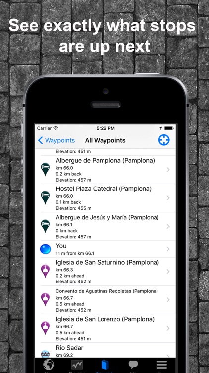
OVER 800 OTHER WAYPOINTS
Know what’s up ahead on the trail with over 800 other waypoints including churches, chapels and cathedrals, water sources, scenic views, road junctions and crossings, bridges, and turns. Plan your day knowing what’s next and never miss an important site.
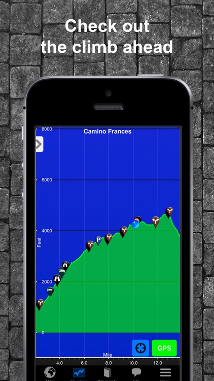
SEE CURRENT ELEVATION AND CHANGE AHEAD
See the terrain ahead by viewing your current location and all waypoints on an elevation profile. Each waypoint is clickable, opening to the waypoint's detail page.
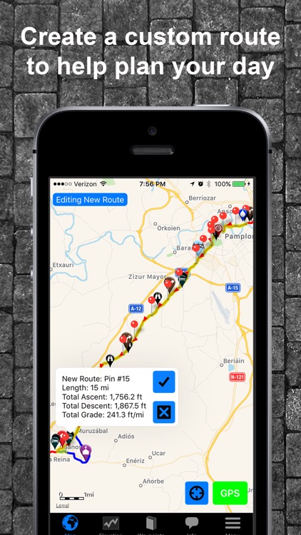
ROUTE PLANNER
Create a route plan for the day and see the total distance and elevation change to help you decide where to stay for the night.
JUNCTION DETAIL
Check instructions for key junctions to always know where to go.
POINT OF INTEREST DETAIL
Views images of key waypoints to help plan where to stop.
TRY IT OUT BEFORE YOU PURCHASE
The free demo covers the 42-mile (68-km) segment from Saint-Jean-Pied-de-Port to Pamplona. The demo is fully functional with all of the features of the paid version. In-app purchases include (1) the 557-mile/896-km Camino Frances from Saint-Jean-Pied-de-Port to Muxia (via Santiago de Compostela) and (2) an abbreviated 71-mile/114-km Camino Frances from Sarria to Santiago de Compostela.
SHARE YOUR LOCATION
Send your current location to friends and family via text message, e-mail, facebook, or twitter.
WAYPOINTS INCLUDE
--> Accommodation (albergues, hostels, hotels), including kitchen, laundry, internet and meal information
--> Towns
--> Water taps and fountains
--> Churches, cathedrals, chapels
--> Junctions
--> Road Crossings
--> Scenic Views
--> River and stream crossings
--> Other points of interest (sculptures, historic waypoints, etc.)
This app is a collaboration between long-distance hiker Keith Foskett and the creators of the popular Guthook's Guides series of long distance hiking apps.
Note: Continued use of GPS running in the background can dramatically decrease battery life.
Disclaimer:
AppAdvice does not own this application and only provides images and links contained in the iTunes Search API, to help our users find the best apps to download. If you are the developer of this app and would like your information removed, please send a request to takedown@appadvice.com and your information will be removed.
AppAdvice does not own this application and only provides images and links contained in the iTunes Search API, to help our users find the best apps to download. If you are the developer of this app and would like your information removed, please send a request to takedown@appadvice.com and your information will be removed.