You are using an outdated browser. Please
upgrade your browser to improve your experience.

Cessna iFlite is an iPad application and requires a $139

Cessna iFlite
by Hilton Software LLC
What is it about?
Cessna iFlite is an iPad application and requires a $139.95 annual subscription for full functionality. The initial purchase of 99c enables you to view A/FD and AOPA Directory information, to purchase and view Cessna POHs, and to have full access to the E6B. Viewing your aircraft's location on an approach chart requires a ChartData subscription with Seattle Avionics (not required to view charts or for SmartTaxi).
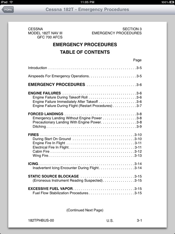
App Screenshots
App Store Description
Cessna iFlite is an iPad application and requires a $139.95 annual subscription for full functionality. The initial purchase of 99c enables you to view A/FD and AOPA Directory information, to purchase and view Cessna POHs, and to have full access to the E6B. Viewing your aircraft's location on an approach chart requires a ChartData subscription with Seattle Avionics (not required to view charts or for SmartTaxi).
*** Now with ADS-B InFlight Moving Map Weather ***
Cessna iFlite feature set includes Weight and Balance, Takeoff and Landing Performance, and Aircraft POHs (additional purchase) for in-production single-engine Cessna aircraft including the Skycatcher, Skyhawk, Skylane, StationAir, Caravan, and Corvalis:
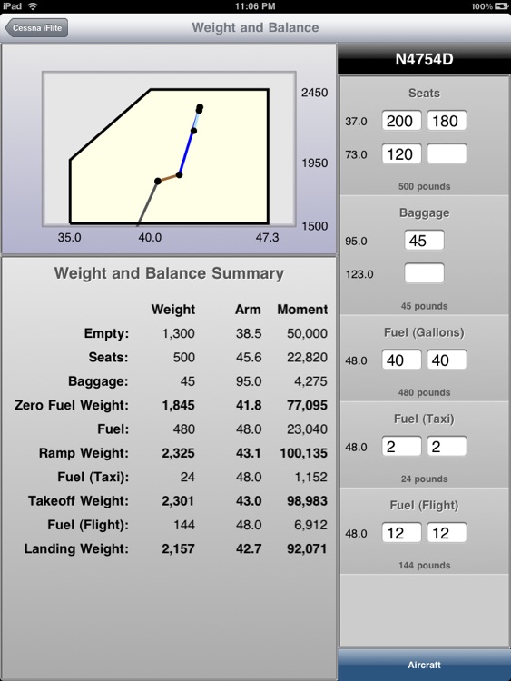
● Weight and Balance
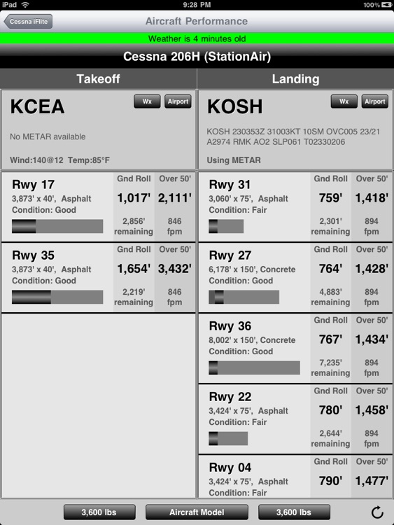
● Takeoff and Landing Performance
● Aircraft POHs
GPS Information
● Compatible with internal GPS receiver, Bad Elf, Bluetooth GNS 5870 (or other Apple-approved GPS receiver), and the SkyRadar's ADS-B Receiver.
Cessna iFlite's tremendous feature set includes:
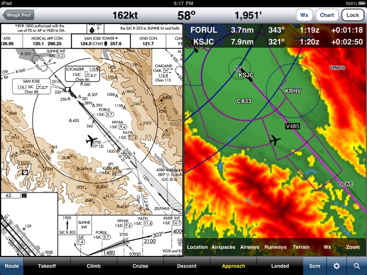
Multi-View GPS-Enabled Moving Map
● VFR Sectionals and IFR low/high enroute charts
● Overlay terrain onto enroute charts - see what is above you
● ADS-B InFlight Weather - NEXRAD, METARs, TAFs, AIRMETs, PIREPs, NOTAM-Ds.
● Displays Class B, C, and D Airspaces and Special Use Airspaces
● Airspaces Notifications
● SUAs and TFRs on the Moving Map -simply tap to get info.
● Adjust the Moving Map brightness easily
● Route CDI
● Direct-To option
● Impressive pinch-to-zoom
● Knots, MPH, km/h
A/FD, AOPA Directory, and Maps
● Comprehensive A/FD includes Airport, NavAids, and Fixes information.
● AOPA Directory includes FBOs, Attractions, Car Rentals, Hotels/Motels, Restaurants, Taxi Services, and Airport Diagrams.
● Includes Bahamas and Puerto Rico
● Integrated Maps and Yelp
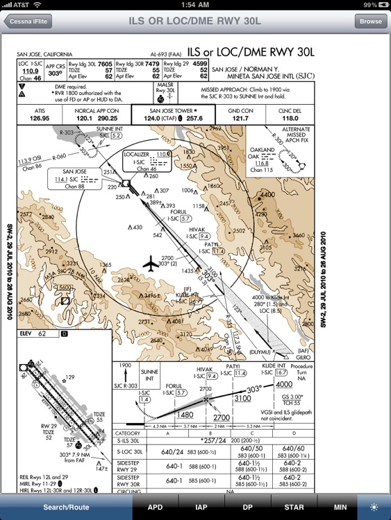
Approach Charts
● SmartTaxi™
● The entire USA is stored on your iPad
● Easy to filter on All, ILS Only, GPS Only, or Six-Pack
● All charts are zoomable
● Print charts wirelessly
● Rotate DPs and STARs.
Wx Text
● Color-coded METARs, TAFs, winds/temperatures aloft
● Shows nearby airports with distance and direction
● Includes Alaska and Hawaii
● Celsius/Fahrenheit selectable
● Show/Hide RMK section
● Calculates METAR Density Altitude
● Calculates freezing level
Wx Images
● NOAA weather images include Animated RADAR, Satellite, Icing, Wind, Flight Conditions, Weather Forecast, Prog Charts, Lightning, and more
● Includes Alaska and Hawaii
Route Planning
● Enter identifiers including Victor Airways and Jetways
● Easily modify route by dragging to reorder
● Waypoints are automatically inserted in correct position
● Show Total and Longer Than Direct distances
● Flight Log shows Magnetic Headings, Groundspeed, ETE, Fuel Burn by using winds aloft information
● Optimize Altitude for winds aloft
DUATS
● Flight Plans and Weather Briefings downloaded using secure connection (optional) and are official and recorded by DUATS.com and can be reused for fast filing
● File, Close, and Cancel flight plans
● Obtain Weather Briefings - Route and Area
● Aircraft Manager auto-fills Tail, Type/Equipment, TAS, and Color fields of flight plan
● Part 135 friendly
TFRs
● Displayed on Moving Map
● Popup shows textual information
● Show Active or Pending TFRs (active within 24 hours)
E6B
● Conversions
● Distance-Speed-Time
● Pressure/Density Altitude
● Winds Aloft
● Runway Winds
● IFR Climb
● Descent Rate
Airport Status
● Show Airport Status at major airports
Documents
● FARs including Parts 1, 43, 61, 91, 119, 121, 135, 137, 141, NTSB 830, 1552, and 1562
● Parts of the AIM
● AC61-65E - Including Endorsements
● AC61-67C - Stall and Spin Awareness Training
● Pilot/Controller Glossary
● Aeronautical Contractions
● FSS Phone Numbers
Integrated Help System
● Built-in mini-manual
Note: Continued use of GPS running in the background can dramatically decrease battery life.
Disclaimer:
AppAdvice does not own this application and only provides images and links contained in the iTunes Search API, to help our users find the best apps to download. If you are the developer of this app and would like your information removed, please send a request to takedown@appadvice.com and your information will be removed.
AppAdvice does not own this application and only provides images and links contained in the iTunes Search API, to help our users find the best apps to download. If you are the developer of this app and would like your information removed, please send a request to takedown@appadvice.com and your information will be removed.