You are using an outdated browser. Please
upgrade your browser to improve your experience.

Fires gives you the best wildfire information, accurate air quality and wind, global weather conditions, and a growing atlas of offline maps, everything you and your family need to stay aware and on track during the wildfire season and throughout the year

Fires: Wildfire News and Atlas
by Ryan Strouse


What is it about?
Fires gives you the best wildfire information, accurate air quality and wind, global weather conditions, and a growing atlas of offline maps, everything you and your family need to stay aware and on track during the wildfire season and throughout the year.
App Screenshots


App Store Description
Fires gives you the best wildfire information, accurate air quality and wind, global weather conditions, and a growing atlas of offline maps, everything you and your family need to stay aware and on track during the wildfire season and throughout the year.
▶▶ WILDFIRE INFO
▶ Nearest Wildfires and Nearest Fires
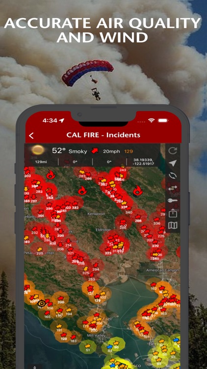
Fires has a consolidated feed of the nearest wildfires from all the agencies that the app supports, and a feed of the nearest fires (hotspots) that NASA satellites have detected. The feeds are located at the top of the Home screen to provide you with quick access to the wildfire information that you need including: address, zip code, county, neighborhood, acres burned, and the percent contained; the details can be viewed at a glance.
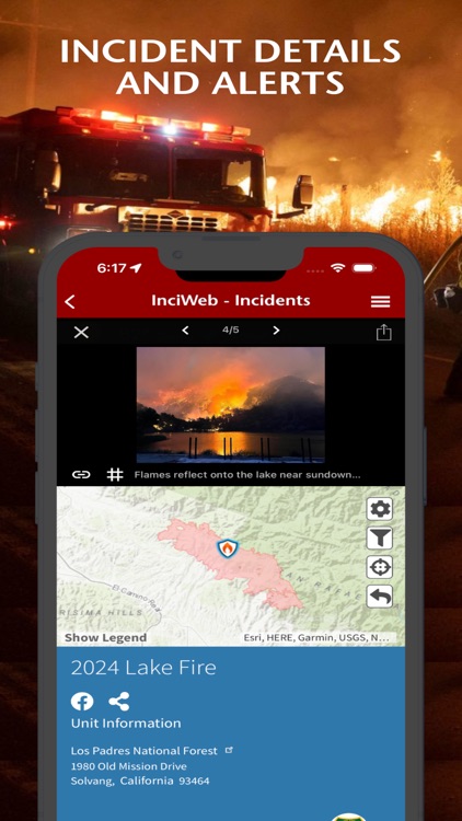
▶ Incident Details
Fires provides maps, photos, perimeters, and information about wildfires from the following sources for the United States:
• InciWeb
• CAL FIRE
• NIFC
See evacuation updates, view air tanker locations, share wildfire information and high resolution photos, .
▶ Alerts with Containment Updates
Fires will notify you when new incidents are downloaded within the maximum distance that you set from the source that you select including InciWeb and CAL FIRE.
▶ Thermal Hotspots and Fire Activity
Fires lets you to interactively browse the full set of global active fire detections from MODIS and VIIRS:
• Collection-6 MODIS Active Fire Data
• VIIRS I-Band 375m Active Fire Data
▶ Satellite Images and Animations
Fires provides extensive near real-time GOES (Geostationary Operational Environmental Satellite) imagery from NOAA.
▶ Global Weather Conditions including Wind and Air Quality (where available).
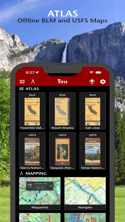
▶▶ ATLAS
▶ Offline 3D Basemaps, BLM maps, and USFS maps
• Several Basemaps
• 20 BLM Reference Maps for California, and we are currently adding many more to this collection.
• 21 USFS National Forest Maps for California, and we are currently adding many more to this collection.
▶ Mapping Tools with offline GPS functionality
▶▶ SUBSCRIPTIONS
Subscriptions automatically renew unless auto-renew is turned off at least 24 hours before the end of the current period. Your iTunes account will be charged for renewal within 24 hours of the end of the current period, and identify the cost of the renewal.
▶ FIRES PRO ELITE ($29.99/year)
Yearly access to the entire Fires Atlas, this includes unlimited access to all the Basemaps, BLM reference maps, and USFS reference maps.
• Access Incident Weather Conditions.
• Access Nearby Weather Conditions.
• Unlimited Global Weather Conditions using Waypoints.
• Remove Ads.
▶ FIRES PRO ($14.99/year)
Yearly access to all the Basemaps along with yearly access to 4 BLM and USFS reference maps. Each reference map selection will last for 3 months at a time. After 3 months each reference map selection expires, then you can change that selection to any other reference map in the Fires Atlas.
• Access Incident Weather Conditions.
• Remove Ads.
• 7 day free trial.
▶ TO MANAGE YOUR SUBSCRIPTION:
• TURN OFF auto-renewal via the main Settings app: http://support.apple.com/kb/ht4098
• Subscriptions automatically renew unless auto-renew is turned off at least 24 hours before the end of the current period. Your iTunes account will be charged for renewal within 24 hours of the end of the current period, and identify the cost of the renewal.
• Your iTunes Account will be charged at confirmation of purchase.
• Visit the following URL to view our Privacy Policy: http://www.livewaremedia.com/p/privacy-policy.html
• Visit the following URL for full terms of use: http://www.livewaremedia.com/p/terms-and-conditions.html
Disclaimer:
AppAdvice does not own this application and only provides images and links contained in the iTunes Search API, to help our users find the best apps to download. If you are the developer of this app and would like your information removed, please send a request to takedown@appadvice.com and your information will be removed.
AppAdvice does not own this application and only provides images and links contained in the iTunes Search API, to help our users find the best apps to download. If you are the developer of this app and would like your information removed, please send a request to takedown@appadvice.com and your information will be removed.