You are using an outdated browser. Please
upgrade your browser to improve your experience.

Measuring is easy

GPS Land Measurement & Survey
by LogiSian Technology Solutions


What is it about?
Measuring is easy! With just a few taps, calculate area, distance, and perimeter for roofs, land, farms, or any property. Whether you're surveying or marking boundaries, get accurate results instantly. Perfect for professionals and casual users alike, it simplifies all your measurement needs.
GPS Land Measurement & Survey is FREE but there are more add-ons
-
$6.99
Upgrade to Pro
App Screenshots


App Store Description
Measuring is easy! With just a few taps, calculate area, distance, and perimeter for roofs, land, farms, or any property. Whether you're surveying or marking boundaries, get accurate results instantly. Perfect for professionals and casual users alike, it simplifies all your measurement needs.
# Features:
• 5 different measurement tools.
• Supports Area, Distance, and Radius on the map.
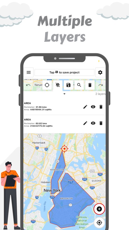
• Allows multiple layers within a project.
• For measurement, it has 9 different metric units for area and 6 for distance.
• Customizable line width, line color, and fill color.
• Multiple map types available.
• GPS Live for calculating as you walk.
• Location search functionality.
• Undo/Redo feature.
• Export and share project measurements easily.
• Supports KML and GeoJson files.
# Useful for:
• Farmers & Agronomists: Measuring farmland areas.
• Real Estate Agents: Marking property boundaries.
• Construction Engineers: Measuring construction sites.
• Roofing Contractors: Measuring roof sizes.
• Hikers & Trekkers: Planning hiking routes.
• Surveyors: Land and landscape surveys.
• Sports Enthusiasts: Measuring track distances.
• Civil Engineers: Road and structure measurements.
If you have any feedback or ideas to help us build the Mapulator application, please contact us via email. Your support will help us improve the application.
Disclaimer:
AppAdvice does not own this application and only provides images and links contained in the iTunes Search API, to help our users find the best apps to download. If you are the developer of this app and would like your information removed, please send a request to takedown@appadvice.com and your information will be removed.
AppAdvice does not own this application and only provides images and links contained in the iTunes Search API, to help our users find the best apps to download. If you are the developer of this app and would like your information removed, please send a request to takedown@appadvice.com and your information will be removed.