You are using an outdated browser. Please
upgrade your browser to improve your experience.
GPS Marine Charts App offers access to charts covering Brazil waters (derived from CENTRO DE HIDROGRAFIA DA MARINHA data)

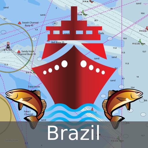
i-Boating : Brazil Marine Navigation Maps & Charts
by Bist LLC
What is it about?
GPS Marine Charts App offers access to charts covering Brazil waters (derived from CENTRO DE HIDROGRAFIA DA MARINHA data).
App Screenshots
App Store Description
GPS Marine Charts App offers access to charts covering Brazil waters (derived from CENTRO DE HIDROGRAFIA DA MARINHA data).
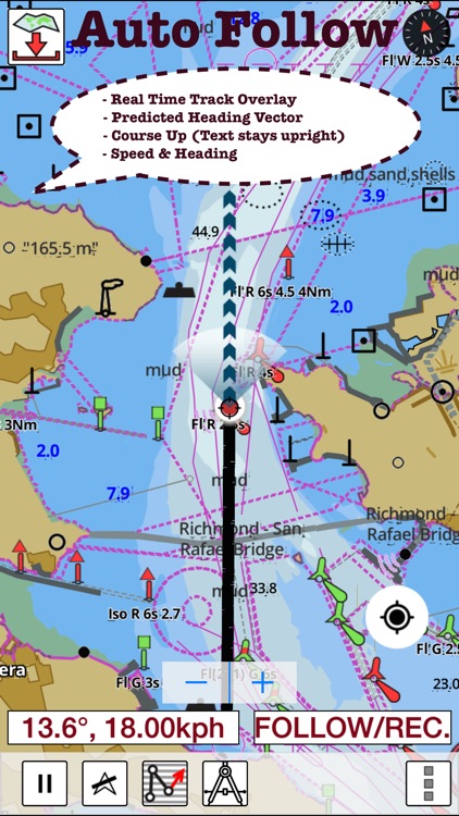
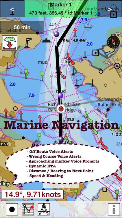
Only marine GPS app to have route assistance with Voice Prompts for marine navigation. It has route manager to create new boating routes or import existing GPX/KML routes. It supports Nautical Charts course up orientation.
Please visit
http://gpsnauticalcharts.com/main/brazil/all-all-brazil-charts-nautical-charts-folio.html
for complete list. If you don't find the chart for Brazil , please contact us at support at gpsnauticalcharts.com.
* Voice Prompts for marine navigation (requires GPS )
-prompts when approaching a boating route marker
-Continous distance and ETA updates
-Alerts when sailing/boating off route
-Alerts when boating in wrong direction
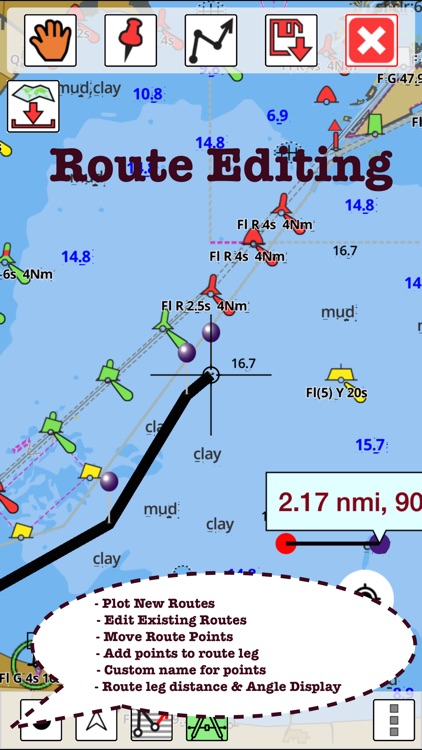
*Route Editing/Creation
-Create routes from scratch
-Edit existing GPX/KML routes.
-Add custom description to any route point.
-Drop markers along route.
* Offline charts derived from IHM data.
-Visually draw area to download
-Textual search
-Catalog
-Charts reprojected for WGS84 datum
*Seamless chart quilting of marine charts
*Distance Bearing tool
*Create custom way points
- Using GPS
-Select point on map
-Manually enter latitude & longitude coordinates
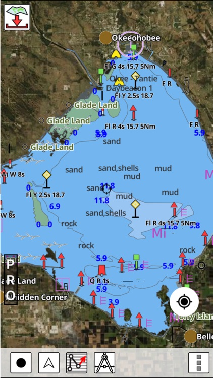
*POI layer for marine charts
- Overlay POIs
- POI list derived from the equivalent ENC and contains all categories including Buoy, Light, Harbour facility, Obstr.
*Search POIs/Way points
*Pan/Zoom/My Location
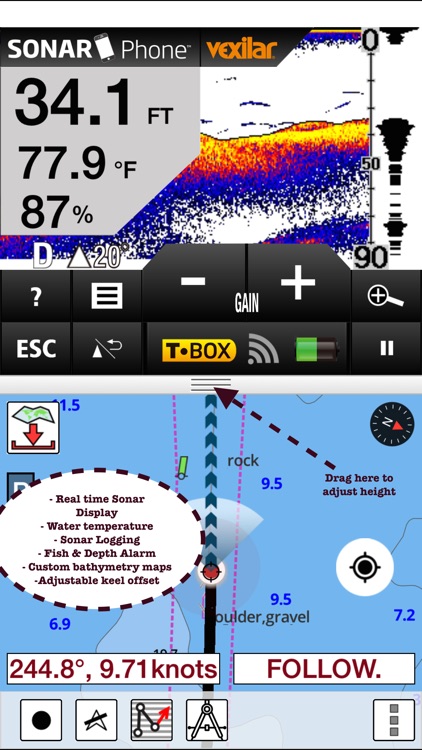
* Record Marine GPS tracks
* View tracks overlay
* Live track animation
* Track analytics/stats
* Export GPX tracks.
-Export to SDCard
-Share GPX trakcs with friends.
* Auto Follow Mode (Course up)
-Continuously updates boat's location on chart
- Adjustable update frequency
Sample Nautical Charts
ARQUIPELAGO DE SAO PEDRO E SAO PAULO
ATOL DAS ROCAS
BAIA DA ILHA GRANDE PARTE CENTRAL
BAIA DE GUANABARA
TODOS OS SANTOS PARTE NORTE
BAIAS CABRALIA E DE PORTO SEGURO
BARRA DO RIO DE JANEIRO
BARRA DO RIO GUAIBA
CANAL SANTANA
CANAL SAO ROQUE
CANAL DOS ABROLHOS
CANAL NORTE SANTA CATARINA
CANAL SUL SANTA CATARINA
COSTA SUESTE DA AMERICA DO SUL
CURRALINHO
SUCURI AO PASSO OLIMPO
CASTELO AO JATOBAZINHO
CURURU A ILHA DO CASTELO
PAPAGAIO AO PASSO DO MORRO PELADO
TUIUIU A CANCHA DO PIUVAL
CONCEICAO DA BARRA A VITORIA
FOZ DO RIO NEGRO A ILHA PATATIVA
COUVES A ILHA DO MAR VIRADO
BAILIQUE A PONTA DO CAPINAL
RABO EMA À ILHA DO ALGODOAL
ILHA SEPUTA A FOZ DO RIO NEGRO
VERDE AO PASSO PARAGUAI MIRIM
DEL LOCO AO PASO SIETE PUNTAS
ESPERANZA A ISLA YSYPO-I
PEDERNAL AO PASO CAA-PUCU-MI
PITO-CAÑY A ISLA OCULTO
POYBIA A ISLA URUGUAYTA
SAN ALFREDO A ISLA SAN JUAN
UBU AO CABO SAO TOME
GROSSA A PORTO ALEGRE
MACEIO AO CABO CALCANHAR
PONTA TUCUMA A PONTA DO GUARA
SARACURA AO ESTIRÃO DOMINGOS RAMOS
SUCURI AO PASSO COQUEIRO
ACURIZAL AO RIACHO DO ABRIGO
CARANDAZINHO A VOLTA DO CURURU
JAU AO ESTIRÃO DA CAPIVARA
SINIMBU AO PASSO PIUVA
GRANDE A ILHA ESTREITA OU PIMENTEIRA
MORCEGUEIRO AO PASSO DA FAIA
BELA VISTA DO NORTE AO ESTIR
CAYENNE AO CABO GURUPI
CORUMBA AO ESTIRAO DA AGUA BRANCA
IMBITUBA A PINHAL
ITAPUA A PONTA DO ARADO VELHO
SANTOS A ARROIO CHUI
VITORIA AO CABO SAO TOME
SIETE PUNTAS AO PASO MILAGRO
REBOJO GRANDE A ILHA DO MARCO
DO RECIFE A BELMONTE
ENSEADA BUZIOS
ENSEADA MACAE
ENSEADA UBATUBA
ENSEADAS DO CABO FRIO
FOZ DO RIO APA
FUNDEADOURO SAO MIGUEL
ILHA GAMELA E FOZ DO RIO BRACINHO
LAGOA GA
LAGO BRASILIA
BRASILIA - PARTE CENTRAL
CABEDELO
CAMAMU
CANANÉIA
CARAVELAS
IMBITUBA
LAGUNA
LUIS CORREIA
MACAU
MACEIO
MADRE DE DEUS
NATAL
SANTANA
SANTOS
SANTOS - CANAL ACESSO
PORTO SAO ROQUE
PORTO DO RIO JANEIRO
PORTO LUIS CORREIA
BARRA SUL DO RIO AMAZONAS
ILHA SANTA CATARINA
PONTA DO UBU
ATOL DAS ROCAS
PORTO MACEIO
PUERTO VALLEMI
RIO PARAGUAI
PLEASE NOTE: Continued use of GPS running in the background can dramatically decrease battery life.
Disclaimer:
AppAdvice does not own this application and only provides images and links contained in the iTunes Search API, to help our users find the best apps to download. If you are the developer of this app and would like your information removed, please send a request to takedown@appadvice.com and your information will be removed.
AppAdvice does not own this application and only provides images and links contained in the iTunes Search API, to help our users find the best apps to download. If you are the developer of this app and would like your information removed, please send a request to takedown@appadvice.com and your information will be removed.