You are using an outdated browser. Please
upgrade your browser to improve your experience.
Discover the INATrace App

INATrace
by Sunesis


What is it about?
Discover the INATrace App
App Screenshots


App Store Description
Discover the INATrace App
INATrace is a digital open-source solution designed to enhance the economic conditions of smallholder farmers by improving the traceability of global supply chains. Funded by the German Federal Ministry for Economic Cooperation and Development (BMZ) and implemented by GIZ, INATrace focuses on providing an efficient internal management system for cooperatives, digitally storing supply chain data, and supporting compliance with new regulations like the EU Deforestation Regulation (EUDR). INATrace helps cooperatives transition to fully transparent and digital processes, empowering them with complete ownership of their data and strengthening their negotiating position with buyers.
Key Functionalities
Polygon Mapping & Creation of Farmer Profiles: The INATrace App allows users to create new farmer profiles effortlessly, ensuring that all data on the cooperative’s farmers is recorded accurately. Additionally, the app provides robust polygon mapping features, enabling users to record GPS data and delineate field boundaries. To do so unique geoIDs are created based on the codes of the Asset Registry provided by Linux foundation enabling a smooth data exchange.
Deforestation risk assessment: In the desktop version, the collected polygons are displayed on a map and integrated with FAO's WHISP (What is in that plot) tool. This allows for an initial deforestation risk assessment, providing valuable insights and supporting compliance with environmental regulations.
Offline Functionality and Synchronization
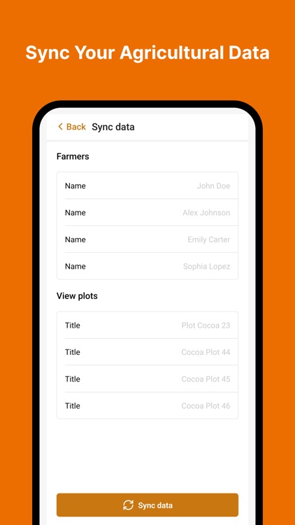
Offline Usage: The INATrace App is designed for use in remote areas with limited internet access and provides offline maps. Users can record and store data offline, including farmer profiles, and GPS and polygon data. This ensures that all necessary information is captured in real-time, regardless of internet connectivity.
Synchronization: Once an internet connection is available, the app automatically syncs all recorded data with the desktop version. This seamless synchronization ensures that cooperatives have access to the most up-to-date information, fostering transparency and efficiency within the supply chain.
Join INATrace and Build the global agricultural supply chain
Download the INATrace mobile app today and step into the future of farm data management. Combined with the desktop application, you can access advanced features such as traceability and deforestation risk monitoring for the entire supply chain. Join us in creating a more transparent and equitable global supply chain.
Additionally, you can access the INATrace app as a guest to map your plots, manage your farmers, and maps offline. Under this mode, your data will be stored locally on your device.
Disclaimer:
AppAdvice does not own this application and only provides images and links contained in the iTunes Search API, to help our users find the best apps to download. If you are the developer of this app and would like your information removed, please send a request to takedown@appadvice.com and your information will be removed.
AppAdvice does not own this application and only provides images and links contained in the iTunes Search API, to help our users find the best apps to download. If you are the developer of this app and would like your information removed, please send a request to takedown@appadvice.com and your information will be removed.