You are using an outdated browser. Please
upgrade your browser to improve your experience.

Revolutionizing Industrial Inspections: Image On Map Panorama Capturing Inspection

IOM Image on Map
by Capnor AS

What is it about?
Revolutionizing Industrial Inspections: Image On Map Panorama Capturing Inspection
App Screenshots
App Store Description
Revolutionizing Industrial Inspections: Image On Map Panorama Capturing Inspection
Tool redefines precision and efficiency. This tool fuses technology, design, and
collaboration, reshaping how professionals approach inspections.
Explore its captivating features:
I. The Power Duo: Tablet Application and High-Resolution Spherical Camera
At its core, Image On Map combines a tablet application with a high-resolution
spherical camera, transforming the inspection experience. This duo provides the
flexibility of a mobile interface and the image precision of a top-tier spherical camera,
empowering inspectors for comprehensive and accurate inspections.
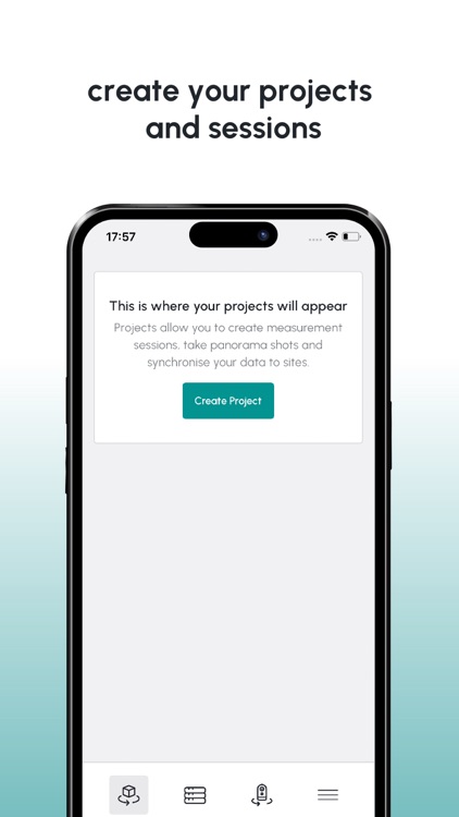
II. Streamlined Preparation: Download Calibrated Plot Plans from Ayelix
Image On Map seamlessly integrates with Ayelix, allowing users to download
calibrated plot plans directly. This eliminates tedious data preparation, expediting the
process and ensuring inspectors have accurate and up-to-date information, setting
the stage for meticulous inspections.
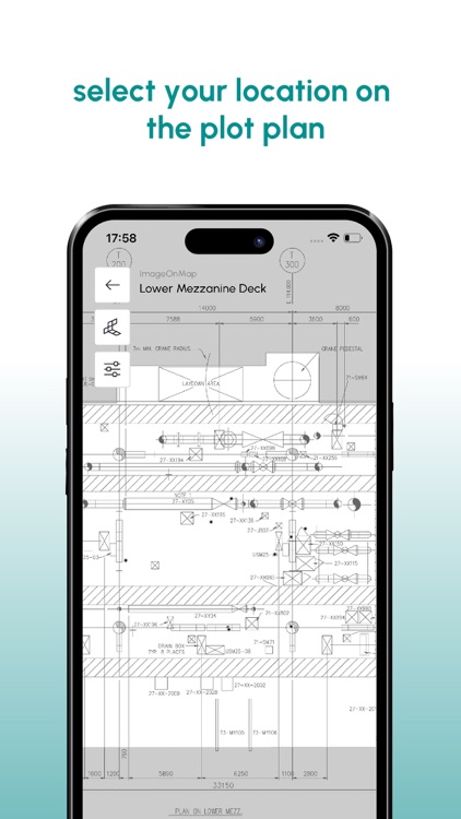
III. Visual Precision: Marking Camera Position on Plot Plans
A revolutionary feature allows users to mark the exact camera position on
downloaded plot plans, enhancing spatial awareness during on-site activities. This
digital precision combined with on-the-ground reality addresses the unique needs of
industrial inspections.
IV. Capturing Essence: High-Resolution Spherical Photography
The high-resolution spherical camera captures industrial sites with breathtaking
detail, prioritizing image quality for comprehensive visual records. Image On Map
ensures no aspect, from minute details to panoramic vistas, goes unnoticed.
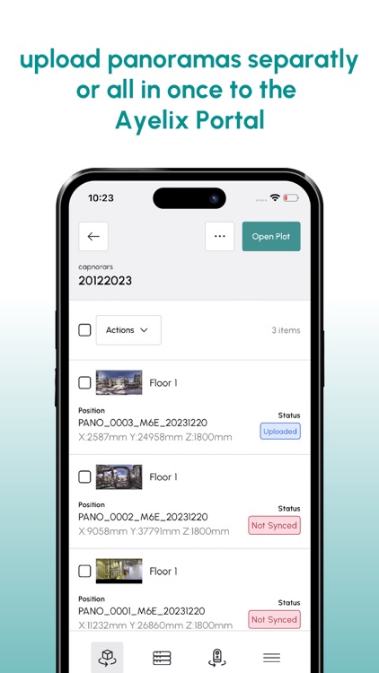
V. Real-Time Harmony: Automatic Data Sync with Ayelix Servers
Image On Map keeps pace with industrial inspections through automatic data
synchronization with Ayelix servers. This real-time harmony enhances collaboration,
accelerates decision-making, and fortifies the reliability of the inspection process.
VI. Collaboration Unleashed: Share Data in Minutes
In the realm of industrial inspections, collaboration is key. Image On Map facilitates
solo operations and excels in promoting teamwork. Users can share captured data
with colleagues and stakeholders in minutes, fostering a collaborative ecosystem.
VII. Accessibility Redefined: Anywhere, Anytime Inspection
Image On Map liberates inspectors from traditional constraints, enabling work from
anywhere with an internet connection. Remote inspections, data analysis, and
seamless collaboration redefine the inspection workflow, turning mobile devices and
tablets into portals to the industrial site.
VIII. Future-Ready Innovation: Image On Map and Ayelix
As technology evolves, so does Image On Map. Seamless integration with Ayelix
ensures users participate in a continuous journey of innovation. Updates,
enhancements, and new features are seamlessly delivered, keeping Image On Map at
the forefront of technological advancement in industrial inspections.
IX. Conclusion: Transforming Inspections, Redefining Efficiency
In the competitive landscape of industrial inspections, Image On Map Panorama
Capturing Inspection Tool emerges as a transformative force. Its blend of technology,
design, and commitment to precision positions it as an indispensable asset for
professionals. From the initial download of plot plans to seamless data sharing,
Image On Map transcends boundaries, heralding a new era of efficiency and
collaboration. Welcome to the future of industrial site inspections – welcome to Image
On Map.
Disclaimer:
AppAdvice does not own this application and only provides images and links contained in the iTunes Search API, to help our users find the best apps to download. If you are the developer of this app and would like your information removed, please send a request to takedown@appadvice.com and your information will be removed.
AppAdvice does not own this application and only provides images and links contained in the iTunes Search API, to help our users find the best apps to download. If you are the developer of this app and would like your information removed, please send a request to takedown@appadvice.com and your information will be removed.