You are using an outdated browser. Please
upgrade your browser to improve your experience.
The ITS Geo app is an augmented reality application that enables the user to accurately survey and visualize infrastructure asset data and subsurface utilities

ITS Geo
by ITS Geo Solutions GmbH


What is it about?
The ITS Geo app is an augmented reality application that enables the user to accurately survey and visualize infrastructure asset data and subsurface utilities. It is specifically designed to survey house connection and similar projects. It has been developed for field service personnel, fitters, contractors and construction companies. Collected data is overlaid over the video stream for visual quality assurance.
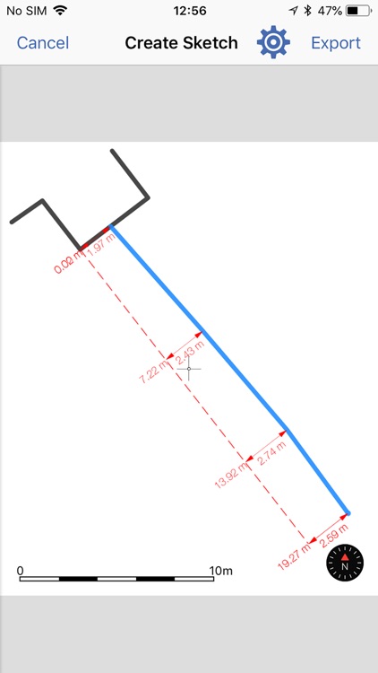
App Screenshots


App Store Description
The ITS Geo app is an augmented reality application that enables the user to accurately survey and visualize infrastructure asset data and subsurface utilities. It is specifically designed to survey house connection and similar projects. It has been developed for field service personnel, fitters, contractors and construction companies. Collected data is overlaid over the video stream for visual quality assurance.
ITS Geo uses GNSS and Visual Inertial Odometry (VIO) to accurately track the world around it.
Features
• Data collection and measurements in Augmented Reality View
• Quality and status information
• Feature Manager and Layer controls
• Point, linear and polygon feature support
• Sync data between multiple devices
• Photo documentation of results
• Export as Esri SHP, Geo-referenced images and PDF field sketch
ITS Geo requires iOS 11.3 and devices with A9, A10, A11 Bionic processors or higher: iPhone SE, iPhone 6s, iPhone 6s Plus, iPhone 7, iPhone 7 Plus, iPhone 8, iPhone 8 Plus, iPhone X, iPad (2017 and 2018) and iPad Pro.
Subscription types:
1. Free Subscription functionality:
• Up to 150 projects
• Data collection and measurements in Augmented Reality View
• Collected data can't be saved or exported
• Feature Manager and Layer controls
• Free 14 days trial of all “Professional" subscription features
2. Professional Subscription (US$29.99 per month). All the features of the “Free" subscription, plus:
• Unlimited number of projects
• Data collection and measurements in Augmented Reality View
• Quality and status information
• Feature Manager and Layer controls
• Point, linear and polygon feature support
• Sync data between multiple devices
• 1 GB cloud storage for your projects
• Photo documentation of results
• Export as Esri SHP, geo-referenced images and PDF field sketch
Purchase of a ITS Geo subscription allows you to run the ITS Geo App on all supported platforms, with your projects being automatically synchronized between your devices. Subscription payments will be charged to your iTunes Account at confirmation of purchase and will automatically renew unless you cancel your subscription or turn off auto-renewal at least 24-hours prior to the end of the current subscription period. A cancelled subscription remains active until the end of the current period, at which time your account reverts to the “Free" subscription functionality.
Customers selecting the Free Trial will enjoy “Professional" subscription features for a period of 14 days, after which they can elect to purchase a “Professional" subscription. In the absence of a purchase, their account will revert to “Free" subscription functionality.
For further information:
• ITS Geo Privacy Policy:
https://its-geo.de/richtlinien/datenschutzerklaerung.php
• ITS Geo Terms and Conditions:
https://its-geo.de/richtlinien/impressum.php
Disclaimer:
AppAdvice does not own this application and only provides images and links contained in the iTunes Search API, to help our users find the best apps to download. If you are the developer of this app and would like your information removed, please send a request to takedown@appadvice.com and your information will be removed.
AppAdvice does not own this application and only provides images and links contained in the iTunes Search API, to help our users find the best apps to download. If you are the developer of this app and would like your information removed, please send a request to takedown@appadvice.com and your information will be removed.