You are using an outdated browser. Please
upgrade your browser to improve your experience.
This app will can not be purchased or installed on a device without a gps

LSD Nav Pro 2
by Altus Geomatics Limited Partnership

What is it about?
This app will can not be purchased or installed on a device without a gps. This program will navigate while displaying the legal subdivision (LSD) and approximate offsets to the section boundaries. It can also navigate while showing the Universal Transverse Mercator (UTM), 3 degree modified Transverse Mercator (3TM) or 10 degree modified Transverse Mercator (10TM) projection coordinates.
LSD Nav Pro 2 is FREE but there are more add-ons
-
$42.99
Standard Features
App Store Description
This app will can not be purchased or installed on a device without a gps. This program will navigate while displaying the legal subdivision (LSD) and approximate offsets to the section boundaries. It can also navigate while showing the Universal Transverse Mercator (UTM), 3 degree modified Transverse Mercator (3TM) or 10 degree modified Transverse Mercator (10TM) projection coordinates.
Features that are available in the Free Package
- Navigates showing Section, Township, Range & Meridian.
- Navigates showing the nearest theoretical Township and Range road names.
- Navigates in geoRef PDF showing Section, Township, Range & Meridian.
Features that are available by In App Purchase (IAP):
Standard Package Features IAP ($59.99)
- Navigates showing LSD as well.
- Navigates in geoRef PDF showing LSD as well.
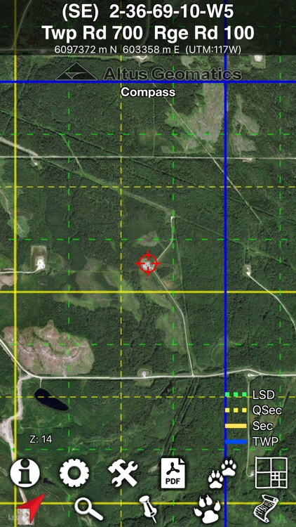
- Draws Twp lines to the Section level.
- Zooms to LSD, UTM or Lat/Long with route option.
- Manages pins including GPX import export.
Pro Package Features IAP ($159.99)
- Navigates showing offsets to Section boundaries as well.
- Navigates in geoRef PDF showing offsets as well.
- Navigates with left/right deviation from drawn course line.
- Draws Twp lines to the LSD level.
- Zooms to LSD, UTM, Lat/Long, NTS with route option.
- Manages pins & tracks.
- Loads multiple offline map layers at the same time.
- Selects background map (hybrid or roads).
- Creates notification targets (notify when inside the area).
- Creates a geofence (notify when outside the area).
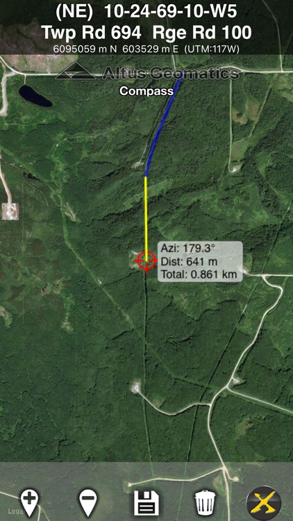
- Displays azimuth & distance to destination pin.
- Creates a manual route (with traverse distance and azimuth).
- Indexes Nav Photo at camera locations.
- Tracks movement with breadcrumb trail.
- Customizes pin properties.
Individual Features IAP (each @ $59.99)
- Positions a pad target with well center and flare azimuth. (Standard Required)
Individual Features IAP (each @ $29.99)
- Converts coordinates and transforms datum. (Standard Required)
- Imports and export KML/KMZ. (Pro Required)
- Creates 1:50000 National Topographic System (NTS) custom map layer, including contours, for current view. (Pro Required)
Sample combo IAP price matrix:
$0 Free
$59.99 Standard
$89.98 Standard + Convert
$119.98 Standard + Pad
$219.98 Standard + Pro
$249.97 Standard + Pro + KML
$279.96 Standard + Pro + KML + Convert
$279.96 Standard + Pro + KML + NTS
$279.97 Standard + Pro + Pad
$339.95 Standard + Pro + KML + NTS + Pad
$369.94 everything
To enable the display of LSD on map or geoRef PDF, the $59.99 Standard package in-app-purchase is required.
To activate that please tap the (i) info icon, then tap the "View In App Purchases" link in the middle of the info screen. Then inside the In App menu, tap the "Buy" link on the right of Standard features.
While the guidelines in the "Supplement to the Manual of Instructions for the Survey of Canada Lands" are followed, there is no warranty as to accuracy of the coordinate conversion. Intended as an aid to navigating the oil patch in the Prairie Provinces of Canada: Manitoba, Saskatchewan, Alberta and British Columbia, this app is not to be used for boundary determination for which a qualified land surveyor should be consulted. Users are responsible to ensure safety while driving and to follow all applicable legislation. Directions are not guaranteed correct. Altus takes no responsible for the accuracy or availability of third party data that extra features (such as Base Map and NTS maps) rely on.
WARNING: Prolonged navigation using the GPS will decrease the battery life of the device. It will also increase your data usage. Continued use of GPS running in the background can dramatically decrease battery life.
The cellular option for the iPad is required if you wish to use it for tracking. No data plan is required if base map satellite image is not desired.
Disclaimer:
AppAdvice does not own this application and only provides images and links contained in the iTunes Search API, to help our users find the best apps to download. If you are the developer of this app and would like your information removed, please send a request to takedown@appadvice.com and your information will be removed.
AppAdvice does not own this application and only provides images and links contained in the iTunes Search API, to help our users find the best apps to download. If you are the developer of this app and would like your information removed, please send a request to takedown@appadvice.com and your information will be removed.