You are using an outdated browser. Please
upgrade your browser to improve your experience.

Take this guide with you when riding the Mawson Trail

Mawson Trail Guide
by Find the Fun Pty Ltd


What is it about?
Take this guide with you when riding the Mawson Trail. It has all the information you need to navigate on and prepare for the Trail. It's built by Australians who have ridden the Trail and LOVE bike packing!
App Screenshots


App Store Description
Take this guide with you when riding the Mawson Trail. It has all the information you need to navigate on and prepare for the Trail. It's built by Australians who have ridden the Trail and LOVE bike packing!
The guide works 100% without needing mobile phone reception or Internet access. The offline maps are very detailed, show the Mawson Trail, show where you are via GPS, have contour lines, and are marked up with huts, camping areas, towns, alternative accommodation and many points of interest. The App map shows you how many kilometres you are from places like huts and towns, and has an interactive elevation graph so you can see what hills are between you and places.
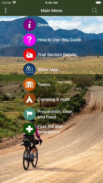
The App has advice on how to prepare for your trip, what gear to bring, what bike to ride and suitable food. It's a complete "how to do the trail" guide. It has many other features, photos and information, as described below.
FEATURES:
- Very detailed offline maps. They ALWAYS work, even when mobile phone coverage and Internet are not available.
- The map is tuned to look great on a small phone screen and show details that a cyclist in remote areas needs. You'll see details such as minor tracks and trails at zoom levels where most other maps hide them. So zoom out and tracks don't disappear from your map! This makes getting back to the trail easy if you loose it. And finding roads to bypass muddy sections becomes trivial. Great for your safety and easier for you to navigate even with a tiny screen.
- Uses GPS to show your location on the map.
- The map shows contour lines when you zoom in.
- The map has extra markers for huts, towns, camping areas, places where you can get food, attractions, and other points of interest.
- Tap places on the map and be shown your distance from them along the track. See how far away that town is!
- An elevation graph that you can zoom-and-swipe to see all the hills and valleys along the trail.
- The elevation graph shows your location and markers for towns other places. Do I have to ride up any big hills to get to that town?
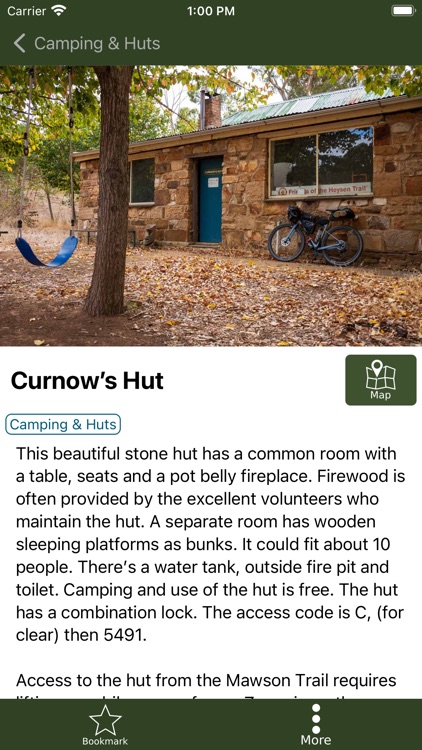
- Tap hut, town, camping and other markers on the map to get detailed information and photographs for those places.
- Has descriptions and pictures of each section of the Trail.
- Has a trail overview, and information about the huts, drinking water, safety, weather and history of places.
- Detailed advice and information on how to train for a multi-day trip, choosing a bike, when to ride, what gear you need and suitable food.
- Shows bike shops and other places that can supply bike parts or fix problems.
- Describes how to get and from endpoints of the Mawson Trail.
- No mobile phone coverage or internet is needed for the App to work. Put your phone in Airplane Mode to save battery power and continue to use the App (your phone's GPS will still work in Airplane Mode).
- The App turns off GPS when the screen is turned off, so will not use phone power when you are not using it.
- The guide has loads of beautiful photographs of the Trail to inspire you!
You will never get lost because the maps always work and show you where you are, even when you stray from the Trail. The great detail on the maps make it easy to follow bush tracks and paths to get back to the Trail.
This App was built by a small Western Australian software company. We've ridden the Trail and have extensive bike packing experience. We're confident our Mawson Trail Guide App will make your trip easier to plan, safer and more fun.
Disclaimer:
AppAdvice does not own this application and only provides images and links contained in the iTunes Search API, to help our users find the best apps to download. If you are the developer of this app and would like your information removed, please send a request to takedown@appadvice.com and your information will be removed.
AppAdvice does not own this application and only provides images and links contained in the iTunes Search API, to help our users find the best apps to download. If you are the developer of this app and would like your information removed, please send a request to takedown@appadvice.com and your information will be removed.