You are using an outdated browser. Please
upgrade your browser to improve your experience.

The Universal Transverse Mercator coordinate system was developed by the United States Army Corps of Engineers in the 1940s

Mercator Projector - direct & inverse solution of UTM Projection
by Jian Li

What is it about?
The Universal Transverse Mercator coordinate system was developed by the United States Army Corps of Engineers in the 1940s. The system was based on an ellipsoidal model of Earth. For areas within the contiguous United States the Clarke Ellipsoid of 1866 was used. For the remaining areas of Earth, including Hawaii, the International Ellipsoid was used. The WGS84 ellipsoid is now generally used to model the Earth in the UTM coordinate system, which means current UTM northing at a given point can be 200+ meters different from the old. For different geographic regions, other datum systems (e.g.: ED50, NAD83) can be used.
App Screenshots

App Store Description
The Universal Transverse Mercator coordinate system was developed by the United States Army Corps of Engineers in the 1940s. The system was based on an ellipsoidal model of Earth. For areas within the contiguous United States the Clarke Ellipsoid of 1866 was used. For the remaining areas of Earth, including Hawaii, the International Ellipsoid was used. The WGS84 ellipsoid is now generally used to model the Earth in the UTM coordinate system, which means current UTM northing at a given point can be 200+ meters different from the old. For different geographic regions, other datum systems (e.g.: ED50, NAD83) can be used.
Prior to the development of the Universal Transverse Mercator coordinate system, several European nations demonstrated the utility of grid-based conformal maps by mapping their territory during the interwar period. Calculating the distance between two points on these maps could be performed more easily in the field (using the Pythagorean theorem) than was possible using the trigonometric formulas required under the graticule-based system of latitude and longitude. In the post-war years, these concepts were extended into the Universal Transverse Mercator / Universal Polar Stereographic (UTM/UPS) coordinate system, which is a global (or universal) system of grid-based maps.
[UTM zone]
Simplified view of US UTM zones, projected with Lambert conformal conic.
The UTM system divides the Earth between 80°S and 84°N latitude into 60 zones, each 6° of longitude in width. Zone 1 covers longitude 180° to 174° W; zone numbering increases eastward to zone 60, which covers longitude 174° to 180° E.
Each of the 60 zones uses a transverse Mercator projection that can map a region of large north-south extent with low distortion. By using narrow zones of 6° of longitude (up to 800 km) in width, and reducing the scale factor along the central meridian to 0.9996 (a reduction of 1:2500), the amount of distortion is held below 1 part in 1,000 inside each zone. Distortion of scale increases to 1.0010 at the zone boundaries along the equator.
In each zone the scale factor of the central meridian reduces the diameter of the transverse cylinder to produce a secant projection with two standard lines, or lines of true scale, about 180 km on each side of, and about parallel to, the central meridian (Arc cos 0.9996 = 1.62° at the Equator). The scale is less than 1 inside the standard lines and greater than 1 outside them, but the overall distortion is minimized.
[Features]
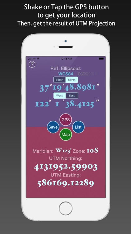
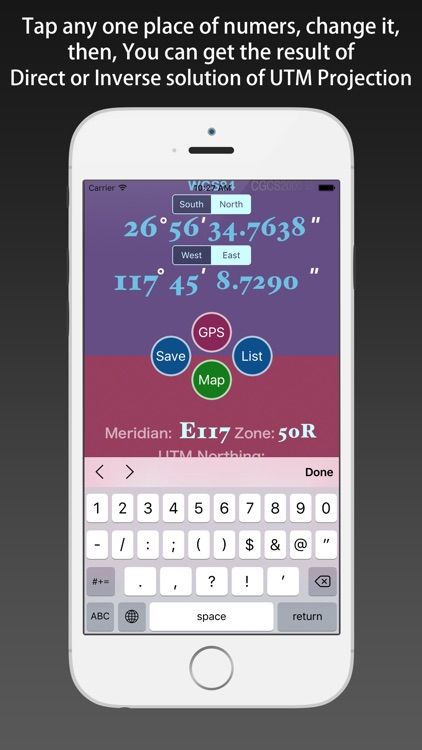
1) support direct and inverse solution of UTM Projection.
2) support several types of reference ellipsoid.
3) support using GPS to get the location, and transform it to UTM coordinate.
4) support moving the pin on the map to obtain the latitude and longitude of the location, and transform them.
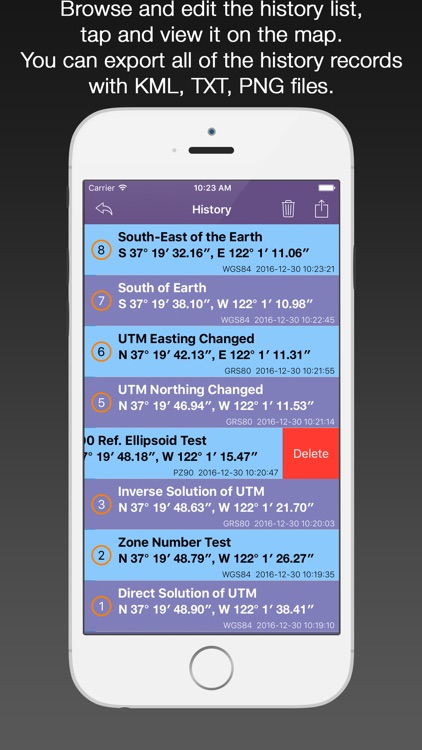
5) support saving the UTM projection results, and the history records can be viewed, deleted, cleaned up, and shared.
6) Every the historical record can be shown on the map, and each of them can be reduced again.
[Location Input Method]
1) using the keyboard input by hand.
2) using the GPS positioning.
3) moving the pin on the map.
4) shake your iOS device.
[Instructions]
Direct solution of the UTM Projection:
1) Select the Reference Ellipsoid.
2) Tap the “GPS” button to get the location.
3) Or Input the location using keyboard.
4) Inputed the number, tap the “Done” button, then you can get the UTM Coordinate.
Inverse solution of the UTM Projection:
1) Select the Reference Ellipsoid.
2) Input the zone number.
3) Input the UTM Coordinate components (Northing, Easting).
4) Inputed the number, tap the “Done” button, then you can get the Geodetic Coordinate.
Disclaimer:
AppAdvice does not own this application and only provides images and links contained in the iTunes Search API, to help our users find the best apps to download. If you are the developer of this app and would like your information removed, please send a request to takedown@appadvice.com and your information will be removed.
AppAdvice does not own this application and only provides images and links contained in the iTunes Search API, to help our users find the best apps to download. If you are the developer of this app and would like your information removed, please send a request to takedown@appadvice.com and your information will be removed.