You are using an outdated browser. Please
upgrade your browser to improve your experience.
Marine Mammal Observers mitigate for the potential impact of sound exposure on marine fauna during geophysical surveys, naval active-sonar exercises, UXO clearance or civil engineering projects

MMO Range Finder
by James Keating

What is it about?
Marine Mammal Observers mitigate for the potential impact of sound exposure on marine fauna during geophysical surveys, naval active-sonar exercises, UXO clearance or civil engineering projects.
App Screenshots

App Store Description
Marine Mammal Observers mitigate for the potential impact of sound exposure on marine fauna during geophysical surveys, naval active-sonar exercises, UXO clearance or civil engineering projects.
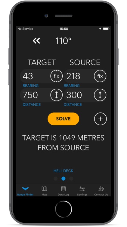
This app will assist the MMO making mitigation decisions by calculating the distance from the animal to the source of acoustic interference using a trigonometric cosine function. The MMO simply enters the distance and bearing to the TARGET and SOURCE from their observation position and the app calculates the rest.
This app is loaded with features to make allow to keep focused on the detection (See the user manual for a detailed description):
Fix compass bearing to animal and source by pointing device and pressing button.
Convert binocular reticules to distance by entering the number of reticules between horizon and animal and pressing the reticule button (per formulae in Lerczack and Hobbs, 1998).
Set up to 3 unique observation locations to define height above sea level (required for accurate reticule conversion).
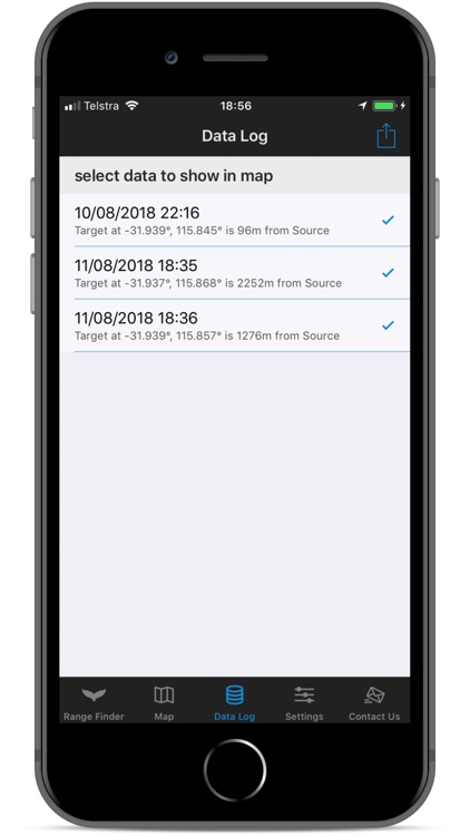
Save data to the log for each sighting and export in .csv format for your own mapping and analyses needs.
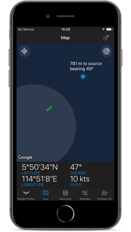
Shows vessel position, mitigation zone and projected fauna sightings on the map. Map also displays latitude, longitude, course and speed.
Press the radar button and the map will orientate to the vessel point of view. Sightings labels will be updated live with the distance to source and the bearing from the vessel for ease of re-sighting.
Fully customise the MMO parameters. Specify anything from your binocular MILs per reticule, mitigation zone size, choose a ramform hull as your maps ship symbol and much much more!
Disclaimer:
MMO Range Finder App should be used as a reference tool and is only as precise as the users ability to range find. Any decision making is the responsibility of the user. If in use, the compass and GPS location should be verified often.
Disclaimer:
AppAdvice does not own this application and only provides images and links contained in the iTunes Search API, to help our users find the best apps to download. If you are the developer of this app and would like your information removed, please send a request to takedown@appadvice.com and your information will be removed.
AppAdvice does not own this application and only provides images and links contained in the iTunes Search API, to help our users find the best apps to download. If you are the developer of this app and would like your information removed, please send a request to takedown@appadvice.com and your information will be removed.