You are using an outdated browser. Please
upgrade your browser to improve your experience.
rRuf ('Road Roughness') is a mobile application that allows managers, engineers, technicians, or the travelling public to measure a userís response to the roughness of a road and reported in a scale known as a Riding Comfort Index (RCI)

rRuf
by Rival Solutions
What is it about?
rRuf ('Road Roughness') is a mobile application that allows managers, engineers, technicians, or the travelling public to measure a userís response to the roughness of a road and reported in a scale known as a Riding Comfort Index (RCI). Ride comfort, from roughness, is a function of the road surface condition and underlying structural adequacy, and is a key quality indicator for roadway engineers and managers. Road roughness directly impacts vehicle and transportation user costs. The rRuf app is used as part of a larger cloud based infrastructure management process, called RUBIX.
App Store Description
rRuf ('Road Roughness') is a mobile application that allows managers, engineers, technicians, or the travelling public to measure a userís response to the roughness of a road and reported in a scale known as a Riding Comfort Index (RCI). Ride comfort, from roughness, is a function of the road surface condition and underlying structural adequacy, and is a key quality indicator for roadway engineers and managers. Road roughness directly impacts vehicle and transportation user costs. The rRuf app is used as part of a larger cloud based infrastructure management process, called RUBIX.
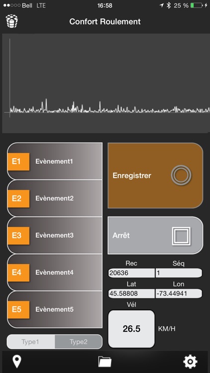
rRuf automatically records and transfers raw data through RUBIX cloud services to produce a response based road roughness condition rating. This is accomplished through the aggregation and processing of location (GNSS), motion (acceleration) and base centerline mapping data within the RUBIX workflow.
In all, rRuf and the RUBIX utility provide infrastructure and roadway managers a turn-key solution for evaluating roadway infrastructure condition. To leverage the full functionality of rRuf, users need to have an active RUBIX subscription.
rRuf produces raw data and when processed by the RUBIX servers, the following results can be optioned nearly instantaneously from a web dashboard:
-Roughness and Ride Comfort Index (eg scale of 1-10) color-coded;
-Results that are reported by an input map (i.e. block to block, milepost,etc);
-Results reported in smaller intervals (eg 100 meters);
-Overall production maps indicating what roads have been driven with a score or not;
-Statistical information (avg, min, max, stdev) for each segment for data such as speed and acceleration;
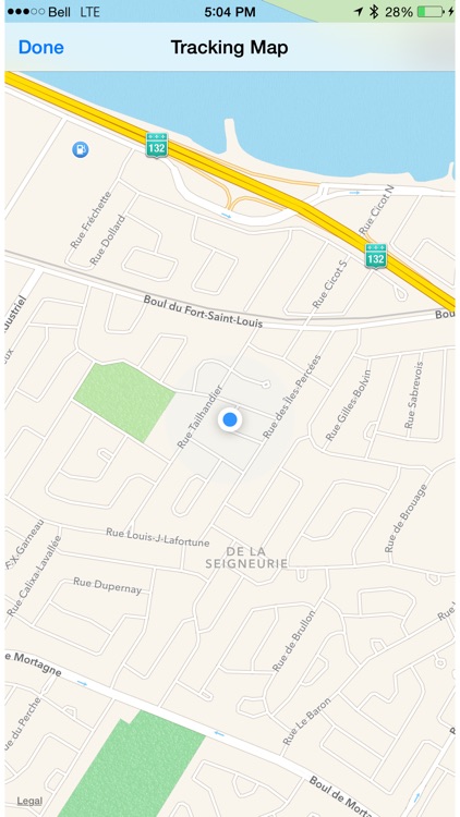
-Breadcrumb trail of the vehicles location;
-Event locations logged in the app.
The rRuf app itself provides the following functionality:
- Recording of geolocated acceleration raw data to csv files;
- Manual roadway geolocated information entries (events and types);
- Auto pause during vehicle stops;
- Manual and automated emailing of recorded data.
- Location maps;
- Sampling frequency configuration;
- Project specific configuration fields;
- Auto compression of data files.
Disclaimer:
AppAdvice does not own this application and only provides images and links contained in the iTunes Search API, to help our users find the best apps to download. If you are the developer of this app and would like your information removed, please send a request to takedown@appadvice.com and your information will be removed.
AppAdvice does not own this application and only provides images and links contained in the iTunes Search API, to help our users find the best apps to download. If you are the developer of this app and would like your information removed, please send a request to takedown@appadvice.com and your information will be removed.