You are using an outdated browser. Please
upgrade your browser to improve your experience.
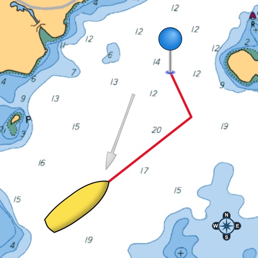
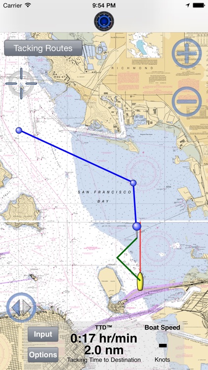
Display your optimal tacks on a chart, and the exact distance and time on each tack

SailTimer Charts Edition™
by SailTimer Inc.
What is it about?
Display your optimal tacks on a chart, and the exact distance and time on each tack. Standard GPS chartplotters and mapping apps do not account for tacking distances. But if they do not know the distance you will travel, how can they calculate your correct ETA? SailTimer gives you a quick and easy display of your optimal tacks and TTD® (Tacking Time to Destination).
SailTimer Charts Edition™ is FREE but there are more add-ons
-
$7.99
SailTimer Pro Bundle
-
Free
ActiveCaptain
-
$15.99
USA Atlantic Coast
-
$3.99
Routes
-
$15.99
USA Gulf Coast
-
$3.99
Tracking
-
$9.99
Polar Learning
-
$15.99
USA Great Lakes
-
$15.99
USA Pacific Coast
-
$15.99
Cuba, Bahamas, Puerto Rico and US Virgin Islands
App Store Description
Display your optimal tacks on a chart, and the exact distance and time on each tack. Standard GPS chartplotters and mapping apps do not account for tacking distances. But if they do not know the distance you will travel, how can they calculate your correct ETA? SailTimer gives you a quick and easy display of your optimal tacks and TTD® (Tacking Time to Destination).
This free Charts Edition includes all of the same features as the SailTimer app, although a few are optional in-app purchases here (a la carte).
Simply enter the directions of the wind and your destination along with the wind speed to get the optimal tacking angles.
Operating Instructions and Unique Features:
• Worldwide vector charts: If you have the Navionics Boating app, you can also use the same charts here with a yearly subscription. Navionics terms of use: SailTimerApp.com/vectorcharts.html. Payment will be charged to iTunes Account at confirmation of purchase. Subscription automatically renews unless auto-renew is turned off in iTunes Account Settings at least 24-hours before the end of the current period. Account will be charged for renewal within 24-hours prior to the end of the current period, with the same cost for renewing the subscription again.
• Marine charts (raster) based on the paper charts are also available as low-cost in-app purchases for USA, US Virgin Islands, Puerto Rico, large-scale charts of The Bahamas and Cuba, and New Zealand. Aerial photos and road maps worldwide are available free. All can be used offline.
• The white crosshair icon in the top left is the “Follow-Me” button. If clicked, it turns blue and keeps your location in the center of the screen as you move. Unselect when not moving to look around the map, and when you want to zoom in and out.
• Mark waypoints on the map. Then easily display the optimal tacks, tacking distances, headings and times to get to that waypoint. In-app purchase enables naming of waypoints.
• The app works great with our wireless Wind Instrument (www.SailTimerWind.com).
• Audio Navigation: when using the wireless Wind Instrument, optionally hear wind conditions or boat speed when they change by more than a set amount. It is like having a tactician in the cockpit with you. You can put your iPhone/iPad away safe and dry, and use a Bluetooth speaker or earbuds. Keep your hands and eyes free for sailing — no screen required. You can even shut off the screen to reduce heat and power consumption, and continue to hear audio reports.
• Enlarge the unique Wind Speedometer to keep an eye on wind gusts if using Wind Instrument. If you want a record of wind speeds, click the Graph button and you can save or share a graph showing your boat speed and wind speed. The graph saves these for up to 24 hours as long as the device is not rebooted.
• Your device will not go to sleep when the app is open, to allow you to continue to monitor your progress on the chart. You can also continue to track your tacking results with the app running in the background or when the device is asleep (unless you hard-quit).
• Click on the pin at the end of a pair of tacks to see the distances, heading and time on each tack.
• Custom polar plots: This in-app purchase allows the app to learn your unique sailboat's speed profile on all points of sail, for the most accurate tacking results.
• Switch to the port or starboard tack to avoid obstructions, or let the app automatically display the tack nearest to your current heading.
• GPS tracks can be saved, imported or emailed with an in-app purchase, to show others where you went.
• Convert from Apparent to True wind speed & direction.
Continued use of GPS running in the background can dramatically decrease battery life.
If you are getting this free app and agree that these are helpful features for sailing, please help out other sailors by letting them know, with a quick rating on this version while you’re here.
Disclaimer:
AppAdvice does not own this application and only provides images and links contained in the iTunes Search API, to help our users find the best apps to download. If you are the developer of this app and would like your information removed, please send a request to takedown@appadvice.com and your information will be removed.
AppAdvice does not own this application and only provides images and links contained in the iTunes Search API, to help our users find the best apps to download. If you are the developer of this app and would like your information removed, please send a request to takedown@appadvice.com and your information will be removed.