You are using an outdated browser. Please
upgrade your browser to improve your experience.
This is a simple geosynchronous satellite coverage slide rule

SatCalc
by ArgoSat Consulting LLC
What is it about?
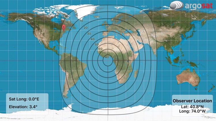
This is a simple geosynchronous satellite coverage slide rule. It calculates the elevation angle for a given latitude and longitude on the earth, to correctly point to a geosynchronous satellite at another longitude. It also shows graphically the coverage area on the earth for a satellite at a given longitude in geosynchronous orbit, and whether or not the satellite will be in view.
App Store Description
This is a simple geosynchronous satellite coverage slide rule. It calculates the elevation angle for a given latitude and longitude on the earth, to correctly point to a geosynchronous satellite at another longitude. It also shows graphically the coverage area on the earth for a satellite at a given longitude in geosynchronous orbit, and whether or not the satellite will be in view.
If authorized, at start the app will drop a pin on the map with the current users location. Long press to add a pin at a different location. Drag the pin to the latitude/longitude desired. Then slide the screen to place the satellite at the correct longitude. Elevation angle is computed based on location of the pin and location of the satellite.
Disclaimer:
AppAdvice does not own this application and only provides images and links contained in the iTunes Search API, to help our users find the best apps to download. If you are the developer of this app and would like your information removed, please send a request to takedown@appadvice.com and your information will be removed.
AppAdvice does not own this application and only provides images and links contained in the iTunes Search API, to help our users find the best apps to download. If you are the developer of this app and would like your information removed, please send a request to takedown@appadvice.com and your information will be removed.