You are using an outdated browser. Please
upgrade your browser to improve your experience.

The UoB Campus map has been designed to help students, staff and visitors find their way around the University of Birmingham Edgbaston & Selly Oak Campus

UoB Campus Map
by Smart Networked Environments Ltd

What is it about?
The UoB Campus map has been designed to help students, staff and visitors find their way around the University of Birmingham Edgbaston & Selly Oak Campus.
App Screenshots

App Store Description
The UoB Campus map has been designed to help students, staff and visitors find their way around the University of Birmingham Edgbaston & Selly Oak Campus.
Building to building navigation, study space locations, café opening times and event updates have all been consolidated within the digital campus map.
Obtain useful travel advice on the various means of getting to and from the campuses including real-time bus and train information and supporting information on the location of cafés, shops and toilets.
In conjunction with the University's disabled access forum, the flexible routing capabilities have been used to ensure appropriate paths are selected for impaired mobility users. On occasions when paths or facilities (e.g. lifts or stairs) are closed, the system automatically takes this into account when calculating the best path.
Please use the feedback form within the settings menu to send us any issues, suggestions or comments to be considered in preparation for the next release.
Summary of Key Features:
Quick search: shows the location of any building or facility on campus with extra information options for key locations.
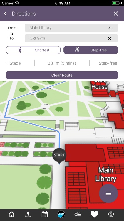
Directions: Navigation given to any location from any point on campus with the route plotted on the campus map. Stair-free routing can be selected prior to running a search, please access settings to adjust your preferences.
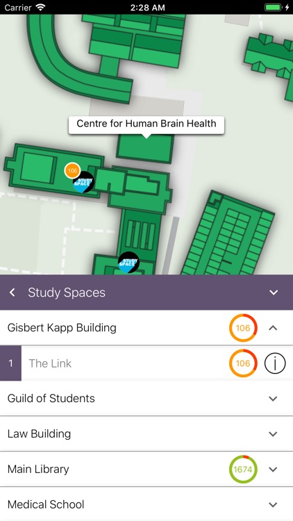
Study Space: Quickly identify the best locations to study on campus.
Additional Categories: Cafes, shops, toilets and bus stops can be selected and the relevant icons will be displayed on the map indicating their position. Further information such as opening times, photos and links to location web sites can be obtained by touching the icon.
Events: University event details can be viewed and listed by date, category and venue. Navigation is given to the venue hosting the event. Event Information is taken from the central University webpages.
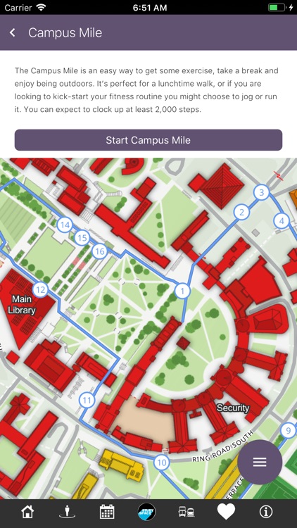
Campus Mile: The campus mile is an easy way to get some exercise, take a break and enjoy some exercise. It's perfect for a lunchtime walk, or if you are looking to kick-start your fitness routine you might choose to jog or run it. You can expect to clock up at least 2,000 steps.
Disclaimer:
AppAdvice does not own this application and only provides images and links contained in the iTunes Search API, to help our users find the best apps to download. If you are the developer of this app and would like your information removed, please send a request to takedown@appadvice.com and your information will be removed.
AppAdvice does not own this application and only provides images and links contained in the iTunes Search API, to help our users find the best apps to download. If you are the developer of this app and would like your information removed, please send a request to takedown@appadvice.com and your information will be removed.