You are using an outdated browser. Please
upgrade your browser to improve your experience.

VFRnav is a navigation application specifically designed to meet the needs of pilots flying under visual flight rules (VFR)

VFRnav Flight Navigation
by Hermann Hoelter
What is it about?
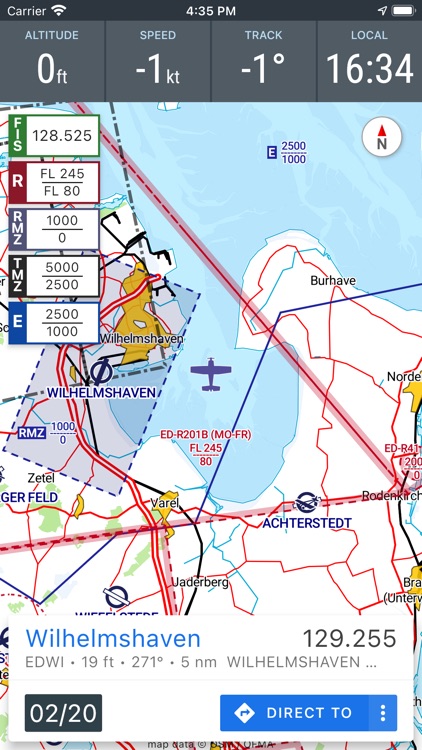
VFRnav is a navigation application specifically designed to meet the needs of pilots flying under visual flight rules (VFR). The app combines a moving map in ICAO style with comprehensive planning and recording features, enabling reliable and efficient flight navigation.
App Store Description
VFRnav is a navigation application specifically designed to meet the needs of pilots flying under visual flight rules (VFR). The app combines a moving map in ICAO style with comprehensive planning and recording features, enabling reliable and efficient flight navigation.
Key Features:
• Map-Based Navigation: Displays flight routes on an ICAO-style map with real-time position updates.
• Offline Operation: Fully functional offline after setup; no active internet connection required during flight.
• Database: Comprehensive information on airports, waypoints, and navigation aids across numerous European countries.
• Flight Planning: Assists with route planning, fuel calculation, and flight time estimation. Automatically integrates weather data and NOTAMs for the planned route.
• Digital Flight Logbook: Automatically records takeoff and landing times. Export flight data as KML files for use in applications like Google Maps.
• External Sensors: Supports integration with external GPS receivers and traffic data sources (e.g., FLARM, Stratux, CCAS, SafeSky, ADS-B) via WiFi or Bluetooth.
License Model:
VFRnav can be fully tested without restrictions before purchase. A license costs €49.95 and provides access to one year of free updates. After the initial period, the update term can be renewed. The app remains fully functional regardless of updates.
Disclaimer:
The accuracy and completeness of the provided information cannot be guaranteed. Use is at your own risk. Data displayed in the app should always be validated against official aviation charts.
Disclaimer:
AppAdvice does not own this application and only provides images and links contained in the iTunes Search API, to help our users find the best apps to download. If you are the developer of this app and would like your information removed, please send a request to takedown@appadvice.com and your information will be removed.
AppAdvice does not own this application and only provides images and links contained in the iTunes Search API, to help our users find the best apps to download. If you are the developer of this app and would like your information removed, please send a request to takedown@appadvice.com and your information will be removed.