You are using an outdated browser. Please upgrade your browser to improve your experience.

Aviation Weather Forecast Apps

Not every app is for the casual consumer. These apps re designed for pilots, air traffic controllers, and flight planners. Each app offers the conditions for takeoffs, landings, and at tens of thousands of feet.

StationWeather - METAR and TAF
ForeFlight Mobile EFB
Easy Aviation Weather - WX
WingX
AeroPlus Aviation Weather

Best Apps

Highest scored apps in the category

StationWeather - METAR and TAF

StationWeather

Oliver Puetz

- METARs, TAFs, ATIS, NOTAMs, Weather Radar and more

- METARs, TAFs, ATIS, NOTAMs, Weather Radar and more
- Decoded weather reports for faster and better briefings
- Live TAF breaks down forecast assessment to a matter of seconds
- Stay up to date with widgets and Apple Watch complications

Forget raw weather reports.

When you go flying with StationWeather, you will speed up your weather briefing to a few seconds, while getting an...

ForeFlight Mobile EFB

ForeFlight Mobile EFB

ForeFlight

Download for a 30-day free trial

Download for a 30-day free trial. ForeFlight is the essential, integrated flight app that makes planning, flying, and logging flights a joy.

ForeFlight delivers advanced flight planning capabilities, terminal procedure charts, enroute navigation charts, moving map, synthetic vision, hazard awareness, optional Jeppesen charts, a comprehensive library of market-leading weather information and visualization features, a large library of advanced aircraft performance profiles,...

Easy Aviation Weather - WX

Easy Aviation Weather

Free-Flight-Aviation Ltd.

Get real-time airport weather data (Aviation WX/METAR/TAF/NOTAM) directly to your iPhone and iPad

Get real-time airport weather data (Aviation WX/METAR/TAF/NOTAM) directly to your iPhone and iPad. Search for weather stations and airports all over the World (FAA, EASA,...). Easy Aviation Weather - WX is a quick and simple solution to make your flights as safe as possible.

This application is designed to provide aviation weather information for pilots including the followings:

- Current weather...

WingX
WingX

WingX

Hilton Software LLC

WingX Pro7's simple subscription model:

WingX Pro7's simple subscription model:
● VFR Free! and MilitaryFree! - only VFR flying or Active or Retired Military? Subscription is free.
● $74.95 annual subscription (or $199.95 for 3 years)
● $74.95 for Advanced IFR Subscription
● Free: 30-day Free Period
● Free: Synthetic Vision and Fuel Prices (with current subscription)

Annual Subscription
Includes VFR Sectionals, IFR Enroute Low and High, TACs, Flyway, Helicopter, Grand Canyon,...

Also Good

Apps with average score

AeroPlus Aviation Weather

AeroPlus Aviation Weather

Magnolia Blossom BV

This aviation weather app brings professional weather forecasting features to every serious pilot.

The app presents pilots with the well known METAR and TAF data in an intuitive and visual way.

Scroll over the map to the area you are interested in and get a good overview of the expected weather in...

Wx24 Pilot
Wx24 Pilot
Wx24 Pilot

Wx24 Pilot

Concept Elements LLC

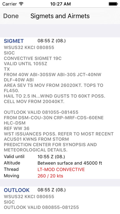
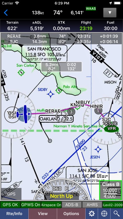
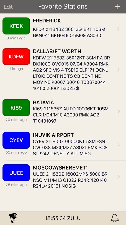
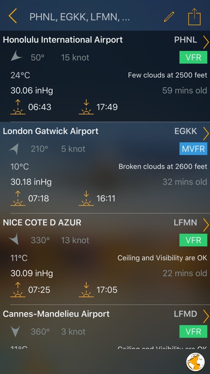
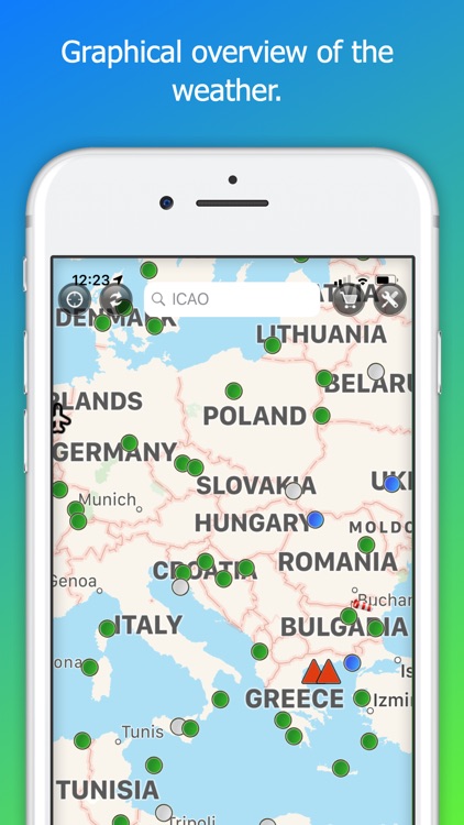
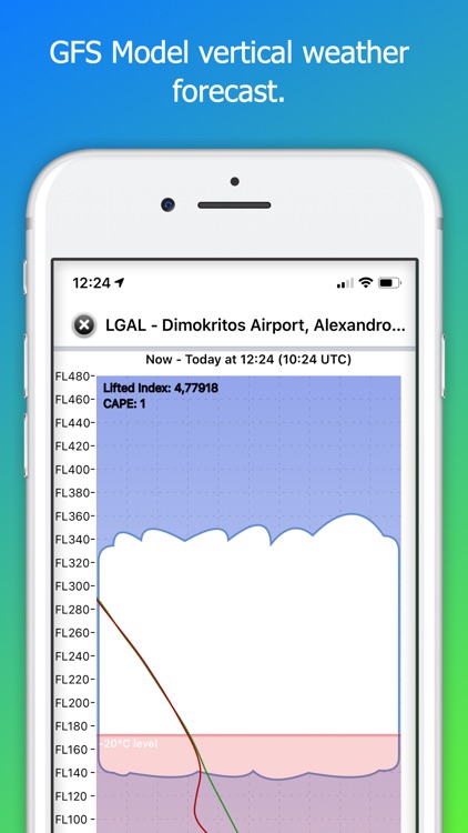
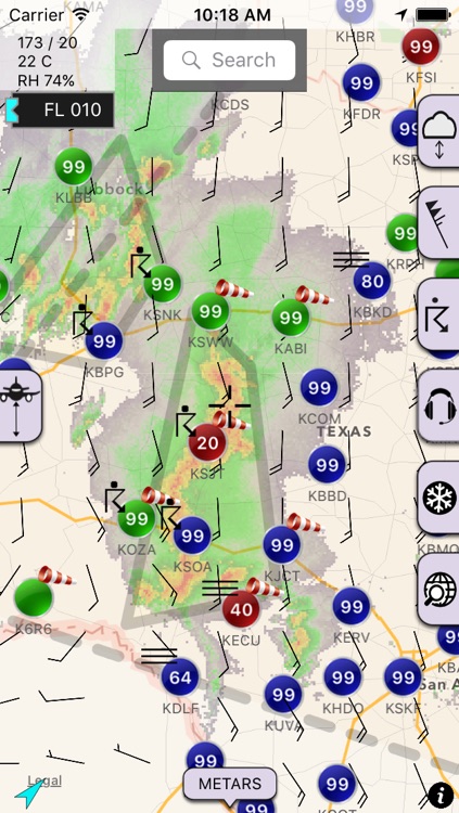
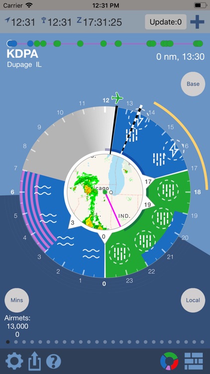
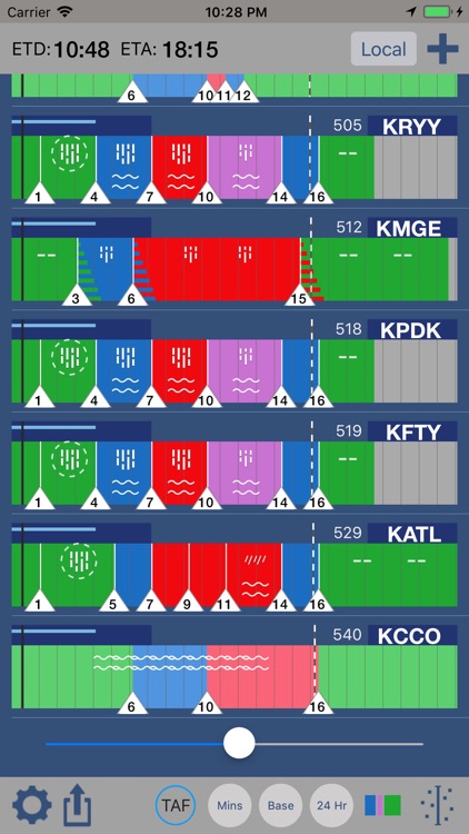
Wx24 Pilot is an Aviation Weather App that simplifies the process of reading and understanding aviation weather reports by visually representing TAFs, Air/Sigmets, METARs, TFRS with other weather data.

There is a free version that allows for 5 location and a premium subscription that gives the following:

SUBSCRITION FEATURES:
• Personal Minimums...

Sky MET (free)
Sky MET (free)
Sky MET (free)

Sky MET (free)

Sparkling Apps

Welcome to Sky MET,

The ultimate weather app for pilots, by pilots.
This visually stunning and feature rich application provides you with all the weather information you will need when you prepare for your next flight:

METARs and TAFs with a twist
Sure you can get TAFs and METARs everywhere, but you'd...

AeroWeather Lite
AeroWeather Lite
AeroWeather Lite

AeroWeather Lite

Lakehorn AG

*** AeroWeather: for pilots, aviation enthusiasts, and everyone who is serious about the weather!
*** Current and precise weather conditions (METAR) and forecasts (TAF).

AeroWeather Lite provides quick and intuitive access to METAR and TAF for airports worldwide. Data can be shown in its original (raw) format or as fully decoded and...

NOAA Aviation Live Sky Weather

NOAA Aviation Live Sky Weather

Andrea Bisegna

Get real-time airport weather data NOAA/NWS/NEC/AWC directly to your iPhone and iPad.

Search for weather stations and airports all over the World.

- More than 100.000 weather stations available
- Check the weather stations directly from the map
- Search weather station or airport by name, description, region, US state, or geolocation (latitude,...

METARs Aviation Weather

METARs Aviation Weather

Aviation Mobile Apps, LLC.

Congratulations, you have found the finest METAR & TAF monitoring, reporting, and alert system designed for your iPhone, iPad, Apple Watch, and Apple TV.

METARs Aviation Weather provides a quick and convenient way to access the world's most trusted routine weather reports, the Meteorological Terminal Aviation Routine Weather Report (METAR) and...

Aviation Weather Group Manager

Aviation Weather Group Manager

Flygo-Aviation Ltd

Thanks to everyone for making FlyGo-Aviation apps so successful, with over 100.000 downloads!

Create any groups related to your flights. Aviation Weather Group Manager - METAR, NOTAM provides accurate live information about aviation weather specially for pilots.

The application contains the following WX features:
- Worldwide Airport weather stations (offline)
- Current weather -...

WSI Pilotbrief Optima

WSI Pilotbrief Optima

WSI Corporation

On the ground or in the air, Pilotbrief Optima is your co-pilot in the cockpit. Fly safely, confidently and comfortably with the latest and most accurate weather at your fingertips.

From any location, quickly create or select a flight route, retrieve a weather briefing, access enroute weather and modify the route...

WX Charts Europe
WX Charts Europe
WX Charts Europe

WX Charts Europe

S M Sidat

WX Charts Europe presents various weather charts useful to pilots or anyone interested in flight planning. Three categories of charts are presented:

• Synoptic charts - 0600 to 1800 for the current day and forecasts up to +120 Hours

• Significant weather charts - latest at 0600 to 1800.

• Wind & temperature...

WX Charts Europe for iPad

WX Charts Europe for iPad

S M Sidat

WX Charts Europe for the iPad! Now you can view & share your weather charts on the iPad.

WX Charts Europe presents various weather charts useful to pilots or anyone interested in flight planning.

• Synoptic charts - 0600 to 1800 for the current day and forecasts up to +120 Hours

•...

Aviation weather
Aviation weather
Aviation weather

Aviation weather

Udo Riedel

Weather briefing for your pocket - from pilots for pilots.

Aviation weather - The App allows you to easily get weather related information for pilots.

Features:
• Get METAR, TAF, SIGMET, SIGWX charts and many more
• Cleary represented METAR, TAF and station data
• Current weather on map view
• Use all...

AirWX Aviation Weather

AirWX Aviation Weather

Mobile Dev Group LLC

Aviation weather for Pilots. Retrieve METARs, TAFs, and Weather Charts for airports in the US. Also includes access to sectional charts and displays a list of nearest airports to your location.

Features:
-METARs, TAFs, PIREPs, NOTAMs, and Winds Aloft
-Nearest Airports using GPS
-Search by City/State, name or Airport Identifier

If you have any other...

Other Apps

Could be good for special cases

Takeoff - Aviation Weather

Takeoff - Aviation Weather

Higher Bar, LLC

PUT YOUR SAFETY FIRST
Takeoff is the only aviation weather app to understand that you want to fly safe, in weather that YOU feel comfortable with. Takeoff gives easy-to-see, color-coded warnings and information based on your own personal minimums; Takeoff understands what the sky looks like to you, not to some computer. Combining accurate and reliable data from official sources, Takeoff is a trusted tool used by pilots the world over.

Takeoff makes it easy to find the airport you need:
• Find airports near your current location using GPS
• Find airports along a route
• Find airports in a region
• Save a list of your favorite airports for quick access

With list and map-based views of the weather, Takeoff gives you a high level view in any region instantly.

TAKEOFF KEEPS YOU SAFE
75% of fatal weather-related accidents start with pilots voluntarily flying into poor weather. Takeoff helps you to easily and reliably understand if the weather is right for YOU. Get personalized warnings based on cloud ceilings, visibility, total winds, runway crosswinds temperatures, dew point spread, density altitude, and more! By providing clear warnings based on your personal minimums, Takeoff helps you stay disciplined and keeps you from becoming a statistic.

INTUITIVE DESIGN
Find what you want without hassle:
• Personalized METAR reports, with full wind components and preferred runway
• Color-coded TAF display
• NOTAMs for airports around the globe
• METAR History
• Winds Aloft, AIRMETs, SIGMETs and PIREPs (U.S. Only)
• Hundreds of global weather graphics, including Animated Radar
• AF/D Page (U.S. Only)
• Metric and Imperial unit support
• Support for 3D Touch for iPhone 6s and 6s Plus: Peek and pop through reports and weather graphics, and use home screen shortcuts to quickly view the forecasts you want

TAKEOFF SAVES YOU TIME
Takeoff calculates crosswinds for every runway and gives personalized warnings based on limits dictated by YOU. Takeoff even provides shortcuts to common websites to allow you to quickly file flight plans and look up TFRs.

IDEAL FOR THE COCKPIT
Takeoff keeps the most recent reports ready and available on your device, so that you always have the information you need, even when you’re offline!

TRUSTED BY PILOTS. DEVELOPED BY PILOTS.
Takeoff was developed by pilots like you, who understand what information you need to fly safely. Other pilots agree:

"I love the presentation of information on the screen. The colors are great and the interpretations are pretty much idiot proof." -Adam Zucker, Pilot

"First thing I thought was WOW! I love how quick it is to get the information quickly into my brain. Love the maps and other weather graphics. Love the TAF decoder." -Andrew Ohnstad, Pilot

Takeoff relies on NOAA METAR and TAF reports. Airports must report METAR/TAF information in order for Takeoff to provide reports. Takeoff is not a substitute for official flight planning and weather information, and by using Takeoff, you agree not to hold the developers liable for any inaccuracies or misrepresentations.

Takeoff HD - Aviation Weather

Takeoff HD - Aviation Weather

Higher Bar, LLC

PUT YOUR SAFETY FIRST
Takeoff is the only aviation weather app to understand that you want to fly safe, in weather that YOU feel comfortable with. Takeoff gives easy-to-see, color-coded warnings and information based on your own personal minimums; Takeoff understands what the sky looks like to you, not to some computer. Combining accurate and reliable data from official sources, Takeoff is a trusted tool used by pilots the world over.

Takeoff makes it easy to find the airport you need
• Find airports near your current location using GPS
• Find airports along a route
• Find airports in a region
• Save a list of your favorite airports for quick access

With list and map-based views of the weather, Takeoff gives you a high level view in any region instantly.

TAKEOFF KEEPS YOU SAFE
75% of fatal weather-related accidents start with pilots voluntarily flying into poor weather. Takeoff helps you to easily and reliably understand if the weather is right for YOU. Get personalized warnings based on cloud ceilings, visibility, total winds, runway crosswinds temperatures, dew point spread, density altitude, and more! By providing clear warnings based on your personal minimums, Takeoff helps you stay disciplined and keeps you from becoming a statistic.

INTUITIVE DESIGN
Find what you want without hassle:
• Personalized METAR reports, with full wind components and preferred runway
• Color-coded TAF display
• NOTAMs for airports around the globe
• METAR History
• Winds Aloft, AIRMETs, SIGMETs and PIREPs (U.S. Only)
• Hundreds of global weather graphics, including Animated Radar
• AF/D Page (U.S. Only)
• Metric and Imperial unit support

TAKEOFF SAVES YOU TIME
Takeoff calculates crosswinds for every runway and gives personalized warnings based on limits dictated by YOU. Takeoff even provides shortcuts to common websites to allow you to quickly file flight plans and look up TFRs.

IDEAL FOR THE COCKPIT
Takeoff keeps the most recent reports ready and available on your device, so that you always have the information you need, even when you’re offline!

TRUSTED BY PILOTS. DEVELOPED BY PILOTS.
Takeoff was developed by pilots like you, who understand what information you need to fly safely. Other pilots agree:

"I love the presentation of information on the screen. The colors are great and the interpretations are pretty much idiot proof." -Adam Zucker, Pilot

"First thing I thought was WOW! I love how quick it is to get the information quickly into my brain. Love the maps and other weather graphics. Love the TAF decoder." -Andrew Ohnstad, Pilot

Takeoff relies on NOAA METAR and TAF reports. Airports must report METAR/TAF information in order for Takeoff to provide reports. Takeoff is not a substitute for official flight planning and weather information, and by using Takeoff, you agree not to hold the developers liable for any inaccuracies or misrepresentations.

Aviation Weather Reports and Forecasts

Aviation Weather Reports and Forecasts

Boldmethod

This companion app to our online course covers everything you need to know about aviation weather, including METARs, TAFs, Pilot Reports, Area Forecasts, Winds Aloft Forecasts, AIRMETs, SIGMETs, and Convective SIGMETs. It's an excellent way to prepare for your private pilot checkride and keep your flying skills sharp.

This app gives you access to the same Aviation Weather Reports and Forecasts course content you use on your computer - including all of the quizzes, content and tests. Plus, the app works when you're online or off, so you can train and study wherever you are.

Simply sign in to the course with your Boldmethod account and you're ready to go!

The course breaks down aviation weather into sections on:
METARs
TAFs
Pilot Reports
Area Forecasts
Winds Aloft Forecasts
AIRMETs, SIGMETs, and Convective SIGMETs

Interactive graphics illustrate each section of the map, highlighting information as you go. Practice sessions allow you to quickly use what you learn, and are optimized to help you learn quickly, no matter how much time you have. End-of-chapter tests make sure you fully understand aviation weather, and make sure you're ready for your checkride.

A final test makes sure you're ready to go, whether it's for your private pilot checkride, a biennial flight review, or simply helping you keep up-to-speed.

WX Charts USA - Aviation Weather Charts For USA

WX Charts USA - Aviation Weather Charts For USA

S M Sidat

WX Charts USA for the iPad! Now you can view & share your weather charts on the iPad.

WX Charts USA presents various weather charts useful to pilots or anyone interested in flight planning.

• Synoptic charts

• Significant weather charts

• Wind & temperature charts

• Live lightning charts - see where thunderstorms are at the moment!

• Satellite maps.

Features:

• WX Charts USA allows you to save the charts to your photo roll or email them.

• Trip Kit function - a favourites list allows you to save a list of charts that you use most often and download them all for offline viewing. Can now email the entire TripKit as well!

• Now has a chart information page per category, which can be accessed by touching the "info" button. This page will give you a legend to the most commonly used symbols. More information to be added in future versions.

• AirPrint support! Share your charts.