You are using an outdated browser. Please
upgrade your browser to improve your experience.
CryoSat is ESA’s (European Space Agency) first ice mission

ESA cryosat
by ESA - European Space Agency

What is it about?
CryoSat is ESA’s (European Space Agency) first ice mission. Launched in April 2010, it provides multi-year elevation data at latitudes never reached before by a satellite altimeter. The satellite has sophisticated technologies to determine variations in the thickness of polar sea ice to monitor changes in the vast ice sheets that overlie Greenland and Antarctica.
App Screenshots

App Store Description
CryoSat is ESA’s (European Space Agency) first ice mission. Launched in April 2010, it provides multi-year elevation data at latitudes never reached before by a satellite altimeter. The satellite has sophisticated technologies to determine variations in the thickness of polar sea ice to monitor changes in the vast ice sheets that overlie Greenland and Antarctica.
This application is a gateway to knowing what the mission is about, how it works and what the elements of the space and ground segment that makes this mission unique are.
It includes also a dedicated section that allows one to discover and visualize real CryoSat measurements over our planet: a remarkable tool for students and scientists engaged in using CryoSat products or interested in satellite engineering.
Features:
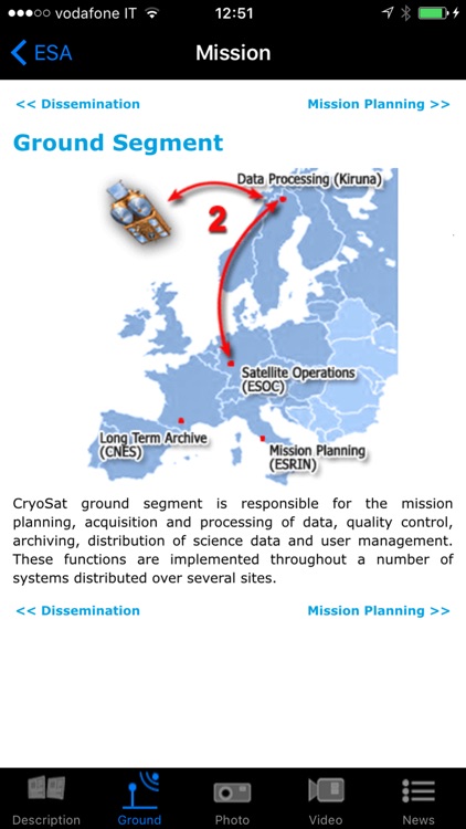
- Description of the CryoSat mission: space and ground segment
- Large selection of photos and videos on a wide range of topics related to CryoSat
- Latest mission operations news
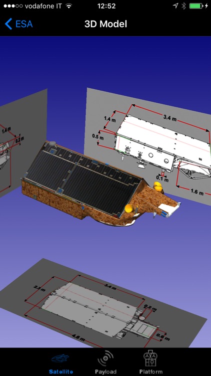
- Striking CryoSat 3D model with explanations of the different platform and payload elements
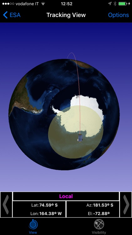
- World map with orbit position of the satellite
- Satellite visibility over selected ground stations and local position
- Automatic update of the CryoSat orbit
- Impressive visualization of real Cryosat measurements over the Earth with vertical profiles and easy geographical localization
- Access to several geophysical parameters measured by the satellite
…and much more
Continued use of GPS running in the background can dramatically decrease battery life.
In the 3D environment:
- swipe/pinch to rotate/zoom the satellite model
- triple touch to reset position
Disclaimer:
AppAdvice does not own this application and only provides images and links contained in the iTunes Search API, to help our users find the best apps to download. If you are the developer of this app and would like your information removed, please send a request to takedown@appadvice.com and your information will be removed.
AppAdvice does not own this application and only provides images and links contained in the iTunes Search API, to help our users find the best apps to download. If you are the developer of this app and would like your information removed, please send a request to takedown@appadvice.com and your information will be removed.