Take Your Hikes to the Next Level With Gaia: GPS
When you're adventuring in the great outdoors, whether going on a long-distance hike or just doing local exploration, it's important to be prepared. Part of that means having the latest and best maps available to you, even when you don't have an internet connection. Gaia GPS has been providing this for years, and the latest version aims to be better than ever.

Gaia GPS has been around for years, making wilderness exploration easier and safer than ever before. In the latest version, it's been infused with the best topographical maps available in the United States, Canada and other countries. Gaia GPS supports downloading maps for offline use, and allows you to save your tracks, way points, and maps to the cloud so you can access them from any of your iOS devices or computer. Search for trails, parks, natural features, and more from within one app.
Setting a new standard for outdoor apps
One of the Best Outdoors Mapping Apps Available

Gaia GPS has, and continues to, set the standard that other outdoors GPS apps have to live up to. It includes topo maps from the United States Geological Service, United States Forestry Service, and more. It even has its own vector-based topographic map of the entire world, and all of the maps are easy to download for use even when you have no internet connection. Allowing you to record and save tracks and way points, it's like having a standalone GPS device right in your iPhone.

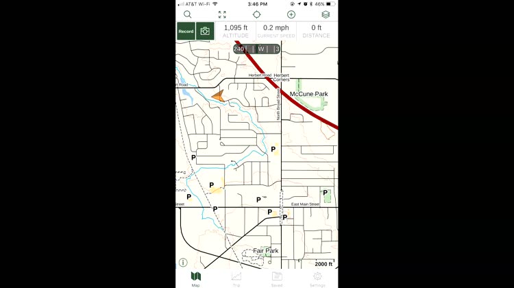
Within Gaia: GPS, you can choose your favorite map source. The app includes access to all of the USGS topographic maps, as well as terrific navigation images for Canada. You can also access Gaia's own map server, which covers the entire world. The maps will help you know where the elevation changes and other challenges might lie in wait, so you can traverse the trails in confidence. If you want a bird's eye view of the terrain, a satellite overlay is also available.

The internet isn't always available in the great outdoors, but your maps can be. With Gaia: GPS, you're able to download a map of the area you'll be hiking or exploring, so your navigation aid is available even when the internet isn't. Since Gaia uses your iPhone's built-in GPS, it keeps track of where you are as you traverse the trails.
If you prefer another option, try these on for size
If you prefer another option, try these on for size
There are definitely other apps available for mapping your hike, but Gaia: GPS is one of the most comprehensive I've found. And trust me, I've looked. The only real drawback to this app is its cost: once your seven-day free trial is over, Gaia GPS costs $9.99 per month for the Member subscription or $29.99 for a Premium plan. Considering the cost of standalone GPS handsets, which you won't need with this app, the investment is well worth it.
Gaia: GPS has a comprehensive set of features
Plan a hike with Gaia: GPS

Gaia GPS provides you with topographic maps that you can use to plan your hike. You'll know right away where the elevation changes and other challenges might await you, and can plan your route accordingly. Using Gaia GPS, you can set waypoints to direct your route, and the app will automatically plan the best directions for you to take. It knows where streets and hiking trails are throughout most of the United States and Canada, and uses them to craft a route for you to take. Of course, you can always change that and redirect your path to take a more "as the crow flies" journey, if you choose.
Choose your map source in Gaia: GPS

Within Gaia: GPS, you can choose your favorite map source. The app includes access to all of the USGS topographic maps, as well as terrific navigation images for Canada. You can also access Gaia's own map server, which covers the entire world. The maps will help you know where the elevation changes and other challenges might lie in wait, so you can traverse the trails in confidence. If you want a bird's eye view of the terrain, a satellite overlay is also available.
Save maps to your device for offline use

The internet isn't always available in the great outdoors, but your maps can be. With Gaia: GPS, you're able to download a map of the area you'll be hiking or exploring, so your navigation aid is available even when the internet isn't. Since Gaia uses your iPhone's built-in GPS, it keeps track of where you are as you traverse the trails.
Record your hike with Gaia: GPS

Planning and viewing your hike isn't the end of what Gaia: GPS can do. Tap in the top left corner to record, and Gaia starts keeping track of your path. You can later view how well you "hiked the plan," and get ideas for new places to explore later. You can also use the recorded tracks to retrace your steps, if you want to find something you missed or just want to do more sight-seeing.
Access your camera right from within Gaia: GPS

No hike would be complete without photographs. After all, "pictures or it never happened." You don't even have to leave the app to snap a picture, since Gaia: GPS has conveniently placed a shortcut to your iPhone's camera within the menus. Snap a picture, and then go back to planning your next steps. You can keep a photographic trail of your travels through the back country, so you'll be able to revisit and relive the memories later.


