You are using an outdated browser. Please
upgrade your browser to improve your experience.
Our team developed a mobile application that simply and quickly shows a drone operator local conditions before they take flight

dronership
by David Katz
What is it about?
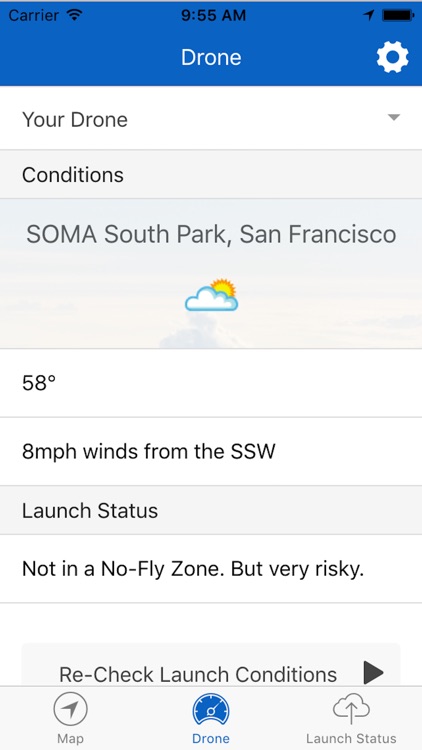
Our team developed a mobile application that simply and quickly shows a drone operator local conditions before they take flight. Realizing that drone operators want to get up in the air as fast as possible, we created a four level "risk assessment" that would quickly relay information in a clear and concise way. A background image further reinforces current conditions at a glance.
App Store Description
Our team developed a mobile application that simply and quickly shows a drone operator local conditions before they take flight. Realizing that drone operators want to get up in the air as fast as possible, we created a four level "risk assessment" that would quickly relay information in a clear and concise way. A background image further reinforces current conditions at a glance.
Though we place high value in simple and clean design for the applications, we also realized that there would be occasions where the user would want to know specifically why the risk was assessed at the displayed level. We added an option to dive deeper into the data through an accessible context menu, and enabled the user to ability to either select from popular drone types to get important information like range, min and max operating temps, and weight. This allows the user to get a more accurate picture of how their drone will perform. While a mobile/web hybrid app was the focus for the competition, the technology under the hood is useful to both ground station and onboard solutions. As drones become increasingly automated, we anticipate the ability to quickly sense changing weather conditions and asses risk will be critical to the success of future flights. RESOURCES USED Wunderground API, JavaFX desktop application, ionic hybrid app, cordova Geolocation, mapbox (deprecated), geo.json datasets, and angularJs.
ios Icon credit goes to Nico Tzogalis from theNounProject.
Disclaimer:
AppAdvice does not own this application and only provides images and links contained in the iTunes Search API, to help our users find the best apps to download. If you are the developer of this app and would like your information removed, please send a request to takedown@appadvice.com and your information will be removed.
AppAdvice does not own this application and only provides images and links contained in the iTunes Search API, to help our users find the best apps to download. If you are the developer of this app and would like your information removed, please send a request to takedown@appadvice.com and your information will be removed.