You are using an outdated browser. Please
upgrade your browser to improve your experience.
Evaluation version of MID WiFi and Marine Instrument Display

MID WiFi (Free)
by Veera Solutions Oy
MID WiFi (Free) Offers Apple Watch App
Check the details on WatchAware
Check the details on WatchAware
What is it about?
Evaluation version of MID WiFi and Marine Instrument Display.
App Screenshots
App Store Description
Evaluation version of MID WiFi and Marine Instrument Display.
Marine Instrument Display WiFi allows you to create/follow/transfer routes, track your path, control autopilot, receive/store/forward NMEA0183 data over WiFi and see AIS targets on the map. Send/receive data through iCloud (e.g. remote anchor alarm).
MID WiFi also features the world's first autopilot controller app for Apple Watch.
Search "Marine Instrument Display" for Lite version.
FEATURES
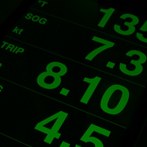
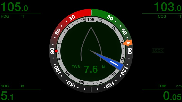
- Compass Heading (mag/true) (HDG)
- Clock (utc/local) (CLK)
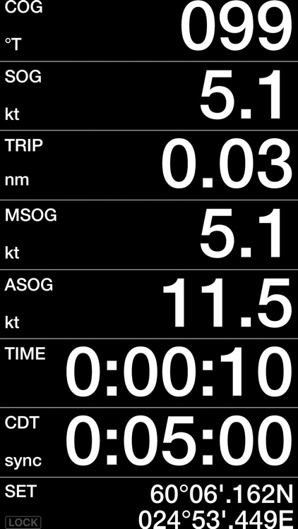
* Course Over Ground (COG)
* Speed Over Ground (SOG)
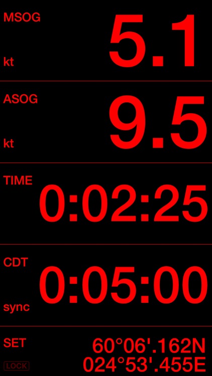
* Average SOG (ASOG)
* Maximum SOG (MSOG)
* Trip Distance (TRIP)
* Trip Time (TIME)
* Countdown Timer (CDT)
* Distance to Line (DTL)
* Time to Line (TTL)
* Barometric Pressure (BPR) (NMEA or iPhone6->)
* Bearing to Waypoint (BTW)
* Distance to Waypoint (DTW)
* Time to Waypoint (TTG)
* Cross Track Error (XTE)
* Velocity Made Good to Waypoint (VMGwpt)
* Heeling (HLG)
* Position
** Apparent Wind Angle and Speed (AWA, AWS)
** True Wind Angle and Speed (TWA, TWS)
** Maximum Apparent/True Wind Speed (MAWS, MTWS)
** True Wind Direction (TWD)
** Velocity Made Good to Wind (VMGwnd)
** Boat Speed (SPD)
** Maximum Boat Speed (MSPD)
** Depth (DPT)
** Air and Sea Temperatures (AIR, SEA)
** Predicted Boat Speed (PSPD)
** Boat Speed to Predicted Boat Speed Ratio (SPR)
** Revolutions Per Minute (Engine/Shaft) (RPM)
** Propeller Pitch (PRP)
** NoLand Eng. Analog Values (EAV1-5)
** TackTick FFP1-4
** Rate of Turn (ROT)
** Fluid Levels (TANKS)
* = Internal GPS or NMEA-WiFi bridge required
** = NMEA-WiFi bridge required (e.g. Vesper Marine XB-8000 and WatchMate Vision, Simrad GoFree WIFI-1, RS232-WiFi, Digital Yacht iAIS/WLN10, ShipModul MiniPlex-2/3Wi, PilotsTech PilotPlug, iMux, Ockam LANbridge)
WIND VIEW
- Shows Apparent and True Wind Angles simultaneously
- Size of the blue sector indicates the variation in wind direction
- Red dot shows the BTW
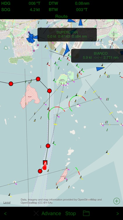
MAP VIEW
- AIS targets (**
- Create and follow routes
- Transfer routes on NMEA
- Create and replay tracks
- Autopilot control (Raymarine, requires MiniPlex-3Wi)
- Share tracks and data by email (GPX, NMEA)
- Access stored NMEA data via iTunes File Sharing
ALARMS
- Depth (Deep, Shallow)
- Anchor (Deep, Shallow, Distance)
- Wind (AWA/TWA/AWS/TWS High/Low, TWD Shift)
HOW TO USE
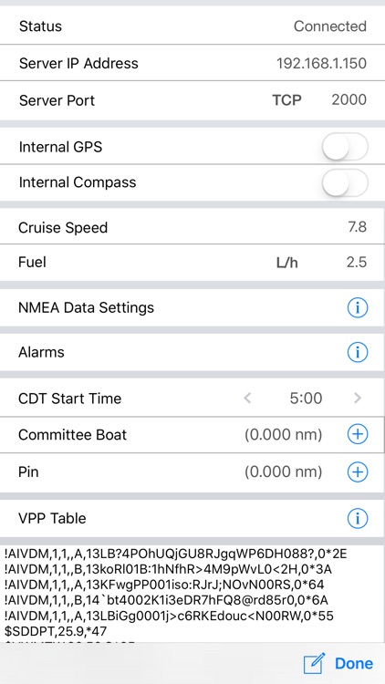
- Tap the SET to enter the Settings page
- Tap the value of any field to cycle through the color modes
- Tap/swipe the title of any field (such as TIME) to select the data to the field
- Tap a unit to cycle through the unit modes
- Tap the unit (°) of the heeling (HLG) to calibrate (zero angle)
- Press the value of any field at least two seconds to reset the TIME, ASOG, MSOG and TRIP
- Rename a route or a track by tapping the name of it
- Use IP address 255.255.255.255 for the UDP broadcast/multicast. The port for the Simrad GoFree discovery is 2050 or 2052, 5000-5010 are for Ockam LANbridge and 55554 for SailTimer Wind Vane.
- Use 127.0.0.1 and port 55554 SailTimer Wind Instrument
- NMEA0183 data can be forwarded as UDP multicast to other devices
- The trip time runs while moving (SOG > 0)
- The COG is shown while moving (SOG > 0)
COUNTDOWN TIMER
- Configure the start time (1 - 30 minutes) by touching the SET to enter the Settings view
- Start/sync the timer by touching the "sync"
- Stop the timer by touching the "sync" at least two seconds
- The timer beeps every minute and when 50, 40, 30, 20, 10, 5, 4, 3, 2, 1, 0 second(s) are remaining
CALIBRATION
1. The back cover must be faced forward accurately in order to get the correct compass heading.
2. Mount the iPhone/iPad securely and make sure it cannot move accidentally to ANY direction.
3. Tap the unit field (°) of the heeling (HLG). HLG is set to zero and the heading shows the correct value.
Continued use of GPS running in the background can dramatically decrease battery life.
Disclaimer:
AppAdvice does not own this application and only provides images and links contained in the iTunes Search API, to help our users find the best apps to download. If you are the developer of this app and would like your information removed, please send a request to takedown@appadvice.com and your information will be removed.
AppAdvice does not own this application and only provides images and links contained in the iTunes Search API, to help our users find the best apps to download. If you are the developer of this app and would like your information removed, please send a request to takedown@appadvice.com and your information will be removed.