You are using an outdated browser. Please
upgrade your browser to improve your experience.

Powerful and versatile GPS application for any recreational or professional use

PathAway Express - Outdoor GPS
by MuskokaTech Inc.


What is it about?
Powerful and versatile GPS application for any recreational or professional use. Record tracks, capture points, create and follow routes, navigate with online, cached, or custom imported maps, share location with others. The Express Edition is a fully customizable navigation and mapping solution with support for customized PathAway maps. Use the PathAway tools to create and calibrate your own layered maps. Any digitized map can be turned into a moving map navigational chart. PathAway maps can also be created or acquired from third-party sources. Visit http://pathAway.com for links to PathAway map sources.
PathAway Express is $29.99 but there are more add-ons
-
$19.99
Professional Edition Upgrade
-
$12.99
Upgrade to PRO Edition 30% off
App Screenshots


App Store Description
Powerful and versatile GPS application for any recreational or professional use. Record tracks, capture points, create and follow routes, navigate with online, cached, or custom imported maps, share location with others. The Express Edition is a fully customizable navigation and mapping solution with support for customized PathAway maps. Use the PathAway tools to create and calibrate your own layered maps. Any digitized map can be turned into a moving map navigational chart. PathAway maps can also be created or acquired from third-party sources. Visit http://pathAway.com for links to PathAway map sources.
Check out some of these 5 star reviews:
***** Best GPS App yet! - g11nMike - USA
Pathaway is the best so far. All my other topo and tracking apps will be removed now.
***** Finally! View GPS raster maps on the iPhone - world28 - France
All other programs have fallen behind now! Just super. Now, the dream tool is here!!. Bravo developers!
***** Only GPS App you will need for the backcountry - KootenyGuy - Canada
This is it...The only GPS app you will need for backcountry activities! The PathAway team have done a great job of putting the backcountry at our iPhone fingertips.
***** This is it! - Goosilein - Germany
Perfect! This is THE off-road GPS navigation program in general. There is no better and certainly not at that price. For me, the most "killer features" now implemented.
***** At last, all my maps on the iPad - Fantasiakreuzfahrt - Germany
* Read full reviews on http://pathaway.com *
PathAway's powerful feature-set makes it useful for any off-road GPS activity such as aviation, boating, off-road driving, hiking, cycling, touring, Geocaching, rally racing, motorcycle touring, running and athletic training, ballooning, fishing, hunting, paragliding, mountain climbing, ultra-light flying, canoeing, snowmobiling, scuba diving, outdoor education, mapping/GIS, mining, military training, surveying, site inspection, telematics, field data collection, search and rescue, or any application where location is important.
Features:
- Tried and tested software base developed with user feedback over the last 10 years;
Maps:
- Use online maps from OpenStreetMap, OpenCycleMap, USGS Topos;
- Maps are downloaded on-the-fly as you travel;
- Maps can be cached for off-line use when connectivity is not available;
- Import and use customized PathAway maps created using PathAway or 3rd party Tools;
Tracking:
- perform extensive GPS track logging limited only by system memory;
- Pause and continue track timer for precision timing;
- One touch "BackTrack" feature to find your way home after recording your way out;
- Manage and Edit Track logs and track points;
- Share location with others, monitor their location on the map.
Points:
- Capture points, describe by name, icon, description, photo;
- Over 100 icons to choose from;
- Manage and Edit Points;
- Organize your points by creating multiple Points Databases;
Navigation:
- Navigate using point-to-point or multi-point routes;
- Create navigational routes simply be tapping on the map to add or insert route points;
- Proximity to point and off-track Alarms;
- Auto Rotate maps to direction of travel
- Uses build-in magnetic compass for slow speed directional location. Great for Geocaching when you’re trying to pin-point a cache..
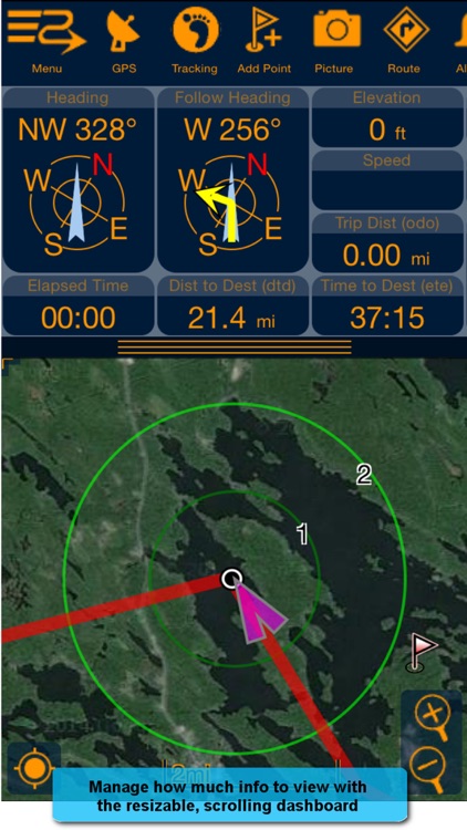
- View navigational information on a customizable dashboard;
- Map View or Compass and Info Views;
- Multiple coordinate grid and datum display including lat/long, UTM, OSGB, MGRS, MGA, GGRS87, Warschauer, Localized Grids for Austria, Germany, Quebec, Sweden, Switzerland, Israel.
- Import/Export GPX, KML, KMZ, and PathAway delimited files.
- For advanced features and location sharing, see PathAway PRO is available as stand-alone or in-app upgrades.
NOTE: Continued use of GPS running in the background can decrease battery life. Background processing can be configured in the Settings dialog.
Disclaimer:
AppAdvice does not own this application and only provides images and links contained in the iTunes Search API, to help our users find the best apps to download. If you are the developer of this app and would like your information removed, please send a request to takedown@appadvice.com and your information will be removed.
AppAdvice does not own this application and only provides images and links contained in the iTunes Search API, to help our users find the best apps to download. If you are the developer of this app and would like your information removed, please send a request to takedown@appadvice.com and your information will be removed.