You are using an outdated browser. Please
upgrade your browser to improve your experience.

• Uses custom maps, based on the free and open maps of OpenStreetMap (OSM, www

sbNavi
by SBOING

What is it about?
• Uses custom maps, based on the free and open maps of OpenStreetMap (OSM, www.openstreetmap.org).
sbNavi is FREE but there are more add-ons
-
$9.99
Upgrade to Platinum Edition
-
$4.99
Upgrade to Gold Edition
App Screenshots

App Store Description
• Uses custom maps, based on the free and open maps of OpenStreetMap (OSM, www.openstreetmap.org).
• Adaptive and self-improving, due to its collaborative and crowd-sourcing nature,
• By utilizing historical traffic data, it leads to more accurate routing decisions, compared to existing commercial PNAs,
which are based on static traffic information (i.e. the speed limit of each road),
• Distinguishes and provides better time estimates, depending on the type of vehicle (e.g., pedestrian, fast / slow
motorcycle, fast / slow car, truck, bus, taxi), weather and corresponding road conditions (sun, rain, snow, etc.), time-of-day,
day-of-the-week, holiday and season-of-year,
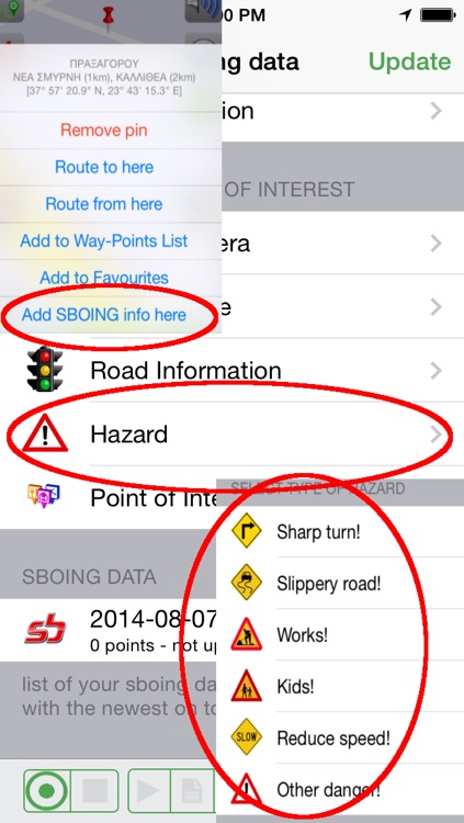
• It has an inherent, independent mechanism: a) to produce new maps (for uncharted areas), and b) to self-update existing maps
(crowd sourcing support by entering user input about road hazards, police blocks, traffic lights, traffic signs, POIs, favorites,
road network changes, etc.)
• High usability with most of its functionality achieved with 1-2 user clicks
• Multiple, user-defined views using user-defined macros (a unique feature)
• High user-configurability (configuration menu, map style/colors, POI layers, favorites categories, vehicle choice, day/night
mode, etc.)
• Route simulation mode
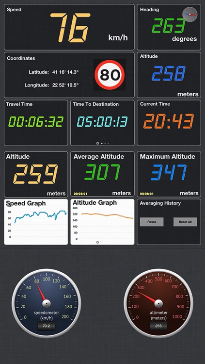
• Dashboard with two digital screens and one with analog gauges
• 2D and 3D map viewing with pan, zoom, and rotate functionality, with continuous varying 3D viewing angle (tilt)
• "Lock on driver's view" functionality
• User routes can be recorded and recorded routes can be managed, securely up-loaded to SBOING, sent by email and replayed (on
the smartphone, on a PC, or via Google Earth)
• Searching: a) by free text search, b) in Favorites, c) in POIs, d) by coordinates, e) by proximity
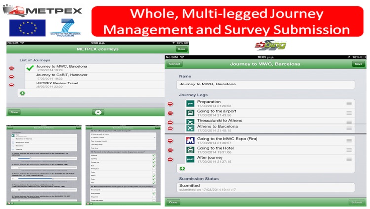
• Easy definition of multi-waypoint lists
• Multi-waypoint (multi-legged) routing
• Multi-lingual support for text and voice guidance
• Able to accommodate the maps of the entire planet in a single memory card
• Adaptive and compatible with a plethora of PNAs and smartphones,
• Uses strong security (strong encryption) in all data uploads carried out by the user, thus ensuring the confidentiality of
its private information.
• In-app version upgrades and support for promotion upgrades.
Disclaimer: Continued use of GPS running in the background can dramatically decrease battery life.
Disclaimer:
AppAdvice does not own this application and only provides images and links contained in the iTunes Search API, to help our users find the best apps to download. If you are the developer of this app and would like your information removed, please send a request to takedown@appadvice.com and your information will be removed.
AppAdvice does not own this application and only provides images and links contained in the iTunes Search API, to help our users find the best apps to download. If you are the developer of this app and would like your information removed, please send a request to takedown@appadvice.com and your information will be removed.