You are using an outdated browser. Please upgrade your browser to improve your experience.

Get Maps for All Your Activities With These Apps

Find your perfect hiking trail, bike route, or run. These maps let you explore new and exciting trails for your next outdoor adventure.

AllTrails: Hike, Bike & Run
komoot - hike, bike & run
TrailLink: Bike, Run, Walk
bergfex: Hiking & Tracking
Maps 3D PRO - Hike & Bike

Best Apps

Highest scored apps in the category

Get the information you need
AllTrails: Hike, Bike & Run

AllTrails

AllTrails, Inc.

Explore hiking trails near your location with photos, reviews, directions, and details.

AllTrails Hiking & Mountain Biking Trails is an intuitive app with all the details you need for your next hike. Search nearby, see photos, get full trail details, check out the map, read reviews, check in, and get directions.

komoot - hike, bike & run

komoot

komoot GmbH

Turn your next ride, hike, or run into an adventure with komoot

Turn your next ride, hike, or run into an adventure with komoot. Get inspired by tapping into shared community knowledge and recommendations, then bring your adventures to life with the easy route planner.

PLAN YOUR PERFECT HIKING, MOUNTAIN BIKING OR ROAD CYCLING ADVENTURE
Get the route perfect for your sport—be it smooth asphalt for your road bike, singletracks for your mountain bike,...

Also Good

Apps with average score

TrailLink: Bike, Run, Walk

TrailLink: Bike, Run, Walk

Rails-to-Trails Conservancy

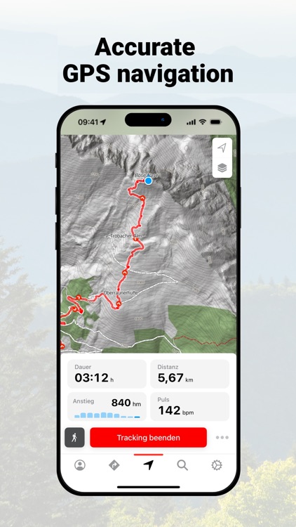
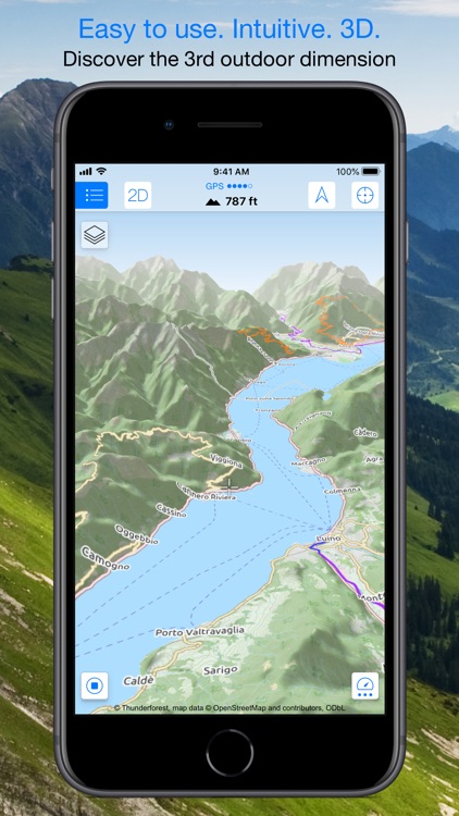
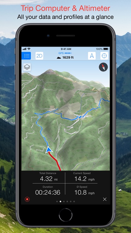
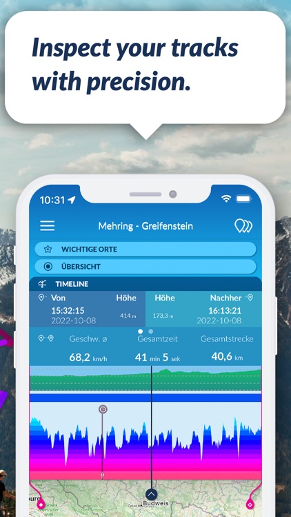
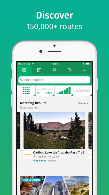
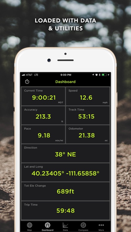
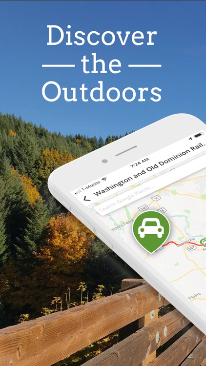
TrailLink is the ultimate trail-finder app to help you stay active and get outdoors. Enjoy full-length trail descriptions, reviews, photos, and detailed trail maps not found anywhere else!

Discover amazing trails near you that are perfect for cycling, jogging, walking, workouts and more. Explore over 40,000 miles of multi-use trails in...

bergfex: Hiking & Tracking

bergfex: Hiking & Tracking

bergfex GmbH

The bergfex: hiking & tracking app is a must-have for every hike, ski tour or other outdoor activity.

Find the most beautiful hiking trails in your area or create personal tours with our route planner and track all your outdoor activities. Precise GPS navigation, detailed hiking maps for the entire Alpine...

Maps 3D PRO - Hike & Bike

Maps 3D PRO - Hike & Bike

movingworld GmbH

Enjoy exploring the great outdoors? If you’re a fan of biking, hiking and running then Maps 3D is the ideal app designed for planning your outdoor adventures. Whereas other mapping apps are primarily designed for cities and roads, displaying hills and mountains as flat and lifeless features, Maps 3D is...

Maps 3D - Hike & Bike

Maps 3D - Hike & Bike

movingworld GmbH

Enjoy exploring the great outdoors? If you’re a fan of biking, hiking and running then Maps 3D is the ideal app designed for planning your outdoor adventures. Whereas other mapping apps are primarily designed for cities and roads, displaying hills and mountains as flat and lifeless features, Maps 3D is...

Footpath Route Planner

Footpath Route Planner

Half Mile Labs LLC

Map routes with your finger and Footpath will snap to roads and trails. Measure distances and elevations in seconds, then navigate along with turn-by-turn directions.

Footpath is the ultimate companion for planning and navigating custom routes.

Join millions of adventurers and plan out your perfect route.


SNAP TO MAP
Quickly measure distances...

TraceMyTrack
TraceMyTrack
TraceMyTrack

TraceMyTrack

Corandus GmbH

Here comes TraceMyTrack LITE: The free app that allows you to easily track your trips, tours or sports activities!

Whether on foot or by bike, on the road or in the air: With TraceMyTrack LITE you can record tracks with a length of up to about 50 km and...

TraceMyTrack PRO
TraceMyTrack PRO
TraceMyTrack PRO

TraceMyTrack PRO

Corandus GmbH

Discover TraceMyTrack PRO: Your personal travel diary for every journey, tour, or sporting activity! With this app, you effortlessly record every move and maintain complete oversight of all the details of your adventure. Data protection is our top priority - your data stays safe on your device. Get started immediately,...

TrailSmart: Great Trails

TrailSmart: Great Trails

Eugene Mallay

TrailSmart: Great Trails of the World is a comprehensive, incredibly handy mobile app providing in-depth coverage of some of our favourite long-distance trails. Use it on its own or as a complement to a printed guidebook. Once downloaded, no Internet connection is required.

*** TrailSmart is fully-functional with all trail content...

ViewRanger: Hike, Bike or Walk

ViewRanger: Hike, Bike or Walk

Augmentra

ViewRanger has a lot of potential but requires the community to add more content to the app. The interface is very complicated and though this app could potentially be very useful, it fails to meet expectations. ViewRanger uses OpenMaps and other community-generated mapping resources to function and allows users to...

Trails · Outdoor GPS Logbook

Trails · Outdoor GPS Logbook

iosphere GmbH

Record all your outdoor activities be it hiking, jogging, cycling, or canoeing, and observe real-time statistics on your Apple Watch.

Trails records and displays your geo coordinates along with comprehensive statistics including duration, distance, altitude, ascent/descent, speed, pace, step count (iPhone 5S and newer), and many more. Capture photos, mark waypoints...

GPS Kit - Offline GPS Tracker

GPS Kit - Offline GPS Tracker

Garafa, LLC

GPS Kit is unlike the other apps in the sense that it is for the serious outdoorsman/woman. It was designed for hiking, hunting, camping, skiing, mountain biking, and even fishing. It is perhaps not the ideal app for runners due to the features that are better suited to an adventure...

MeeRun Sports Tracker

MeeRun Sports Tracker

Benoit Walter

MeeRun is a GPS Sports Tracking application which provides a user-friendly and
powerful way to monitor and review your sport activities.

SIMPLE. POWERFUL. ACCURATE.
- Accurate tracking
- GPS, motion sensor (pedometer), altimeter, heart rate monitor, ...
- Light-weight and intuitive UI
- For all your activities: running, cycling, hiking, skiing, skating and more

100% PRIVACY,...

Other Apps

Could be good for special cases

GeoFlyer Europe 3D Maps Lite

GeoFlyer Europe 3D Maps Lite

GeoMind

How would you like a mapping app with routing and GPS tracking that offers you the BEST 3D VISUALIZATION for the outdoors?

How would you like a mapping app that shows points of interest in 3D with info or links to embedded Wikipedia pages?

How would you like a mapping app that works OFFLINE (*), too?

GeoFlyer 3D Maps offers you all this and more... And now you can try the LITE version for free!

If you love hiking, biking, horseback riding, or any other outdoor activity, GeoFlyer 3D Maps is the app you need.

MAIN FEATURES
- Online and Offline (*) modes (with preloading of selected areas)
- Highly-detailed 3D terrain
- 3D labels/icons of Points of Interest (POIs)
- Integrated Wikipedia descriptions
- Place searching by name (Online and Offline)
- GPS tracking
- Routing
- Sync of tracks and routes on all your devices (iCloud)
- Altimetry graph and statistics
- Custom-made gCARTA topographic chart
- Gyroscope features: GyroPilot and First Person View (Immersive Reality)
- what3words coordinate-mapping system.

GeoFlyer 3D Maps Europe reproduces the terrain in 3D with stunning details, using the best available digital elevation models from NASA and various European mapping agencies.

The terrain is overlaid with a custom-made topographic chart (gCARTA) that shows trails and accurate elevation contour lines, or aerial images if you prefer.

Find out more about a POI using the labels and icons. Wikipedia geo-tagged entries and other associated content are integrated right into the 3D map.

Plan your trip using multiple routing options, and save your routes for later use.

Record your GPS tracks and share (*) them with your friends through Facebook or other social media.

Get the best from your outdoor experience with the “First Person View” mode, a sort of augmented reality feature that enables you to see a virtual 3D view of what is in front of you, allowing you to identify peaks and other landmarks.

And it’s fun! Try the GyroPilot mode: dive into the valleys with a low level flyby, handling your device like a virtual plane, and explore the maps like a top-gun pilot!

GeoFlyer 3D Maps… your outdoor companion!


UPGRADE FROM LITE TO FULL VERSION:
If iCloud is enabled, in the Full version you will keep your existing tracks and routes.

(*) REDUCED FUNCTIONALITIES IN THE LITE VERSION:
- Offline mode not available
- Limited number of recorded tracks and routes
- Sharing of tracks and routes not available


WARNING
Continued use of GPS running in the background can dramatically decrease battery life.

GeoFlyer US Canada 3D Maps

GeoFlyer US Canada 3D Maps

GeoMind

How would you like a mapping app with routing and GPS tracking that offers you the BEST 3D VISUALIZATION for the outdoors?

How would you like a mapping app that shows points of interest in 3D with info or links to embedded Wikipedia pages?

How would you like a mapping app that works OFFLINE, too?

GeoFlyer 3D Map offers you all this and more!

If you love hiking, biking, horseback riding, or any other outdoor activity, GeoFlyer 3D Map is the app you need.

MAIN FEATURES
- Online and Offline modes (with preloading of selected areas)
- Highly-detailed 3D terrain
- 3D labels/icons of Points of Interest (POIs)
- Integrated Wikipedia descriptions
- Place searching by name (Online and Offline)
- GPS tracking
- Routing
- Sync of tracks and routes on all your devices (iCloud)
- Altimetry graph and statistics
- Custom-made gCARTA topographic chart
- Gyroscope features: GyroPilot and First Person View

GeoFlyer 3D Map reproduces the terrain in 3D with stunning details, using the best available digital elevation models from the US Geological Survey and NASA.

The terrain is overlaid with a custom-made topographic chart (gCARTA) that shows trails and accurate elevation contour lines, or aerial images if you prefer.

Find out more about a POI using the labels and icons. Wikipedia geo-tagged entries and other associated content are integrated right into the 3D map.

Plan your trip using multiple routing options, and save your routes for later use.

Record your GPS tracks and share them with your friends through Facebook or other social media.

Get the best from your outdoor experience with the “First Person View” mode, a sort of augmented reality feature that enables you to see a virtual 3D view of what is in front of you, allowing you to identify peaks and other landmarks.

And it’s fun! Try the GyroPilot mode: dive into the valleys with a low level flyby, handling your device like a virtual plane, and explore the maps like a top-gun pilot!

GeoFlyer 3D Map… your outdoor companion!

Map coverage: continental US, Canada and northern Mexico (min latitude: 23°, max latitude: 59°).

WARNING
Continued use of GPS running in the background can dramatically decrease battery life.

Lincoln Park (Chicago) - GPS Map Navigator

Lincoln Park (Chicago) - GPS Map Navigator

Flytomap

Lincoln Park map is extremely advanced with all information collected from the National/State Park and Forest Services and many other local sources. The maps contain all trails (Hiking, Biking, Equestrian trails etc.,) and Points of interests (POI) like Campgrounds, Visitor Centers, Lookout points, Eating places, Ranger Stations, Picnic areas, Boat/Canoe ramps, Parking areas etc. and much more

“Offline maps with satellite modes won’t let you go below your expectations anywhere during voyage”


•Fast Zoom and Pan
•Add as many as Favorites
•Find locations by Lat Lon
•Compass
•Advanced Photo Management
•Multiple Waypoints can be inserted
•Accurate GPS
•Save Track and email friends
•User & Park Guide
•Search your Favorite points or any location by name

“Guide lists number of activities and facilities info. for Picnics and Barbecues, Cycling, Fishing, Walking Tracks, Paddling etc.

“Exploring the map you will find all Trails, Point of Interests (POI), Lakes, Rivers, Elevations etc and many more…….”

Note:

"Continued use of GPS running in the background can dramatically decrease battery life."

"Turn off GPS when not in use"

ViewRanger 2018

ViewRanger 2018

Augmentra

ViewRanger is now part of Outdooractive.

We recommend new users to download the new Outdooractive app instead of ViewRanger.
Search for "Outdooractive" and download the app for free.

If you are already using ViewRanger, we offer you an easy way to move to Outdooractive.

APPLE HEALTH
- By accessing your Apple Health data, ViewRanger can give you even more detailed information about your activity, including the number of steps you’ve walked and your heart rate (when using Apple Watch™ or Bluetooth 4.0 enabled devices).
- Tracks recorded from your walks, cycle rides and other activities in ViewRanger can be saved to Apple Health as workouts.
-------------------------------
In-App Subscriptions
We offer a range of auto-renewing subscriptions, including:
Premium, Premium + Ordnance Survey Maps for Great Britain, Premium + IGN Maps for France & Premium + USA Maps.
Prices may vary per country. Prices are clearly displayed in the app.
Subscribe, pay, and manage subscriptions in your iTunes account. Subscriptions automatically renew unless canceled at least 24 hours before the end of the current period. Refunds not provided for any unused portion of subscription. Your account will be charged for renewal within 24-hours prior to the end of the current period at the subscription price option you have previously selected.

Terms of use: my.viewranger.com/page/terms
Privacy policy: my.viewranger.com/page/terms#privacy
-------------------------------

Any questions or feedback, please drop us an email: support@viewranger.com

Continued use of GPS running in the background can dramatically decrease battery life.