You are using an outdated browser. Please upgrade your browser to improve your experience.

Apps for Mountain Bikers and Outdoor Cyclers

For riders looking to explore new outdoor routes these apps are your perfect companion. Track your rides and trails and share with friends!

Trailforks: Offline Bike Maps
Mammoth Mountain
MTB Project
EasyTrails GPS
Bike Tracks
Trailforks: Offline Bike Maps

Trailforks: Offline Bike Maps

Pinkbike.com

Trailforks is a trail database & map with over 650,000 trails. Users can contribute data and then local trail associations have the control to approve & curate the data.

Get 14 days of free app use, then upgrade to Trailforks Pro to unlock the map world-wide. Otherwise continue to use the map in your local area for free.

App Features:
- The largest database of mountain bike trails in the world, including thousands of biking related POI's
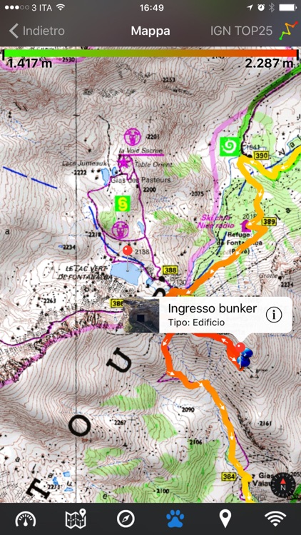
- Offline trail maps and info. Region updates are incremental and fast
- See your GPS location on the map, for trail navigation
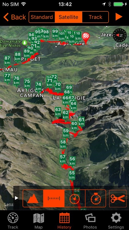
- Record your GPS location during ride creating a track
- Display trail & route elevation profiles and 'scrub' along them to see the location on the map
- View local routes that users have created
- View trail logs from users and discover how to explore a new trail
- Automatic trail routing from your location (or nearest parking lot), to the trailhead of your choosing
- Sync and view your saved plans from the Trailforks website
- Follow race course routes including colored stages and checkpoints
- Lookup region & trail info including routes, photos, videos & more
- Use your phone’s compass to orientate the map in the direction you’re facing
- View trail status & reports! Always be informed of up-to-date trail conditions & closures
- Submit trail reports & conditions from the app, including taking photos of trail issues
- Support the areas you ride, by donating 'Trail Karma'
- View nearby bike shops on the map, quick links for directions or phoning the shop
- View trails on map color coded by popularity
- Mountain biking heatmap!
- View custom worldwide topo maps designed for outdoor trail activities

The Trailforks app is your mobile companion to the Trailforks website. It allows you to download offline trail maps for use on your rides!

Terms of Use: https://www.trailforks.com/about/tou/?source=tfapp&app=1 and https://www.apple.com/legal/internet-services/itunes/dev/stdeula/
Note: Continued use of GPS running in the background can dramatically decrease battery life.

Mammoth Mountain

Mammoth Mountain

Alterra Mountain Company

The official Mammoth Mountain application to make your next mountain experience the best mountain experience.

Features a GPS enabled, highly visual trail map. Find your location and see where your friends are. Check the live weather conditions, daily resort video reports, live webcams, and lift reports. Stay up to date on all the resort conditions. Check in’s, live social interaction, and friend finder can keep your snow experience fun and exciting. Easily access all of the mountains deals and be the first to find out about upcoming events. Complete mountain specific challenges around locations, vertical, distance and speed!

** Interactive GPS Trail Map **
GPS location enabled
See friend’s locations right on the trail map
See trail and grooming information
View images and videos taken around the resort

** Check In **
Check in when you’re are at mountain
Track the number of days you ride

** Find Friends **
View friends that are also at the hill right on the trail map

** Deals and Events **
Resort deals and coupons
View upcoming events at the mountain

** Webcams and Videos **
View live resort webcams
Watch videos taken at the resort

** Social Interaction **
Social wall shows what everyone is saying
Use Facebook or Twitter to post your own messages

** Daily Video Report **
Watch the daily snow report

** Live Weather **
Quickly get the current conditions
View the 5 day forecast

** In-depth Snow Reports **
Get the current mountain conditions

** Trail and Lift Reporting **
Get trial, terrain park, and lift status

**Challenges**
Complete all sorts of fun challenges around your

This app uses HealthKit and location services for tracking and replaying your runs on the trail map. Continued use of GPS running in the background can decrease battery life.

MTB Project

MTB Project

Adventure Projects Inc.

MTB Project is your comprehensive mountain biking guide to the trails you want to ride - with offline maps, full GPS route info, elevation profiles, interactive features, photos, and more.

Like a guidebook, we suggest the best featured rides to explore—either near your current location or in an area you search for. Local experts show you the highlights, challenging features, and insights you need to plan a great ride.

• Find more than 77,000 miles of trail to shred with your crew.
• New rides and trails are constantly added to our incredibly detailed mountain bike trail and ride database.
• Your exact location is shown on the trail.
• Downloaded trails work offline for when you’re off the grid. (No cell reception required!)
• Enjoy high-resolution photos and detailed topographical trail maps.
• We’ll sync with your to-do list and check ins on MTBProject.com.

By using GPS, we can show your location on trails and vertical profiles. Continued use of GPS running in the background can dramatically decrease battery life.

EasyTrails GPS

EasyTrails GPS

Zirak s.r.l.

EasyTrails GPS is the GPS tracker application for your iPhone.
The perfect application for those who are passionate about OUTDOOR ACTIVITIES and TRAVELING, everybody who likes outdoor sports, and not only.

Are you going for a bike or motorcycle ride? Well, EasyTrails GPS will tell you how many miles you traveled, how much time you spent, how high you climbed and many other details. In real-time it will show you the course on a map, comparing it with downloaded tracks and points of interest.

You can import or share all tracks and waypoints, photos and ideas for new journeys with your friends.

Share where you are on Facebook and Twitter through your GPS position, and export your tracks in standard formats, so you can review them on Google Earth, SportTracks and TrailsRunner. Or simply upload them to online services like Garmin Connect, or many others.

It's possible to import tracks by e-mail or Safari (EasyTrails can handle GPX, KML/KMZ and ZIP file formats), or by wi-fi networks, using an improved and easy to use web-based sharing feature.

Calculate routes and let EasyTrails guide you using the new navigation capabilities. You can also let it guide you through previously recorded tracks.
Additionally, EasyTrails GPS can communicate with navigators like Maps, Google Maps, TomTom or Waze (if installed) for more advanced guidance needs.

Load custom cartography, EasyTrails supports KMZ and MBTILES formats.

EasyTrails GPS is easy to use and extremaly accurate. It ensures the maximum duration of battery thanks to the possibility of recording in "StandBy" mode. However, be aware that use of GPS, even in background, will have a significant impact on battery duration.

► For more info, visit our website: www.easytrailsgps.com


NEW FEATURES:

► Heart rate monitoring (paid)

We added the ability to connect to compatible Bluetooth heart rate monitors (such as Polar H6 and H7 devices). Heart rate can be seen in real time from the dashboard.

With the 'Heart rate monitoring' in-app purchase:
- heart rate data will be associated to GPS tracks
- saved tracks will have an extra heart rate chart
- heart rate data will be saved to HealthKit

Additionally, with the 'Colored tracks' in-app purchase, it will be possible to highlight heart rate data directly on the map screen of a recorded track.

OTHER FEATURES:

- Support for many different map types
- Support for different coordinate systems
- Support for user-loaded offline cartography (KMZ and MBTILES)
- Export tracks (single or multiple) in standard formats (GPX, KML/KMZ and CSV), with their associated waypoints and pictures
- Import tracks (GPX and KML/KMZ)
- Import waypoints (GPX and KML/KMZ)
- Resume recording of tracks
- Save waypoints with photos and descriptions
- Navigate to a point of interest
- Sharing via Facebook and Twitter
- Follow a path/track
- Navigate (distance / direction) towards any waypoint
- Navigate (distance / direction) towards any track marker (start / pause / resume / end points)
- Advanced Navigation to a waypoint using any navigation app you may have installed
- Upload tracks to GPSies (http://www.gpsies.com)
- Upload tracks to SportTracks (http://sporttracks.mobi)
- Upload tracks to OpenTrail (http://www.opentrail.us)
- Upload tracks to OkMap (http://www.okmap.org)
- Real-time visualization of distance, speed, altitude bearing and other data
- Map Visualization in different modes: street map, satellite, hybrid, terrain
- Charts (elevation profiles, ...)
- Digital Compass
- Heart rate monitoring
- Turn by turn directions
- High battery duration (record in standby)
- Select between metric, imperial and nautical measuring systems
- Intuitive and User Friendly interface
- Lightweight, reliable and accurate
- Doesn't require internet connection

Terms of Use: https://www.apple.com/legal/internet-services/itunes/dev/stdeula/
Privacy Policy: http://www.easytrailsgps.com/wp-content/uploads/2016/05/EasyTrails-GPS-Privacy-Policy.pdf

Big Bear Mountain Resort

Big Bear Mountain Resort

Alterra Mountain Company

Get in on the alpine good times with the Big Bear Mountain Resort app. Book in advance, access reservation info and interactive trail maps, or navigate the Snow Valley, Snow Summit, and Bear Mountain and Snow Summit base areas. Featuring live webcams, current lift and trail status, weather conditions, season stats, and more.

This app uses HealthKit and location services for tracking and replaying your runs on the trail map. Continued use of GPS running in the background can decrease battery life.

Map My Tracks: cycling tracker

Map My Tracks: cycling tracker

Tinderhouse

Cycling, mountain biking or just when out on the move... you can track it all, and stream it live, with Map My Tracks. Join over a million other people who use Map My Tracks to track their cycling, running and walking workouts.

Map My Tracks turns your iPhone into a high performance all-sport GPS tracker that's amazingly easy, fun and motivating to use on bike rides, runs or hikes as well as other outdoor pursuits.

=====
Featured in Apple's What's hot list
#1 iPhone app in Health & Fitness in Japan, France, Belgium, Iceland, Czech Republic
=====

It's the only app you'll need to track all your outdoor activities.

>> TRACK YOUR OUTDOOR PURSUITS
• Measure your performance across sports like running, cycling, walking, or just about any outdoor pursuit
• Track your distance, speed, pace, heart rate, calories burned, duration, elevation gain/loss
• Get a breakdown of your activities for each day, week, month or year

>>ANALYSE YOUR PERFORMANCE
• Sync activities to MapMyTracks.com for detailed analysis of your performance
• Compare your performance on segment leaderboards

>> STREAM LIVE ONLINE
• Broadcast your cycle rides, runs, and other sporting activities live for friends & family to follow online
• Post photos live to your profile during your workout

>> CHALLENGE YOURSELF
• Set goals and keep yourself motivated
• Compare and compete against others in the weekly and monthly leaderboards

>> BE SOCIAL
• Tell the whole story and add photos to your activities
• Create beautifully crafted videos of your activities to share
• Follow friends and help keep them motivated
• Share activities on Facebook & Twitter

>> DISCOVER - WITH AUGMENTED REALITY
• Identify nearby peaks, places and others tracking live with the iPhone's camera
• Browse the maps to follow people live or see others nearby
• Find new nearby routes try out
• Challenge yourself and take on local segments on your cycle rides and runs

>> CONNECT TO SENSORS AND DISPLAYS
• Connect to Bluetooth & ANT+ sensors from Wahoo Fitness (requires in-app purchase)

>> UPGRADE TO PLUS
• Unlock the full power of the app and website with a PLUS subscription
• Track live so others can follow your progress online
• Get an ad free experience
• PLUS features are available with an in-app purchase.

Subscriptions for Map My Tracks PLUS are $2.99 per month or $28.99 for a full year. Map My Tracks PLUS subscriptions will be charged to your iTunes account after your confirmation of purchase. Your monthly subscription will automatically renew each month and be charged through your iTunes account, yearly subscriptions will automatically renew each year. Subscriptions renew at $2.99 per month or $28.99 for a full year automatically unless cancelled at least 24 hours prior to the end of the current period. You can turn off auto-renew at any time from your iTunes account settings. Cancellation of the current active subscription period is not allowed.

FEEDBACK
If you're enjoying Map My Tracks leave us a good review in the App Store. If not, send your feedback to support@mapmytracks.com and let us fix it before you write a review.

Map My Tracks uses HealthKit to export your Map My Tracks activities into the Health app and to read heart rate and biometric data. This service is optional.

Please note that continued use of GPS running in the background can dramatically decrease battery life.

Terms of service: https://www.mapmytracks.com/term-service
Privacy policy: https://www.mapmytracks.com/privacy-policy

Runtastic Mountain Bike GPS

Runtastic Mountain Bike GPS

runtastic

The Runtastic Mountain Bike app turns your iPhone into a multifunctional GPS cycling computer! Whether you’re on your favorite trails or exploring new routes while enjoying the mountain scenery, Runtastic Mountain Bike is your perfect companion. Track your rides, tours and trails with your iPhone, monitor your training progress and compare your performance with your friends’! Become a part of the Runtastic Community with millions of users today.

APP FEATURES & BENEFITS: (limited in Lite version)
- Track MTB tours via GPS: Duration, distance, elevation gain, pace, calories burned, etc.
- Voice Coach: Keeps you posted on speed, distance, elevation gain, etc.
- LIVE Tracking: Track your trails in real time & show friends your current location
- Browse & search thousands of mountain bike routes (available in the app & on Runtastic.com)
- Colored Traces (speed, elevation, climb rate, heart rate, etc.)
- Configure maps: Apple Maps, Open Cycle Map, Open Street Map
- Offline maps: Download & save maps to your iPhone to use them without internet connection
- Split Tables: Analysis of each split of your mountain bike trek
- Auto Pause: No need to manually stop & start activities during short breaks (with Runtastic Speed & Cadence Sensor)
- Display your current rate of climb during a tour (elevation gain/minute)
- Show current grade in %
- Detailed post-tour analysis incl. time rode uphill, downhill, flat
- Music: Create a playlist for your tours & activate your Powersong to boost motivation!
- Cadence measurement (with Runtastic Speed & Cadence Sensor)
- Heart rate measurement (with additional hardware)
- Configure your display: You choose which values (distance, speed, elevation gain, calories burned, etc.) are shown during your rides
- Provides info on wind & weather conditions
- Save your MTB activities on Runtastic.com
- Share your mountain bike activities on Facebook, Twitter and via email

Whether you’re a beginner or a professional bike athlete, this app has everything a MTB rider could wish for!

Note: Continued use of GPS running in the background can dramatically decrease battery life.

Runtastic Terms & Conditions: https://www.runtastic.com/in-app/iphone/appstore/terms
Runtastic Privacy Policy: http://www.runtastic.com/in-app/iphone/appstore/privacy-policy

Colorado Rocky Mountain Bicycle Boys

Colorado Rocky Mountain Bicycle Boys

Spartacus, LLC

This App provides an iPhone-friendly, offline-capable view of mountain biking related events, locations, trails, and photos captured on the Colorado Rocky Mountain Bicycle Boys (RMBB) website (www.rmbb.org).

The Rocky Mountain Bicycle Boys is a casual club for mountain bikers who love the thrill and camaraderie that comes from off- road riding with friends. We especially enjoy exploring the endless miles of spectacular, scenic trails of Colorado's unique geography and history.