You are using an outdated browser. Please
upgrade your browser to improve your experience.

in top
10
of its
category
10
of its
category
This app is the ultimate mastermind of public transit systems

Transit • Subway & Bus Times
by Transit App, Inc.

FREE in the App Store
Know when the next bus is coming, which subway to take to get to work, or which public transit route will get you there fastest. The Transit App will help you get where you're going in the most efficient way possible.

Transit • Subway & Bus Times Offers Apple Watch App
Check the details on WatchAware
Check the details on WatchAware
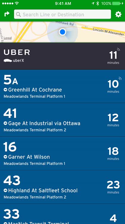
Find stops near you. You can also set lines as favorites and see the location of the next bus, for example, in real time. Setting lines as favorites makes for quicker access next time you need it (as well as not having to be nearby to see it), and you can even get data like how long an Uber ride would be in comparison to the train or bus. Convenient, huh?

Plan your route. Not sure how to use public transit lines surrounding you to get where you need to go? Plan ahead to learn about available routes and optimize your trip. Transit has a gorgeous interface that makes it easy to find nearby public transportation, and you can even plan out your trip in advance to save yourself the headache.
What is it about?
Public transit can be annoying. Sometimes you're in an unfamiliar area and aren't sure about the routes available. Or maybe you're waiting for your regular bus, only to have it not show up, and are wondering whether it's just a bit late or if you'll have to wait for the next one. Transit has you covered. The app can show you all of the available public transit lines near your location and tell you when the next vehicles are expected to arrive. And if your transit line of interest supports it, you can see the real-time location of whatever mode of transportation is on its way toward you next!
For those who...
- Use public transit regularly
- Live in a city where public transit is available (you never know when you might need to take it!)
- Want to discover their city
Not for those who...
- Never plan on ever encountering public transit
- Prefer to drive
- Prefer to use rideshare services over public transit
Why we love it
We've found that this is the most comprehensive app for becoming aware of public transit lines surrounding you in supported cities (and a lot of cities are supported!).
App Screenshots

Transit • Subway & Bus Times supports Siri commands
Instant
ETA
Instant ETA
App Store Description
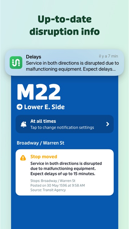
Transit is your real-time urban travel companion. Open the app to instantly see accurate next departure times, track buses and trains near you on the map, and see upcoming transit schedules. Use the trip planner to quickly compare trips - including options like bus and bike, or metro and subway. Get alerted about service disruptions and delays for your favorite lines, and save frequently used locations for trip directions in a tap.
HERE’S WHAT THEY’RE SAYING
"Gives you the best route to where you want to go" - New York Times
“You won't realize how much time you can save planning until you use this app” - LA Times
“Killer app” - Wall Street Journal
"MBTA has a favorite transit app — and it's called Transit" - Boston Globe
“A one-stop-shop” - Washington Post
AND HERE’S THE WORD FROM PUBLIC TRANSIT RIDERS
“Your app was the deciding factor in selling my car.”
“Blows Google Maps out of the water.”
“The head of our local transit agency recommended this app over the one her agency created.”
6 GREAT THINGS ABOUT TRANSIT:
1) THE BEST REAL-TIME DATA
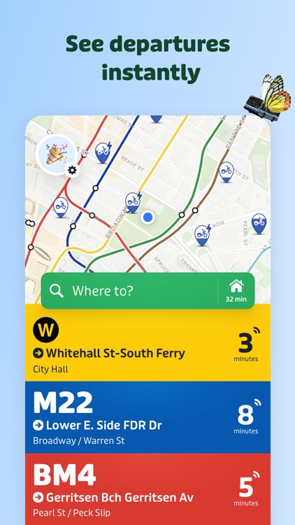
The app uses the best transit agency data sources like MTA Bus Time, MTA Train Time, NJ Transit MyBus, SF MUNI Next Bus, CTA Bus Tracker, WMATA Next Arrivals, SEPTA Real-Time and many more. We combine that data with our fancy ETA prediction engine so that you get the most accurate real-time info possible for all transit modes - including buses, subways, trains, streetcars, metros, ferries, ridehail and more. Prefer to travel on two wheels? With GPS, you can see live bikeshare and scooter locations right on the map.
2) TRAVEL OFFLINE
Bus schedules, stop locations, subway maps and even our trip planner are available offline.
3) POWERFUL TRIP PLANNING
See fast and easy trips combining buses, subways and trains – the app even suggests routes that combine multiple options in one trip like bus + bike or scooter + metro. You’ll find great trip plans that you never even considered! Don’t like to walk a lot or use a certain mode or transit agency? Personalize your travel in the settings.
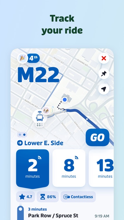
4) GO: OUR STEP-BY-STEP NAVIGATOR*
Receive departure alarms to catch your bus or train, and get alerted when it’s time to get off or transfer. When using GO, you’ll also crowdsource more accurate info and real-time ETAs for other passengers– and rack up points and thank yous for being the most helpful rider on your line.
5) USER REPORTS
See what other riders have to say! With millions of users contributing, you’ll get helpful info on crowding levels, on-time performance, the closest subway exits, and more.
6) EASY PAYMENTS
Pay your transit fare and buy bikeshare passes directly in the app in over 75 cities.
*continued use of GPS running in the background can decrease battery life.
300+ CITIES INCLUDING:
Atlanta, Austin, Baltimore, Boston, Buffalo, Charlotte, Chicago, Cincinnati, Cleveland, Columbus, Dallas, Denver, Detroit, Hartford, Honolulu, Houston, Kansas City, Las Vegas, Los Angeles, Louisville, Madison, Miami, Milwaukee, Minneapolis, Nashville, New Orleans, New York City, Orlando, Philadelphia, Phoenix, Pittsburgh, Providence, Portland, Sacramento, Salt Lake City, San Antonio, San Diego, San Francisco, St. Louis, Tampa, Washington D.C.
1000+ PUBLIC TRANSIT AGENCIES INCLUDING:
AC Transit, Atlanta Streetcar (MARTA), Bee-Line, Big Blue Bus, Caltrain, Cap Metro, CATS, CDTA, CTA, CT Transit, DART, DC Metro (WMATA), DDOT, GCRTA, HART, Houston Metro, KCATA, King County Metro Transit, LA DOT, LA Metro,LBT, LIRR, Lynx, MCTS, MDOT MTA, Metra, Metrolink, MetroNorth, Miami Dade Transit, MTA BUS, NCTD, New Jersey Transit (NJT), NFTA, NICE, NYC MTA Subway, OCTA, PACE, PRT, Ride-On, RTD, SEPTA, SF BART, SF Muni, Sound Transit, SORTA (Metro), St. Louis Metro, TANK, TheBus, Tri-Met, UTA, Valley Metro, Via
SEE ALL SUPPORTED CITIES & COUNTRIES: TRANSITAPP.COM/REGION
**Questions or feedback? Browse our help pages: help.transitapp.com, email us: info@transitapp.com, or find us on X: @transitapp**
Disclaimer:
AppAdvice does not own this application and only provides images and links contained in the iTunes Search API, to help our users find the best apps to download. If you are the developer of this app and would like your information removed, please send a request to takedown@appadvice.com and your information will be removed.
AppAdvice does not own this application and only provides images and links contained in the iTunes Search API, to help our users find the best apps to download. If you are the developer of this app and would like your information removed, please send a request to takedown@appadvice.com and your information will be removed.